• 文献检索
  • 文档翻译
  • 深度研究
  • 学术资讯
  • Suppr Zotero 插件Zotero 插件
  • 邀请有礼
  • 套餐&价格
  • 历史记录
应用&插件
Suppr Zotero 插件Zotero 插件浏览器插件Mac 客户端Windows 客户端微信小程序
定价
高级版会员购买积分包购买API积分包
服务
文献检索文档翻译深度研究API 文档MCP 服务
关于我们
关于 Suppr公司介绍联系我们用户协议隐私条款
关注我们

Suppr 超能文献

核心技术专利:CN118964589B侵权必究
粤ICP备2023148730 号-1Suppr @ 2026

文献检索

告别复杂PubMed语法,用中文像聊天一样搜索,搜遍4000万医学文献。AI智能推荐,让科研检索更轻松。

立即免费搜索

文件翻译

保留排版,准确专业,支持PDF/Word/PPT等文件格式,支持 12+语言互译。

免费翻译文档

深度研究

AI帮你快速写综述,25分钟生成高质量综述,智能提取关键信息,辅助科研写作。

立即免费体验

地面车辆及其搭载无人机的两级协同路径规划问题

A Two-Echelon Cooperated Routing Problem for a Ground Vehicle and Its Carried Unmanned Aerial Vehicle.

作者信息

Luo Zhihao, Liu Zhong, Shi Jianmai

机构信息

Science and Technology on Information System Engineering Laboratory, National University of Defense Technology, Changsha 410073, China.

出版信息

Sensors (Basel). 2017 May 17;17(5):1144. doi: 10.3390/s17051144.

DOI:10.3390/s17051144
PMID:28513552
原文链接:https://pmc.ncbi.nlm.nih.gov/articles/PMC5470820/
Abstract

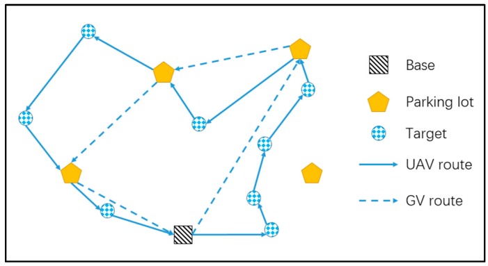
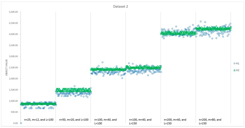
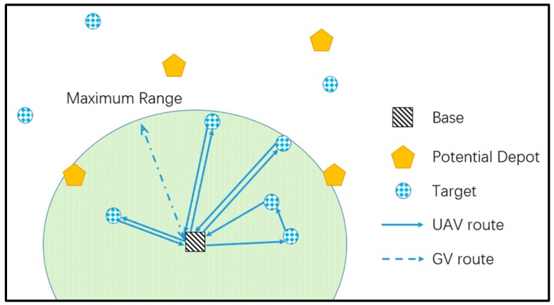
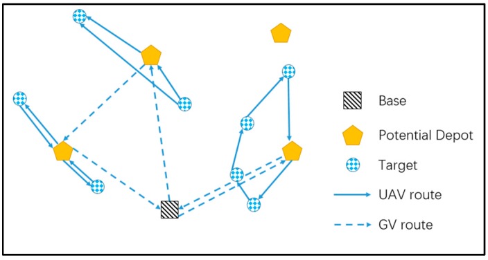
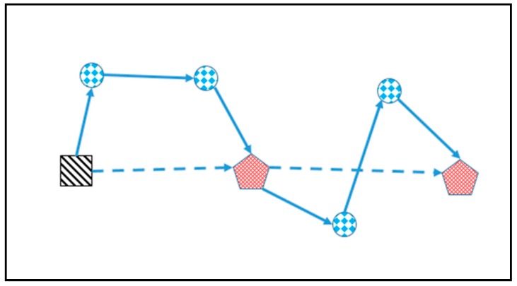
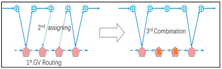
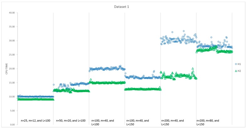
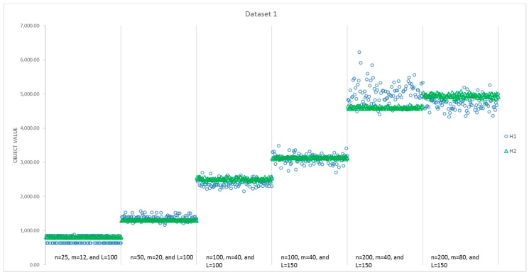
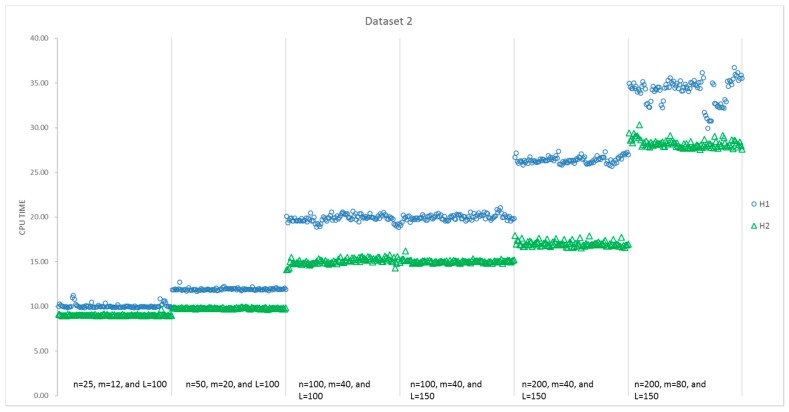
In this paper, a two-echelon cooperated routing problem for the ground vehicle (GV) and its carried unmanned aerial vehicle (UAV) is investigated, where the GV travels on the road network and its UAV travels in areas beyond the road to visit a number of targets unreached by the GV. In contrast to the classical two-echelon routing problem, the UAV has to launch and land on the GV frequently to change or charge its battery while the GV is moving on the road network. A new 0-1 integer programming model is developed to formulate the problem, where the constraints on the spatial and temporal cooperation of GV and UAV routes are included. Two heuristics are proposed to solve the model: the first heuristic (H1) constructs a complete tour for all targets and splits it by GV routes, while the second heuristic (H2) constructs the GV tour and assigns UAV flights to it. Random instances with six different sizes (25-200 targets, 12-80 rendezvous nodes) are used to test the algorithms. Computational results show that H1 performs slightly better than H2, while H2 uses less time and is more stable.

摘要

本文研究了地面车辆(GV)及其搭载的无人机(UAV)的两级协同路由问题,其中GV在道路网络上行驶,其UAV在道路以外的区域飞行以访问一些GV无法到达的目标。与经典的两级路由问题不同,当GV在道路网络上行驶时,UAV必须频繁地在GV上起降以更换电池或充电。开发了一种新的0-1整数规划模型来描述该问题,其中包括了GV和UAV路线的空间和时间协同约束。提出了两种启发式算法来求解该模型:第一种启发式算法(H1)为所有目标构建一条完整的路线并按GV路线进行划分,而第二种启发式算法(H2)构建GV路线并为其分配UAV飞行任务。使用具有六种不同规模(25 - 200个目标,12 - 80个会合节点)的随机实例来测试算法。计算结果表明,H1的性能略优于H2,而H2使用的时间更少且更稳定。

https://cdn.ncbi.nlm.nih.gov/pmc/blobs/efac/5470820/4c949dcb1fe8/sensors-17-01144-g010.jpg
https://cdn.ncbi.nlm.nih.gov/pmc/blobs/efac/5470820/a75d2304505f/sensors-17-01144-g001.jpg
https://cdn.ncbi.nlm.nih.gov/pmc/blobs/efac/5470820/8dbd2629dec5/sensors-17-01144-g002.jpg
https://cdn.ncbi.nlm.nih.gov/pmc/blobs/efac/5470820/5beaa815ec1d/sensors-17-01144-g003.jpg
https://cdn.ncbi.nlm.nih.gov/pmc/blobs/efac/5470820/54668a71b7a4/sensors-17-01144-g004.jpg
https://cdn.ncbi.nlm.nih.gov/pmc/blobs/efac/5470820/63a8dcf5b79b/sensors-17-01144-g005.jpg
https://cdn.ncbi.nlm.nih.gov/pmc/blobs/efac/5470820/018abb06c8b3/sensors-17-01144-g006.jpg
https://cdn.ncbi.nlm.nih.gov/pmc/blobs/efac/5470820/a5ba97668fce/sensors-17-01144-g007.jpg
https://cdn.ncbi.nlm.nih.gov/pmc/blobs/efac/5470820/cf14fbc40ad7/sensors-17-01144-g008.jpg
https://cdn.ncbi.nlm.nih.gov/pmc/blobs/efac/5470820/8322859547b9/sensors-17-01144-g009.jpg
https://cdn.ncbi.nlm.nih.gov/pmc/blobs/efac/5470820/4c949dcb1fe8/sensors-17-01144-g010.jpg

相似文献

1
A Two-Echelon Cooperated Routing Problem for a Ground Vehicle and Its Carried Unmanned Aerial Vehicle.地面车辆及其搭载无人机的两级协同路径规划问题
Sensors (Basel). 2017 May 17;17(5):1144. doi: 10.3390/s17051144.
2
An Optimal Routing Algorithm for Unmanned Aerial Vehicles.一种用于无人机的最优路径算法。
Sensors (Basel). 2021 Feb 9;21(4):1219. doi: 10.3390/s21041219.
3
Multi-UAV Routing for Area Coverage and Remote Sensing with Minimum Time.基于最短时间的多无人机区域覆盖与遥感路由
Sensors (Basel). 2015 Nov 2;15(11):27783-803. doi: 10.3390/s151127783.
4
A Two-Stage Approach for Routing Multiple Unmanned Aerial Vehicles with Stochastic Fuel Consumption.基于随机燃料消耗的多架无人机两阶段路径规划方法。
Sensors (Basel). 2018 Nov 3;18(11):3756. doi: 10.3390/s18113756.
5
Integrated optimization of unmanned aerial vehicle task allocation and path planning under steady wind.稳态风下无人机任务分配与路径规划的综合优化。
PLoS One. 2018 Mar 21;13(3):e0194690. doi: 10.1371/journal.pone.0194690. eCollection 2018.
6
Vehicle-Assisted UAV Delivery Scheme Considering Energy Consumption for Instant Delivery.考虑即时投递能量消耗的车载无人机投递方案
Sensors (Basel). 2022 Mar 5;22(5):2045. doi: 10.3390/s22052045.
7
A Novel Network Framework on Simultaneous Road Segmentation and Vehicle Detection for UAV Aerial Traffic Images.一种用于无人机空中交通图像的同时进行道路分割和车辆检测的新型网络框架。
Sensors (Basel). 2024 Jun 3;24(11):3606. doi: 10.3390/s24113606.
8
Dataset for the cumulative unmanned aerial vehicle routing problem.累积无人机路径规划问题的数据集。
Data Brief. 2023 Jun 5;48:109296. doi: 10.1016/j.dib.2023.109296. eCollection 2023 Jun.
9
Energy-efficient data routing in cooperative UAV swarms for medical assistance after a disaster.灾难后医疗辅助用的合作式无人机群中的节能数据路由。
Chaos. 2019 Jun;29(6):063106. doi: 10.1063/1.5092740.
10
A Space-Time Network-Based Modeling Framework for Dynamic Unmanned Aerial Vehicle Routing in Traffic Incident Monitoring Applications.一种基于时空网络的动态无人机路径规划建模框架,用于交通事件监测应用。
Sensors (Basel). 2015 Jun 12;15(6):13874-98. doi: 10.3390/s150613874.

引用本文的文献

1
Multi-depot routing problem with van-based driverless vehicles.基于厢式无人驾驶车辆的多配送点路径规划问题
Sci Rep. 2024 Aug 27;14(1):19807. doi: 10.1038/s41598-024-70781-0.
2
RETRACTED ARTICLE: A new truck-drone routing problem for parcel delivery by considering energy consumption and altitude.撤回文章:一种考虑能耗和高度的新型包裹递送卡车-无人机路径规划问题
Ann Oper Res. 2023 May 22;337(Suppl 1):5. doi: 10.1007/s10479-023-05381-8. eCollection 2024.
3
Drone routing problem model for last-mile delivery using the public transportation capacity as moving charging stations.

本文引用的文献

1
Enabling UAV Navigation with Sensor and Environmental Uncertainty in Cluttered and GPS-Denied Environments.在复杂且无GPS信号的环境中利用传感器和环境不确定性实现无人机导航
Sensors (Basel). 2016 May 10;16(5):666. doi: 10.3390/s16050666.
2
Multi-UAV Routing for Area Coverage and Remote Sensing with Minimum Time.基于最短时间的多无人机区域覆盖与遥感路由
Sensors (Basel). 2015 Nov 2;15(11):27783-803. doi: 10.3390/s151127783.
3
Cooperative surveillance and pursuit using unmanned aerial vehicles and unattended ground sensors.使用无人机和无人地面传感器进行协同监视与追踪。
以公共交通运力作为移动充电站的最后一英里配送无人机路径规划问题模型
Sci Rep. 2022 Apr 15;12(1):6361. doi: 10.1038/s41598-022-10408-4.
4
The adoption of self-driving delivery robots in last mile logistics.在最后一英里物流中采用自动驾驶配送机器人。
Transp Res E Logist Transp Rev. 2021 Feb;146:102214. doi: 10.1016/j.tre.2020.102214. Epub 2021 Jan 20.
5
Autonomous Mission of Multi-UAV for Optimal Area Coverage.用于最优区域覆盖的多无人机自主任务
Sensors (Basel). 2021 Apr 2;21(7):2482. doi: 10.3390/s21072482.
6
Traffic Patrolling Routing Problem with Drones in an Urban Road System.城市道路系统中无人机的交通巡逻路径问题。
Sensors (Basel). 2019 Nov 25;19(23):5164. doi: 10.3390/s19235164.
7
Towards the Internet of Flying Robots: A Survey.迈向飞行机器人的互联网:调查研究。
Sensors (Basel). 2018 Nov 19;18(11):4038. doi: 10.3390/s18114038.
Sensors (Basel). 2015 Jan 13;15(1):1365-88. doi: 10.3390/s150101365.