• 文献检索
  • 文档翻译
  • 深度研究
  • 学术资讯
  • Suppr Zotero 插件Zotero 插件
  • 邀请有礼
  • 套餐&价格
  • 历史记录
应用&插件
Suppr Zotero 插件Zotero 插件浏览器插件Mac 客户端Windows 客户端微信小程序
定价
高级版会员购买积分包购买API积分包
服务
文献检索文档翻译深度研究API 文档MCP 服务
关于我们
关于 Suppr公司介绍联系我们用户协议隐私条款
关注我们

Suppr 超能文献

核心技术专利:CN118964589B侵权必究
粤ICP备2023148730 号-1Suppr @ 2026

文献检索

告别复杂PubMed语法,用中文像聊天一样搜索,搜遍4000万医学文献。AI智能推荐,让科研检索更轻松。

立即免费搜索

文件翻译

保留排版,准确专业,支持PDF/Word/PPT等文件格式,支持 12+语言互译。

免费翻译文档

深度研究

AI帮你快速写综述,25分钟生成高质量综述,智能提取关键信息,辅助科研写作。

立即免费体验

末次间冰期海平面记录中动态地形信号的检测。

Detection of a dynamic topography signal in last interglacial sea-level records.

作者信息

Austermann Jacqueline, Mitrovica Jerry X, Huybers Peter, Rovere Alessio

机构信息

Department of Earth Sciences, University of Cambridge, Cambridge, UK.

Department of Earth and Planetary Sciences, Harvard University, Cambridge, MA 02138, USA.

出版信息

Sci Adv. 2017 Jul 7;3(7):e1700457. doi: 10.1126/sciadv.1700457. eCollection 2017 Jul.

DOI:10.1126/sciadv.1700457
PMID:28695210
原文链接:https://pmc.ncbi.nlm.nih.gov/articles/PMC5501501/
Abstract

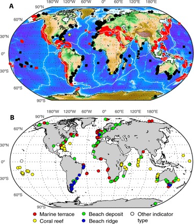
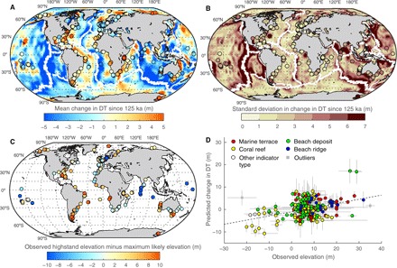
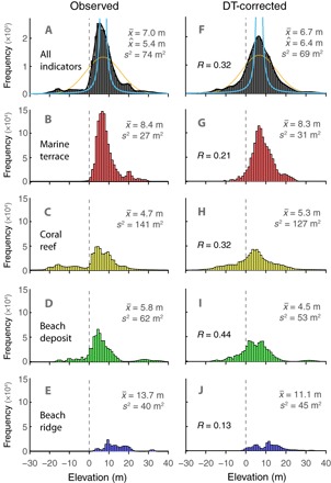
Estimating minimum ice volume during the last interglacial based on local sea-level indicators requires that these indicators are corrected for processes that alter local sea level relative to the global average. Although glacial isostatic adjustment is generally accounted for, global scale dynamic changes in topography driven by convective mantle flow are generally not considered. We use numerical models of mantle flow to quantify vertical deflections caused by dynamic topography and compare predictions at passive margins to a globally distributed set of last interglacial sea-level markers. The deflections predicted as a result of dynamic topography are significantly correlated with marker elevations (>95% probability) and are consistent with construction and preservation attributes across marker types. We conclude that a dynamic topography signal is present in the elevation of last interglacial sea-level records and that the signal must be accounted for in any effort to determine peak global mean sea level during the last interglacial to within an accuracy of several meters.

摘要

基于当地海平面指标估算末次间冰期的最小冰量,需要针对那些相对于全球平均值改变当地海平面的过程对这些指标进行校正。尽管一般会考虑冰川均衡调整,但通常不考虑由地幔对流引起的全球尺度地形动态变化。我们使用地幔流数值模型来量化由动态地形引起的垂直挠度,并将被动大陆边缘的预测结果与一组全球分布的末次间冰期海平面标志物进行比较。由动态地形预测的挠度与标志物海拔高度显著相关(概率大于95%),并且与各标志物类型的构造和保存属性一致。我们得出结论,末次间冰期海平面记录的海拔中存在动态地形信号,并且在任何旨在将末次间冰期全球平均海平面峰值确定在几米精度范围内的工作中,都必须考虑该信号。

https://cdn.ncbi.nlm.nih.gov/pmc/blobs/0826/5501501/edfa1ed707da/1700457-F3.jpg
https://cdn.ncbi.nlm.nih.gov/pmc/blobs/0826/5501501/455137b4ec6d/1700457-F1.jpg
https://cdn.ncbi.nlm.nih.gov/pmc/blobs/0826/5501501/944fc6abb048/1700457-F2.jpg
https://cdn.ncbi.nlm.nih.gov/pmc/blobs/0826/5501501/edfa1ed707da/1700457-F3.jpg
https://cdn.ncbi.nlm.nih.gov/pmc/blobs/0826/5501501/455137b4ec6d/1700457-F1.jpg
https://cdn.ncbi.nlm.nih.gov/pmc/blobs/0826/5501501/944fc6abb048/1700457-F2.jpg
https://cdn.ncbi.nlm.nih.gov/pmc/blobs/0826/5501501/edfa1ed707da/1700457-F3.jpg

相似文献

1
Detection of a dynamic topography signal in last interglacial sea-level records.末次间冰期海平面记录中动态地形信号的检测。
Sci Adv. 2017 Jul 7;3(7):e1700457. doi: 10.1126/sciadv.1700457. eCollection 2017 Jul.
2
Influence of reef isostasy, dynamic topography, and glacial isostatic adjustment on sea-level records in Northeastern Australia.珊瑚礁均衡、动力地形和冰川均衡调整对澳大利亚东北部海平面记录的影响。
Commun Earth Environ. 2023;4(1):328. doi: 10.1038/s43247-023-00967-3. Epub 2023 Sep 18.
3
Sea-level trends across The Bahamas constrain peak last interglacial ice melt.巴哈马群岛的海平面变化趋势限制了末次间冰期冰融化的峰值。
Proc Natl Acad Sci U S A. 2021 Aug 17;118(33). doi: 10.1073/pnas.2026839118.
4
Ice volume and sea level during the last interglacial.末次间冰期的冰量和海平面。
Science. 2012 Jul 13;337(6091):216-9. doi: 10.1126/science.1205749.
5
Probabilistic assessment of sea level during the last interglacial stage.末次间冰期海平面的概率评估。
Nature. 2009 Dec 17;462(7275):863-7. doi: 10.1038/nature08686.
6
Geodynamically corrected Pliocene shoreline elevations in Australia consistent with midrange projections of Antarctic ice loss.与南极冰损失的中等范围预测一致的澳大利亚经地球动力学校正的上新世海岸线海拔。
Sci Adv. 2023 Nov 15;9(46):eadg3035. doi: 10.1126/sciadv.adg3035. Epub 2023 Nov 17.
7
Bipolar seesaw control on last interglacial sea level.末次间冰期海平面的双相跷跷板控制。
Nature. 2015 Jun 11;522(7555):197-201. doi: 10.1038/nature14499.
8
Substantial contribution to sea-level rise during the last interglacial from the Greenland ice sheet.格陵兰冰盖对末次间冰期海平面上升有重大贡献。
Nature. 2000 Apr 6;404(6778):591-4. doi: 10.1038/35007053.
9
Arctic Ocean sea ice cover during the penultimate glacial and the last interglacial.倒数第二次冰期和末次间冰期期间的北冰洋海冰覆盖情况。
Nat Commun. 2017 Aug 29;8(1):373. doi: 10.1038/s41467-017-00552-1.
10
GIA imaging of 3-D mantle viscosity based on palaeo sea level observations - Part I: Sensitivity kernels for an Earth with laterally varying viscosity.基于古海平面观测的三维地幔粘度的GIA成像 - 第一部分:粘度横向变化地球的灵敏度核
Geophys J Int. 2023 Nov 21;236(2):1139-1171. doi: 10.1093/gji/ggad455. eCollection 2024 Feb.

引用本文的文献

1
Episodic reef growth in the Last Interglacial driven by competing influence of polar ice sheets to sea level rise.末次间冰期的间歇性珊瑚礁生长受极地冰盖对海平面上升的竞争影响驱动。
Sci Adv. 2025 Jun 13;11(24):eadu3701. doi: 10.1126/sciadv.adu3701.
2
Warming of +1.5 °C is too high for polar ice sheets.对极地冰盖而言,升温1.5摄氏度过高了。
Commun Earth Environ. 2025;6(1):351. doi: 10.1038/s43247-025-02299-w. Epub 2025 May 20.
3
Influence of reef isostasy, dynamic topography, and glacial isostatic adjustment on sea-level records in Northeastern Australia.

本文引用的文献

1
SEA-LEVEL RISE. Sea-level rise due to polar ice-sheet mass loss during past warm periods.海平面上升。过去温暖时期因极地冰盖质量损失导致的海平面上升。
Science. 2015 Jul 10;349(6244):aaa4019. doi: 10.1126/science.aaa4019. Epub 2015 Jul 9.
2
Dynamic topography change of the eastern United States since 3 million years ago.自 300 万年前以来美国东部的动态地形变化。
Science. 2013 Jun 28;340(6140):1560-3. doi: 10.1126/science.1229180. Epub 2013 May 16.
3
Ice volume and sea level during the last interglacial.末次间冰期的冰量和海平面。
珊瑚礁均衡、动力地形和冰川均衡调整对澳大利亚东北部海平面记录的影响。
Commun Earth Environ. 2023;4(1):328. doi: 10.1038/s43247-023-00967-3. Epub 2023 Sep 18.
4
Geodynamically corrected Pliocene shoreline elevations in Australia consistent with midrange projections of Antarctic ice loss.与南极冰损失的中等范围预测一致的澳大利亚经地球动力学校正的上新世海岸线海拔。
Sci Adv. 2023 Nov 15;9(46):eadg3035. doi: 10.1126/sciadv.adg3035. Epub 2023 Nov 17.
5
Constraining the contribution of the Antarctic Ice Sheet to Last Interglacial sea level.限制南极冰盖对末次间冰期海平面的贡献。
Sci Adv. 2023 Jul 7;9(27):eadf0198. doi: 10.1126/sciadv.adf0198. Epub 2023 Jul 5.
6
Sea-level trends across The Bahamas constrain peak last interglacial ice melt.巴哈马群岛的海平面变化趋势限制了末次间冰期冰融化的峰值。
Proc Natl Acad Sci U S A. 2021 Aug 17;118(33). doi: 10.1073/pnas.2026839118.
7
The Paris Climate Agreement and future sea-level rise from Antarctica.《巴黎协定》与未来南极洲海平面上升。
Nature. 2021 May;593(7857):83-89. doi: 10.1038/s41586-021-03427-0. Epub 2021 May 5.
8
Global influence of mantle temperature and plate thickness on intraplate volcanism.地幔温度和板块厚度对板内火山活动的全球影响。
Nat Commun. 2021 Apr 6;12(1):2045. doi: 10.1038/s41467-021-22323-9.
9
Sea-level stands from the Western Mediterranean over the past 6.5 million years.过去 650 万年,来自西地中海的海平面一直处于稳定状态。
Sci Rep. 2021 Jan 21;11(1):261. doi: 10.1038/s41598-020-80025-6.
10
Recent Progress in Greenland Ice Sheet Modelling.格陵兰冰盖建模的最新进展。
Curr Clim Change Rep. 2017;3(4):291-302. doi: 10.1007/s40641-017-0073-y. Epub 2017 Nov 13.
Science. 2012 Jul 13;337(6091):216-9. doi: 10.1126/science.1205749.
4
Probabilistic assessment of sea level during the last interglacial stage.末次间冰期海平面的概率评估。
Nature. 2009 Dec 17;462(7275):863-7. doi: 10.1038/nature08686.
5
Global change: Interglacial and future sea level.全球变化:间冰期与未来海平面。
Nature. 2009 Dec 17;462(7275):856-7. doi: 10.1038/462856a.