Sosa Victoria, Loera Israel
Biología Evolutiva, Instituto de Ecologia AC, Xalapa, Veracruz, Mexico.
PeerJ. 2017 Oct 20;5:e3932. doi: 10.7717/peerj.3932. eCollection 2017.
A number of biotic and abiotic factors have been proposed as drivers of geographic variation in species richness. As biotic elements, inter-specific interactions are the most widely recognized. Among abiotic factors, in particular for plants, climate and topographic variables as well as their historical variation have been correlated with species richness and endemism. In this study, we determine the extent to which the species richness and endemism of monocot geophyte species in Mesoamerica is predicted by current climate, historical climate stability and topography.
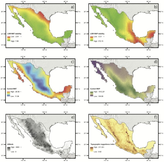
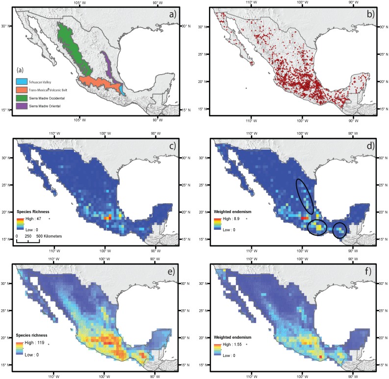
Using approximately 2,650 occurrence points representing 507 geophyte taxa, species richness (SR) and weighted endemism (WE) were estimated at a geographic scale using grids of 0.5 × 0.5 decimal degrees resolution using Mexico as the geographic extent. SR and WE were also estimated using species distributions inferred from ecological niche modeling for species with at least five spatially unique occurrence points. Current climate, current to Last Glacial Maximum temperature, precipitation stability and topographic features were used as predictor variables on multiple spatial regression analyses (i.e., spatial autoregressive models, SAR) using the estimates of SR and WE as response variables. The standardized coefficients of the predictor variables that were significant in the regression models were utilized to understand the observed patterns of species richness and endemism.
Our estimates of SR and WE based on direct occurrence data and distribution modeling generally yielded similar results, though estimates based on ecological niche modeling indicated broader distribution areas for SR and WE than when species richness was directly estimated using georeferenced coordinates. The SR and WE of monocot geophytes were highest along the Trans-Mexican Volcanic Belt, in both cases with higher levels in the central area of this mountain chain. Richness and endemism were also elevated in the southern regions of the Sierra Madre Oriental and Occidental mountain ranges, and in the Tehuacán Valley. Some areas of the Sierra Madre del Sur and Sierra Madre Oriental had high levels of WE, though they are not the areas with the highest SR. The spatial regressions suggest that SR is mostly influenced by current climate, whereas endemism is mainly affected by topography and precipitation stability.
Both methods (direct occurrence data and ecological niche modeling) used to estimate SR and WE in this study yielded similar results and detected a key area that should be considered in plant conservation strategies: the central region of the Trans-Mexican Volcanic Belt. Our results also corroborated that species richness is more closely correlated with current climate factors while endemism is related to differences in topography and to changes in precipitation levels compared to the LGM climatic conditions.
许多生物和非生物因素被认为是物种丰富度地理变异的驱动因素。作为生物因素,种间相互作用是最被广泛认可的。在非生物因素中,特别是对于植物而言,气候和地形变量及其历史变化与物种丰富度和特有性相关。在本研究中,我们确定了当前气候、历史气候稳定性和地形对中美洲单子叶地下芽植物物种丰富度和特有性的预测程度。
利用代表507个地下芽植物分类群的约2650个出现点,以墨西哥为地理范围,使用分辨率为0.5×0.5十进制度的网格在地理尺度上估计物种丰富度(SR)和加权特有性(WE)。对于具有至少五个空间上独特出现点的物种,还利用从生态位建模推断的物种分布来估计SR和WE。在多重空间回归分析(即空间自回归模型,SAR)中,将当前气候、当前至末次盛冰期的温度、降水稳定性和地形特征用作预测变量,以SR和WE的估计值作为响应变量。利用回归模型中显著的预测变量的标准化系数来理解观察到的物种丰富度和特有性模式。
我们基于直接出现数据和分布建模对SR和WE的估计通常产生相似的结果,尽管基于生态位建模的估计表明,与使用地理参考坐标直接估计物种丰富度相比,SR和WE的分布区域更广泛。单子叶地下芽植物的SR和WE在跨墨西哥火山带沿线最高,在这两种情况下,该山脉中部地区的水平更高。东马德雷山脉和西马德雷山脉的南部地区以及特瓦坎谷地的丰富度和特有性也有所提高。南马德雷山脉和东马德雷山脉的一些地区具有较高的WE水平,尽管它们不是SR最高的地区。空间回归表明,SR主要受当前气候影响,而特有性主要受地形和降水稳定性影响。
本研究中用于估计SR和WE的两种方法(直接出现数据和生态位建模)产生了相似的结果,并检测到了植物保护策略中应考虑的一个关键区域:跨墨西哥火山带的中部地区。我们的结果还证实,物种丰富度与当前气候因素的相关性更强,而特有性与地形差异以及与末次盛冰期气候条件相比降水水平的变化有关。