Zimbelman Eloise G, Keefe Robert F
Department of Forest, Rangeland and Fire Sciences, University of Idaho, Moscow, ID, United States of America.
PLoS One. 2018 Jan 11;13(1):e0191017. doi: 10.1371/journal.pone.0191017. eCollection 2018.
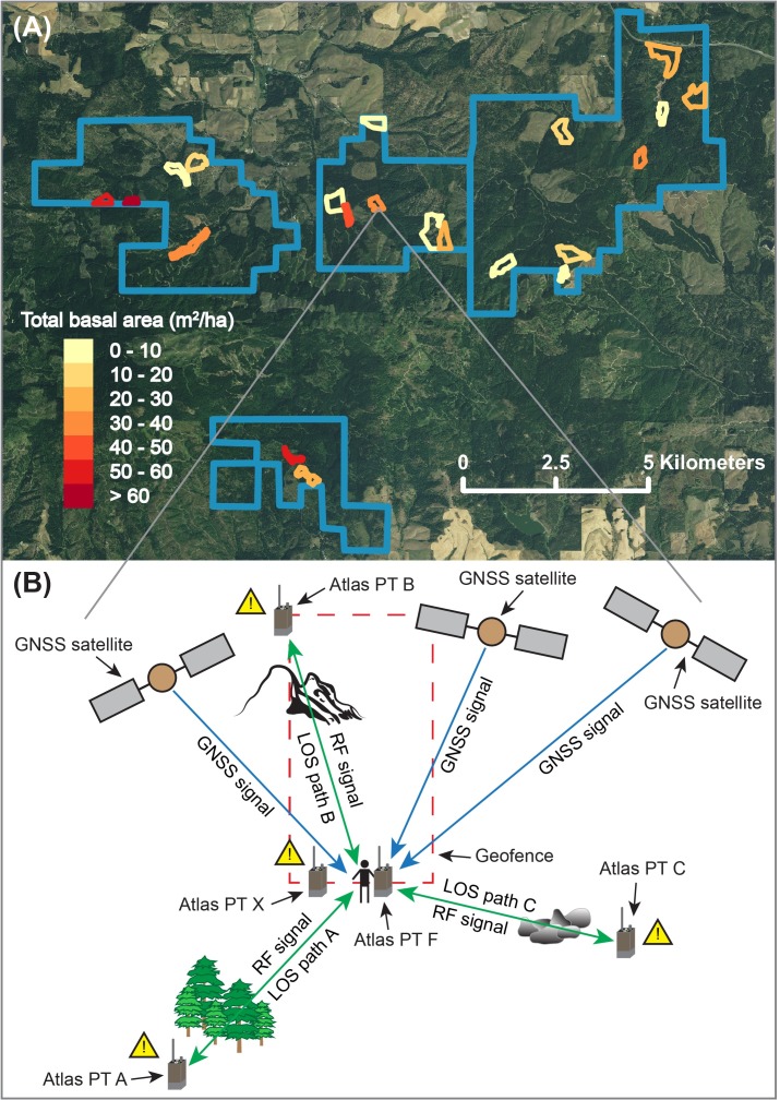
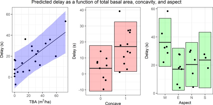
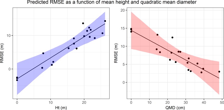
Real-time positioning on mobile devices using global navigation satellite system (GNSS) technology paired with radio frequency (RF) transmission (GNSS-RF) may help to improve safety on logging operations by increasing situational awareness. However, GNSS positional accuracy for ground workers in motion may be reduced by multipath error, satellite signal obstruction, or other factors. Radio propagation of GNSS locations may also be impacted due to line-of-sight (LOS) obstruction in remote, forested areas. The objective of this study was to characterize the effects of forest stand characteristics, topography, and other LOS obstructions on the GNSS accuracy and radio signal propagation quality of multiple Raveon Atlas PT GNSS-RF transponders functioning as a network in a range of forest conditions. Because most previous research with GNSS in forestry has focused on stationary units, we chose to analyze units in motion by evaluating the time-to-signal accuracy of geofence crossings in 21 randomly-selected stands on the University of Idaho Experimental Forest. Specifically, we studied the effects of forest stand characteristics, topography, and LOS obstructions on (1) the odds of missed GNSS-RF signals, (2) the root mean squared error (RMSE) of Atlas PTs, and (3) the time-to-signal accuracy of safety geofence crossings in forested environments. Mixed-effects models used to analyze the data showed that stand characteristics, topography, and obstructions in the LOS affected the odds of missed radio signals while stand variables alone affected RMSE. Both stand characteristics and topography affected the accuracy of geofence alerts.
使用全球导航卫星系统(GNSS)技术与射频(RF)传输相结合(GNSS-RF)在移动设备上进行实时定位,可能有助于通过增强态势感知来提高伐木作业的安全性。然而,运动中的地面工作人员的GNSS定位精度可能会因多径误差、卫星信号遮挡或其他因素而降低。在偏远的森林地区,由于视线(LOS)遮挡,GNSS位置的无线电传播也可能受到影响。本研究的目的是描述林分特征、地形和其他视线遮挡对多个Raveon Atlas PT GNSS-RF转发器在一系列森林条件下作为网络运行时的GNSS精度和无线电信号传播质量的影响。由于此前大多数关于林业中GNSS的研究都集中在固定装置上,我们选择通过评估爱达荷大学实验森林中21个随机选择的林分中地理围栏穿越的信号到达时间精度来分析移动装置。具体而言,我们研究了林分特征、地形和视线遮挡对以下方面的影响:(1)错过GNSS-RF信号的几率,(2)Atlas PT的均方根误差(RMSE),以及(3)森林环境中安全地理围栏穿越的信号到达时间精度。用于分析数据的混合效应模型表明,林分特征、地形和视线中的障碍物会影响错过无线电信号的几率,而仅林分变量会影响RMSE。林分特征和地形都会影响地理围栏警报的准确性。