• 文献检索
  • 文档翻译
  • 深度研究
  • 学术资讯
  • Suppr Zotero 插件Zotero 插件
  • 邀请有礼
  • 套餐&价格
  • 历史记录
应用&插件
Suppr Zotero 插件Zotero 插件浏览器插件Mac 客户端Windows 客户端微信小程序
定价
高级版会员购买积分包购买API积分包
服务
文献检索文档翻译深度研究API 文档MCP 服务
关于我们
关于 Suppr公司介绍联系我们用户协议隐私条款
关注我们

Suppr 超能文献

核心技术专利:CN118964589B侵权必究
粤ICP备2023148730 号-1Suppr @ 2026

文献检索

告别复杂PubMed语法,用中文像聊天一样搜索,搜遍4000万医学文献。AI智能推荐,让科研检索更轻松。

立即免费搜索

文件翻译

保留排版,准确专业,支持PDF/Word/PPT等文件格式,支持 12+语言互译。

免费翻译文档

深度研究

AI帮你快速写综述,25分钟生成高质量综述,智能提取关键信息,辅助科研写作。

立即免费体验

使用全球导航卫星系统-射频识别(GNSS-RF)表征缆索集材作业中索具操作人员与危险的接近程度:GNSS定位误差对工人安全状况的影响。

Characterizing Rigging Crew Proximity to Hazards on Cable Logging Operations Using GNSS-RF: Effect of GNSS Positioning Error on Worker Safety Status.

作者信息

Wempe Ann M, Keefe Robert F

机构信息

Forest Operations Research Lab, College of Natural Resources, University of Idaho, 875 Perimeter Drive, Moscow, ID 83844-1133, USA;

出版信息

Forests. 2017 Oct;8(10):357. doi: 10.3390/f8100357. Epub 2017 Sep 23.

DOI:10.3390/f8100357
PMID:30976381
原文链接:https://pmc.ncbi.nlm.nih.gov/articles/PMC6456079/
Abstract

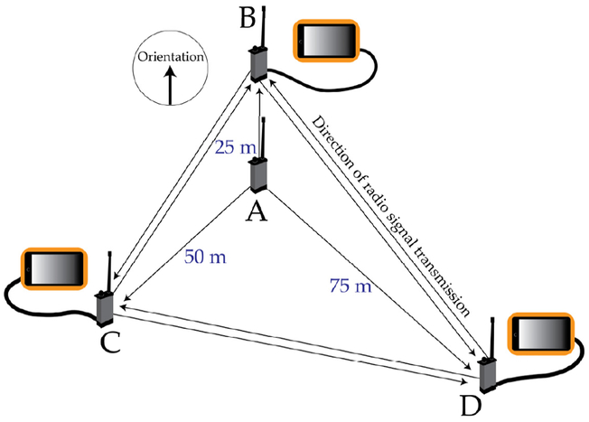
Logging continues to rank among the most lethal occupations in the United States. Though the hazards associated with fatalities are well-documented and safe distances from hazards is a common theme in safety education, positional relationships between workers and hazards have not been quantified previously. Using GNSS-RF (Global Navigation Satellite System-Radio Frequency) transponders that allow real-time monitoring of personnel, we collected positioning data for rigging crew workers and three common cable logging hazards: a log loader, skyline carriage, and snag. We summarized distances between all ground workers and each hazard on three active operations and estimated the proportion of time crew occupied higher-risk areas, as represented by geofences. We then assessed the extent to which positioning error associated with different stand conditions affected perceived worker safety status by applying error sampled in a separate, controlled field experiment to the operational data. Root mean squared error was estimated at 11.08 m in mature stands and 3.37 m in clearcuts. Simulated error expected for mature stands altered safety status in six of nine treatment combinations, whereas error expected for clearcuts affected only one. Our results show that canopy-associated GNSS error affects real-time geofence safety applications when using single-constellation American Global Positioning System transponders.

摘要

伐木业在美国仍是最具致命性的职业之一。尽管与死亡相关的危险已有详尽记录,且安全教育中常强调与危险保持安全距离,但此前工人与危险之间的位置关系尚未得到量化。我们使用能够对人员进行实时监测的全球导航卫星系统-射频(GNSS-RF)转发器,收集了索具作业工人以及三种常见的缆索伐木危险物(原木装载机、架空索道跑车和残干)的定位数据。我们总结了在三项实际作业中所有地面工人与每种危险物之间的距离,并估算了工作人员身处地理围栏所代表的高风险区域的时间比例。然后,我们通过将在单独的受控野外实验中采样的误差应用于作业数据,评估了与不同林分条件相关的定位误差对工人安全状态感知的影响程度。在成熟林分中,均方根误差估计为11.08米,在皆伐地中为3.37米。成熟林分预期的模拟误差在九种处理组合中的六种中改变了安全状态,而皆伐地预期的误差仅影响了一种。我们的结果表明,在使用单星座美国全球定位系统转发器时,与树冠相关的GNSS误差会影响实时地理围栏安全应用。

https://cdn.ncbi.nlm.nih.gov/pmc/blobs/4868/6456079/07a15c2a8792/nihms-989158-f0002.jpg
https://cdn.ncbi.nlm.nih.gov/pmc/blobs/4868/6456079/133ae79b8b5c/nihms-989158-f0001.jpg
https://cdn.ncbi.nlm.nih.gov/pmc/blobs/4868/6456079/07a15c2a8792/nihms-989158-f0002.jpg
https://cdn.ncbi.nlm.nih.gov/pmc/blobs/4868/6456079/133ae79b8b5c/nihms-989158-f0001.jpg
https://cdn.ncbi.nlm.nih.gov/pmc/blobs/4868/6456079/07a15c2a8792/nihms-989158-f0002.jpg

相似文献

1
Characterizing Rigging Crew Proximity to Hazards on Cable Logging Operations Using GNSS-RF: Effect of GNSS Positioning Error on Worker Safety Status.使用全球导航卫星系统-射频识别(GNSS-RF)表征缆索集材作业中索具操作人员与危险的接近程度:GNSS定位误差对工人安全状况的影响。
Forests. 2017 Oct;8(10):357. doi: 10.3390/f8100357. Epub 2017 Sep 23.
2
Hazards in Motion: Development of Mobile Geofences for Use in Logging Safety.运动中的危险:用于记录安全的移动地理围栏的开发。
Sensors (Basel). 2017 Apr 10;17(4):822. doi: 10.3390/s17040822.
3
Real-time positioning in logging: Effects of forest stand characteristics, topography, and line-of-sight obstructions on GNSS-RF transponder accuracy and radio signal propagation.测井中的实时定位:林分特征、地形及视线遮挡对全球导航卫星系统射频转发器精度和无线电信号传播的影响
PLoS One. 2018 Jan 11;13(1):e0191017. doi: 10.1371/journal.pone.0191017. eCollection 2018.
4
Accuracy of WAAS-Enabled GPS-RF Warning Signals When Crossing a Terrestrial Geofence.穿越地面地理围栏时启用广域增强系统(WAAS)的全球定位系统(GPS)-射频(RF)警告信号的准确性。
Sensors (Basel). 2016 Jun 18;16(6):912. doi: 10.3390/s16060912.
5
Human Factors Affecting Logging Injury Incidents in Idaho and the Potential for Real-Time Location-Sharing Technology to Improve Safety.影响爱达荷州伐木工伤事故的人为因素以及实时位置共享技术改善安全的潜力。
Safety (Basel). 2018 Oct;4(4):43. doi: 10.3390/safety4040043.
6
Development and validation of smartwatch-based activity recognition models for rigging crew workers on cable logging operations.基于智能手表的伐木作业索具工人活动识别模型的开发与验证。
PLoS One. 2021 May 12;16(5):e0250624. doi: 10.1371/journal.pone.0250624. eCollection 2021.
7
Benefits of Multi-Constellation/Multi-Frequency GNSS in a Tightly Coupled GNSS/IMU/Odometry Integration Algorithm.多星座/多频率 GNSS 在紧耦合 GNSS/IMU/里程计组合算法中的优势。
Sensors (Basel). 2018 Sep 12;18(9):3052. doi: 10.3390/s18093052.
8
Precise Point Positioning Using Triple GNSS Constellations in Various Modes.在各种模式下使用三重全球导航卫星系统星座进行精确点定位。
Sensors (Basel). 2016 May 28;16(6):779. doi: 10.3390/s16060779.
9
The Impact of Satellite Time Group Delay and Inter-Frequency Differential Code Bias Corrections on Multi-GNSS Combined Positioning.卫星时间群延迟和频率间差分码偏差校正对多全球导航卫星系统组合定位的影响
Sensors (Basel). 2017 Mar 16;17(3):602. doi: 10.3390/s17030602.
10
Enhanced GNSS Reliability on High-Dynamic Platforms: A Comparative Study of Multi-Frequency, Multi-Constellation Signals in Jamming Environments.高动态平台上增强型全球导航卫星系统(GNSS)的可靠性:干扰环境下多频多星座信号的比较研究
Sensors (Basel). 2023 Dec 1;23(23):9552. doi: 10.3390/s23239552.

引用本文的文献

1
Positioning Methods and the Use of Location and Activity Data in Forests.森林中的定位方法以及位置和活动数据的使用
Forests. 2019;10(5). doi: 10.3390/f10050458.
2
Lost in the woods: Forest vegetation, and not topography, most affects the connectivity of mesh radio networks for public safety.在森林中迷失:森林植被,而不是地形,对公共安全的网状无线网络的连通性影响最大。
PLoS One. 2022 Dec 7;17(12):e0278645. doi: 10.1371/journal.pone.0278645. eCollection 2022.
3
A novel smartphone-based activity recognition modeling method for tracked equipment in forest operations.

本文引用的文献

1
Hazards in Motion: Development of Mobile Geofences for Use in Logging Safety.运动中的危险:用于记录安全的移动地理围栏的开发。
Sensors (Basel). 2017 Apr 10;17(4):822. doi: 10.3390/s17040822.
2
Smart Device-Supported BDS/GNSS Real-Time Kinematic Positioning for Sub-Meter-Level Accuracy in Urban Location-Based Services.智能设备支持的北斗卫星导航系统/全球导航卫星系统实时动态定位用于城市基于位置服务中的亚米级精度
Sensors (Basel). 2016 Dec 21;16(12):2201. doi: 10.3390/s16122201.
3
Accuracy of WAAS-Enabled GPS-RF Warning Signals When Crossing a Terrestrial Geofence.
一种基于新型智能手机的森林作业中跟踪设备活动识别建模方法。
PLoS One. 2022 Apr 6;17(4):e0266568. doi: 10.1371/journal.pone.0266568. eCollection 2022.
4
Development and validation of smartwatch-based activity recognition models for rigging crew workers on cable logging operations.基于智能手表的伐木作业索具工人活动识别模型的开发与验证。
PLoS One. 2021 May 12;16(5):e0250624. doi: 10.1371/journal.pone.0250624. eCollection 2021.
5
The Dangerous Middle: Situational Awareness and Worker Perception of Beetle Kill.危险的中间地带:甲虫致死的情境意识与工人感知
J Agromedicine. 2019 Apr;24(2):157-166. doi: 10.1080/1059924X.2019.1567424. Epub 2019 Jan 22.
6
Human Factors Affecting Logging Injury Incidents in Idaho and the Potential for Real-Time Location-Sharing Technology to Improve Safety.影响爱达荷州伐木工伤事故的人为因素以及实时位置共享技术改善安全的潜力。
Safety (Basel). 2018 Oct;4(4):43. doi: 10.3390/safety4040043.
7
Real-time positioning in logging: Effects of forest stand characteristics, topography, and line-of-sight obstructions on GNSS-RF transponder accuracy and radio signal propagation.测井中的实时定位:林分特征、地形及视线遮挡对全球导航卫星系统射频转发器精度和无线电信号传播的影响
PLoS One. 2018 Jan 11;13(1):e0191017. doi: 10.1371/journal.pone.0191017. eCollection 2018.
穿越地面地理围栏时启用广域增强系统(WAAS)的全球定位系统(GPS)-射频(RF)警告信号的准确性。
Sensors (Basel). 2016 Jun 18;16(6):912. doi: 10.3390/s16060912.
4
Non-fatal injuries in the West Virginia logging industry: using workers' compensation claims to assess risk from 1995 through 2001.西弗吉尼亚州伐木业的非致命伤害:利用工伤赔偿申请评估1995年至2001年的风险
Am J Ind Med. 2003 Nov;44(5):502-9. doi: 10.1002/ajim.10307.
5
Documentation of hazards and safety perceptions for mechanized logging operations in East Central Alabama.阿拉巴马州中东部机械化伐木作业的危险与安全认知记录。
J Agric Saf Health. 2001 May;7(2):113-23. doi: 10.13031/2013.2673.