Irigoyen Alejo J, Rojo Irene, Calò Antonio, Trobbiani Gastón, Sánchez-Carnero Noela, García-Charton José A
Centro para el Estudio de Sistemas Marinos (CESIMAR), Consejo Nacional de Investigaciones Científicas y Técnicas (CCT CENPAT-CONICET). Boulevard Brown, Puerto Madryn, Chubut, Argentina.
Depto. Ecología e Hidrología-Universidad de Murcia, Campus de Espinardo, Murcia, Spain.
PLoS One. 2018 Jan 11;13(1):e0190990. doi: 10.1371/journal.pone.0190990. eCollection 2018.
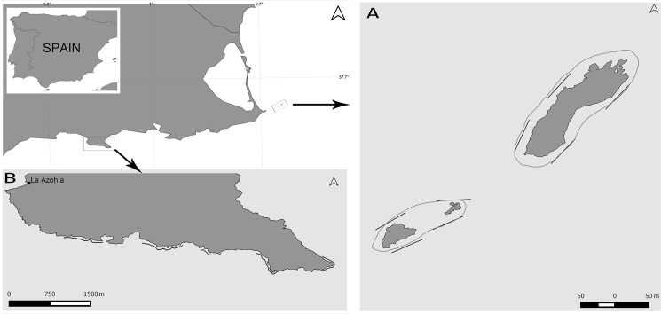
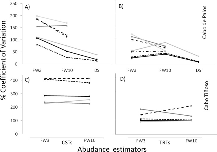
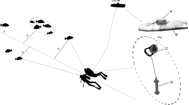
Underwater visual census (UVC) is the most common approach for estimating diversity, abundance and size of reef fishes in shallow and clear waters. Abundance estimation through UVC is particularly problematic in species occurring at low densities and/or highly aggregated because of their high variability at both spatial and temporal scales. The statistical power of experiments involving UVC techniques may be increased by augmenting the number of replicates or the area surveyed. In this work we present and test the efficiency of an UVC method based on diver towed GPS, the Tracked Roaming Transect (TRT), designed to maximize transect length (and thus the surveyed area) with respect to diving time invested in monitoring, as compared to Conventional Strip Transects (CST). Additionally, we analyze the effect of increasing transect width and length on the precision of density estimates by comparing TRT vs. CST methods using different fixed widths of 6 and 20 m (FW3 and FW10, respectively) and the Distance Sampling (DS) method, in which perpendicular distance of each fish or group of fishes to the transect line is estimated by divers up to 20 m from the transect line. The TRT was 74% more time and cost efficient than the CST (all transect widths considered together) and, for a given time, the use of TRT and/or increasing the transect width increased the precision of density estimates. In addition, since with the DS method distances of fishes to the transect line have to be estimated, and not measured directly as in terrestrial environments, errors in estimations of perpendicular distances can seriously affect DS density estimations. To assess the occurrence of distance estimation errors and their dependence on the observer's experience, a field experiment using wooden fish models was performed. We tested the precision and accuracy of density estimators based on fixed widths and the DS method. The accuracy of the estimates was measured comparing the actual total abundance with those estimated by divers using FW3, FW10, and DS estimators. Density estimates differed by 13% (range 0.1-31%) from the actual values (average = 13.09%; median = 14.16%). Based on our results we encourage the use of the Tracked Roaming Transect with Distance Sampling (TRT+DS) method for improving density estimates of species occurring at low densities and/or highly aggregated, as well as for exploratory rapid-assessment surveys in which divers could gather spatial ecological and ecosystem information on large areas during UVC.
水下视觉普查(UVC)是估计浅水和清澈水域中珊瑚礁鱼类多样性、丰度和大小最常用的方法。对于低密度出现和/或高度聚集的物种,通过UVC进行丰度估计尤其成问题,因为它们在空间和时间尺度上具有很高的变异性。涉及UVC技术的实验的统计效力可以通过增加重复次数或调查面积来提高。在这项工作中,我们展示并测试了一种基于潜水员拖曳GPS的UVC方法——跟踪漫游样带(TRT)的效率,与传统带状样带(CST)相比,该方法旨在相对于投入监测的潜水时间最大化样带长度(从而最大化调查面积)。此外,我们通过比较使用6米和20米不同固定宽度(分别为FW3和FW10)的TRT与CST方法以及距离抽样(DS)方法,分析增加样带宽度和长度对密度估计精度的影响,在DS方法中,潜水员估计每条鱼或每组鱼到样带线的垂直距离,最远可达离样带线20米处。TRT比CST(综合考虑所有样带宽度)在时间和成本上效率高74%,并且在给定时间内,使用TRT和/或增加样带宽度提高了密度估计的精度。此外,由于在DS方法中必须估计鱼到样带线的距离,而不像在陆地环境中那样直接测量,垂直距离估计中的误差会严重影响DS密度估计。为了评估距离估计误差的发生情况及其对观察者经验的依赖性,进行了一项使用木鱼模型的现场实验。我们测试了基于固定宽度和DS方法的密度估计器的精度和准确性。通过将实际总丰度与潜水员使用FW3、FW10和DS估计器估计的丰度进行比较来测量估计的准确性。密度估计值与实际值相差13%(范围为0.1 - 31%)(平均值 = 13.09%;中位数 = 14.16%)。基于我们的结果,我们鼓励使用带距离抽样的跟踪漫游样带(TRT + DS)方法来提高低密度出现和/或高度聚集物种的密度估计,以及用于探索性快速评估调查,在水下视觉普查期间,潜水员可以在大面积上收集空间生态和生态系统信息。