• 文献检索
  • 文档翻译
  • 深度研究
  • 学术资讯
  • Suppr Zotero 插件Zotero 插件
  • 邀请有礼
  • 套餐&价格
  • 历史记录
应用&插件
Suppr Zotero 插件Zotero 插件浏览器插件Mac 客户端Windows 客户端微信小程序
定价
高级版会员购买积分包购买API积分包
服务
文献检索文档翻译深度研究API 文档MCP 服务
关于我们
关于 Suppr公司介绍联系我们用户协议隐私条款
关注我们

Suppr 超能文献

核心技术专利:CN118964589B侵权必究
粤ICP备2023148730 号-1Suppr @ 2026

文献检索

告别复杂PubMed语法,用中文像聊天一样搜索,搜遍4000万医学文献。AI智能推荐,让科研检索更轻松。

立即免费搜索

文件翻译

保留排版,准确专业,支持PDF/Word/PPT等文件格式,支持 12+语言互译。

免费翻译文档

深度研究

AI帮你快速写综述,25分钟生成高质量综述,智能提取关键信息,辅助科研写作。

立即免费体验

阿拉斯加北部北极沿海平原的冻土地貌和植被生产力趋势图。

Tundra landform and vegetation productivity trend maps for the Arctic Coastal Plain of northern Alaska.

机构信息

Department of Plant Biology, University of Illinois Urbana-Champaign, Urbana, Illinois 61801, USA.

Institute of Arctic Biology, University of Alaska Fairbanks, Fairbanks, Alaska 99775, USA.

出版信息

Sci Data. 2018 Apr 10;5:180058. doi: 10.1038/sdata.2018.58.

DOI:10.1038/sdata.2018.58
PMID:29633984
原文链接:https://pmc.ncbi.nlm.nih.gov/articles/PMC5892374/
Abstract

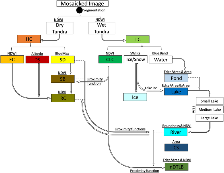
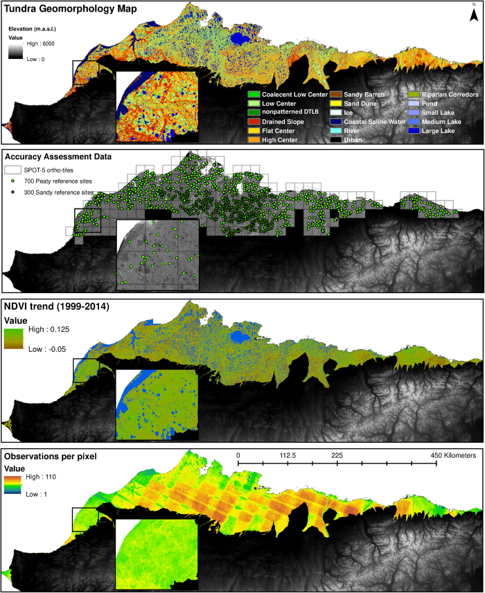
Arctic tundra landscapes are composed of a complex mosaic of patterned ground features, varying in soil moisture, vegetation composition, and surface hydrology over small spatial scales (10-100 m). The importance of microtopography and associated geomorphic landforms in influencing ecosystem structure and function is well founded, however, spatial data products describing local to regional scale distribution of patterned ground or polygonal tundra geomorphology are largely unavailable. Thus, our understanding of local impacts on regional scale processes (e.g., carbon dynamics) may be limited. We produced two key spatiotemporal datasets spanning the Arctic Coastal Plain of northern Alaska (~60,000 km) to evaluate climate-geomorphological controls on arctic tundra productivity change, using (1) a novel 30 m classification of polygonal tundra geomorphology and (2) decadal-trends in surface greenness using the Landsat archive (1999-2014). These datasets can be easily integrated and adapted in an array of local to regional applications such as (1) upscaling plot-level measurements (e.g., carbon/energy fluxes), (2) mapping of soils, vegetation, or permafrost, and/or (3) initializing ecosystem biogeochemistry, hydrology, and/or habitat modeling.

摘要

北极冻原景观由复杂的图案地面特征镶嵌而成,这些特征在小空间尺度(10-100m)上表现出土壤湿度、植被组成和地表水文学的变化。微地形及其相关地貌形态对影响生态系统结构和功能的重要性是有充分依据的,然而,描述图案地面或多边形冻原地貌的局部到区域尺度分布的空间数据产品在很大程度上是不可用的。因此,我们对局部对区域尺度过程(例如碳动态)的影响的理解可能是有限的。我们制作了两个关键的时空数据集,涵盖了阿拉斯加北部北极沿海平原(约 60,000km),以评估气候地貌学对北极冻原生产力变化的控制作用,使用了(1)一种新的 30m 多边形冻原地貌分类,以及(2)利用陆地卫星档案(1999-2014 年)评估地表绿色度的十年趋势。这些数据集可以轻松地在各种局部到区域应用中进行集成和调整,例如(1)放大斑块尺度的测量(例如碳/能量通量),(2)绘制土壤、植被或永久冻土图,以及/或(3)初始化生态系统生物地球化学、水文学和/或栖息地模型。

https://cdn.ncbi.nlm.nih.gov/pmc/blobs/6a68/5892374/756dece7f895/sdata201858-f3.jpg
https://cdn.ncbi.nlm.nih.gov/pmc/blobs/6a68/5892374/1fb25f396f6f/sdata201858-f1.jpg
https://cdn.ncbi.nlm.nih.gov/pmc/blobs/6a68/5892374/aa05a7e0115d/sdata201858-f2.jpg
https://cdn.ncbi.nlm.nih.gov/pmc/blobs/6a68/5892374/756dece7f895/sdata201858-f3.jpg
https://cdn.ncbi.nlm.nih.gov/pmc/blobs/6a68/5892374/1fb25f396f6f/sdata201858-f1.jpg
https://cdn.ncbi.nlm.nih.gov/pmc/blobs/6a68/5892374/aa05a7e0115d/sdata201858-f2.jpg
https://cdn.ncbi.nlm.nih.gov/pmc/blobs/6a68/5892374/756dece7f895/sdata201858-f3.jpg

相似文献

1
Tundra landform and vegetation productivity trend maps for the Arctic Coastal Plain of northern Alaska.阿拉斯加北部北极沿海平原的冻土地貌和植被生产力趋势图。
Sci Data. 2018 Apr 10;5:180058. doi: 10.1038/sdata.2018.58.
2
Reduced arctic tundra productivity linked with landform and climate change interactions.北极冻原生态系统生产力下降与地形和气候变化的相互作用有关。
Sci Rep. 2018 Feb 5;8(1):2345. doi: 10.1038/s41598-018-20692-8.
3
Local-scale Arctic tundra heterogeneity affects regional-scale carbon dynamics.局地尺度北极苔原生态系统异质性影响区域尺度碳动态。
Nat Commun. 2020 Oct 1;11(1):4925. doi: 10.1038/s41467-020-18768-z.
4
Landscape impacts of 3D-seismic surveys in the Arctic National Wildlife Refuge, Alaska.在阿拉斯加北极国家野生动物保护区,三维地震调查的景观影响。
Ecol Appl. 2020 Oct;30(7):e02143. doi: 10.1002/eap.2143. Epub 2020 May 26.
5
Polygonal tundra geomorphological change in response to warming alters future CO2 and CH4 flux on the Barrow Peninsula.多边形冻原地貌因变暖而发生变化,这将改变巴罗半岛未来的 CO2 和 CH4 通量。
Glob Chang Biol. 2015 Apr;21(4):1634-51. doi: 10.1111/gcb.12757. Epub 2014 Nov 17.
6
Historical and projected trends in landscape drivers affecting carbon dynamics in Alaska.历史和预测的景观驱动因素变化趋势对阿拉斯加碳动态的影响。
Ecol Appl. 2017 Jul;27(5):1383-1402. doi: 10.1002/eap.1538. Epub 2017 May 22.
7
Changes in vegetation in northern Alaska under scenarios of climate change, 2003-2100: implications for climate feedbacks.2003 - 2100年气候变化情景下阿拉斯加北部植被的变化:对气候反馈的影响
Ecol Appl. 2009 Jun;19(4):1022-43. doi: 10.1890/08-0806.1.
8
Spatiotemporal remote sensing of ecosystem change and causation across Alaska.阿拉斯加生态系统变化及其成因的时空遥感研究。
Glob Chang Biol. 2019 Mar;25(3):1171-1189. doi: 10.1111/gcb.14279. Epub 2018 May 28.
9
Modelling carbon responses of tundra ecosystems to historical and projected climate: sensitivity of pan-Arctic carbon storage to temporal and spatial variation in climate.模拟苔原生态系统对历史和预测气候的碳响应:泛北极碳储存对气候时空变化的敏感性。
Glob Chang Biol. 2000 Dec;6(S1):141-159. doi: 10.1046/j.1365-2486.2000.06017.x. Epub 2002 Jan 5.
10
Isotopic compositions of ground ice in near-surface permafrost in relation to vegetation and microtopography at the Taiga-Tundra boundary in the Indigirka River lowlands, northeastern Siberia.西伯利亚东北部因迪吉尔卡河流域泰加林-苔原边界近地表永久冻土中与植被和微地形有关的地面冰同位素组成。
PLoS One. 2019 Oct 10;14(10):e0223720. doi: 10.1371/journal.pone.0223720. eCollection 2019.

引用本文的文献

1
Permafrost thaw subsidence, sea-level rise, and erosion are transforming Alaska's Arctic coastal zone.永久冻土融化下沉、海平面上升和侵蚀正在改变阿拉斯加的北极海岸带。
Proc Natl Acad Sci U S A. 2024 Dec 10;121(50):e2409411121. doi: 10.1073/pnas.2409411121. Epub 2024 Dec 3.
2
Thermokarst landscape exhibits large nitrous oxide emissions in Alaska's coastal polygonal tundra.热喀斯特地貌在阿拉斯加沿海多边形冻原地区呈现出大量一氧化二氮排放。
Commun Earth Environ. 2024;5(1):473. doi: 10.1038/s43247-024-01583-5. Epub 2024 Aug 30.
3
Use of Very High Spatial Resolution Commercial Satellite Imagery and Deep Learning to Automatically Map Ice-Wedge Polygons across Tundra Vegetation Types.

本文引用的文献

1
Hierarchical subdivision of Arctic tundra based on vegetation response to climate, parent material and topography.基于植被对气候、母质和地形的响应的北极苔原的层次细分。
Glob Chang Biol. 2000 Dec;6(S1):19-34. doi: 10.1046/j.1365-2486.2000.06010.x. Epub 2002 Jan 5.
2
Reduced arctic tundra productivity linked with landform and climate change interactions.北极冻原生态系统生产力下降与地形和气候变化的相互作用有关。
Sci Rep. 2018 Feb 5;8(1):2345. doi: 10.1038/s41598-018-20692-8.
3
Polygonal tundra geomorphological change in response to warming alters future CO2 and CH4 flux on the Barrow Peninsula.
利用超高空间分辨率商业卫星图像和深度学习自动绘制苔原植被类型中的冰楔多边形图。
J Imaging. 2020 Dec 11;6(12):137. doi: 10.3390/jimaging6120137.
4
Local-scale Arctic tundra heterogeneity affects regional-scale carbon dynamics.局地尺度北极苔原生态系统异质性影响区域尺度碳动态。
Nat Commun. 2020 Oct 1;11(1):4925. doi: 10.1038/s41467-020-18768-z.
5
Identifying historical and future potential lake drainage events on the western Arctic coastal plain of Alaska.识别阿拉斯加北极西部沿海平原过去和未来潜在的湖泊排水事件。
Permafr Periglac Process. 2020 Jan-Mar;31(1):110-127. doi: 10.1002/ppp.2038. Epub 2020 Feb 21.
6
High-resolution mapping of spatial heterogeneity in ice wedge polygon geomorphology near Prudhoe Bay, Alaska.高分辨率绘制阿拉斯加普拉德霍湾附近冰楔多边形地貌的空间异质性图。
Sci Data. 2020 Mar 10;7(1):87. doi: 10.1038/s41597-020-0423-9.
7
Regional mapping of species-level continuous foliar cover: beyond categorical vegetation mapping.物种级连续叶盖的区域制图:超越分类植被制图。
Ecol Appl. 2020 Jun;30(4):e02081. doi: 10.1002/eap.2081. Epub 2020 Feb 24.
8
Reduced arctic tundra productivity linked with landform and climate change interactions.北极冻原生态系统生产力下降与地形和气候变化的相互作用有关。
Sci Rep. 2018 Feb 5;8(1):2345. doi: 10.1038/s41598-018-20692-8.
多边形冻原地貌因变暖而发生变化,这将改变巴罗半岛未来的 CO2 和 CH4 通量。
Glob Chang Biol. 2015 Apr;21(4):1634-51. doi: 10.1111/gcb.12757. Epub 2014 Nov 17.