Department of Civil and Environmental Engineering, Dongguk University, Seoul 04620, Korea.
Sensors (Basel). 2018 Jun 28;18(7):2082. doi: 10.3390/s18072082.
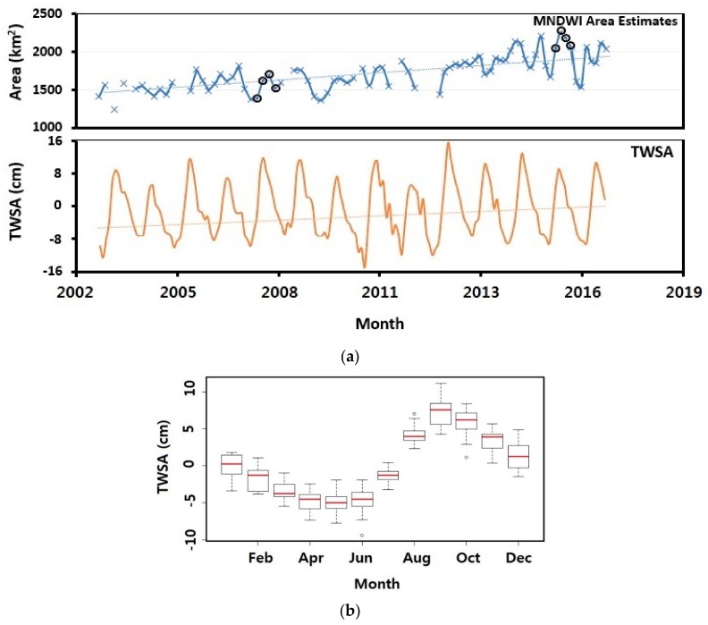
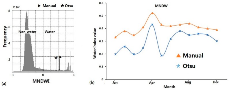
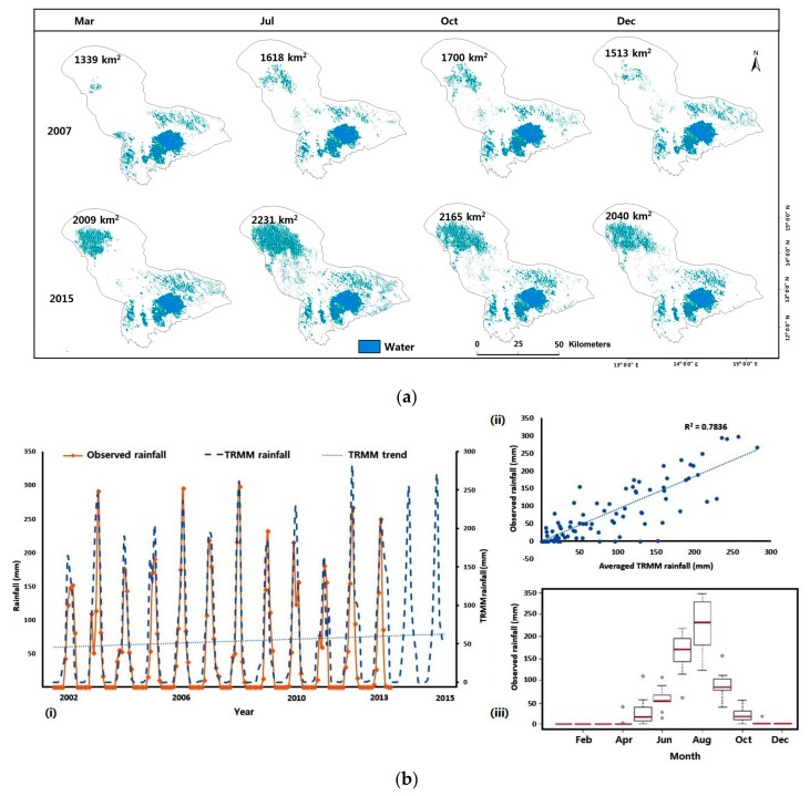
Consistent observations of lakes and reservoirs that comprise the majority of surface freshwater globally are limited, especially in Africa where water bodies are exposed to unfavorable climatic conditions and human interactions. Publicly available satellite imagery has increased the ability to monitor water bodies of various sizes without much financial hassle. Landsat 7 and 8 images were used in this study to estimate area changes around Lake Chad. The Automated Water Extraction Index (AWEI), Normalized Difference Water Index (NDWI), Modified Normalized Difference Water Index (MNDWI) and Normalized Difference Vegetation Index (NDVI) were compared for the remote sensing retrieval process of surface water. Otsu threshold method was used to separate water from non-water features. With an overall accuracy of ~96% and an inter-rater agreement (kappa coefficient) of 0.91, the MNDWI was a better indicator for mapping recent area changes in Lake Chad and was used to estimate the lake’s area changes from 2003⁻2016. Extracted monthly areas showed an increasing trend and ranged between ~1242 km² and 2231 km² indicating high variability within the 13-year period, 2003⁻2016. In addition, we combined Landsat measurements with Total Water Storage Anomaly (TWSA) data from the Gravity Recovery and Climate Experiment (GRACE) satellites. This combination is well matched with our estimated surface area trends. This work not only demonstrates the importance of remote sensing in sparsely gauged developing countries, it also suggests the use of freely available high-quality imagery data to address existing lake crisis.
对构成全球大部分地表淡水的湖泊和水库进行一致的观测受到限制,特别是在非洲,那里的水体受到不利的气候条件和人类活动的影响。现有的卫星图像使人们能够在无需大量资金投入的情况下监测各种规模的水体。本研究使用 Landsat 7 和 8 图像来估计乍得湖周边地区的面积变化。自动水体提取指数(AWEI)、归一化差异水体指数(NDWI)、改进归一化差异水体指数(MNDWI)和归一化差异植被指数(NDVI)被用于地表水的遥感提取过程。Otsu 阈值法用于将水体与非水体特征分离。MNDWI 的整体精度约为 96%,且具有较高的内部一致性(kappa 系数)0.91,因此它是一种更好的指示符,可用于绘制乍得湖近期的面积变化,并用于估算 2003-2016 年期间该湖的面积变化。提取的每月面积呈上升趋势,范围在~1242km²和 2231km²之间,表明在 13 年期间内具有高度的可变性。此外,我们将 Landsat 测量值与重力恢复和气候实验(GRACE)卫星的总水存储异常(TWSA)数据相结合。这种组合与我们估计的地表面积趋势非常吻合。这项工作不仅展示了遥感在数据匮乏的发展中国家的重要性,还表明可以利用免费提供的高质量图像数据来解决现有的湖泊危机。