Marine Geospatial Ecology Lab, Nicholas School of the Environment, Duke University, Durham, NC 27708, USA.
Nippon Foundation Nereus Program and Changing Ocean Research Unit, Institute for the Oceans and Fisheries, The University of British Columbia, Vancouver, British Columbia, Canada.
Sci Adv. 2018 Aug 8;4(8):eaat3681. doi: 10.1126/sciadv.aat3681. eCollection 2018 Aug.
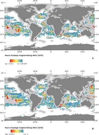
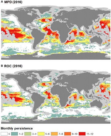
International interest in the protection and sustainable use of high seas biodiversity has grown in recent years. There is an opportunity for new technologies to enable improvements in management of these areas beyond national jurisdiction. We explore the spatial ecology and drivers of the global distribution of the high seas longline fishing fleet by creating predictive models of the distribution of fishing effort from newly available automatic identification system (AIS) data. Our results show how longline fishing effort can be predicted using environmental variables, many related to the expected distribution of the species targeted by longliners. We also find that the longline fleet has seasonal environmental preferences (for example, increased importance of cooler surface waters during boreal summer) and may only be using 38 to 64% of the available environmentally suitable fishing habitat. Possible explanations include misclassification of fishing effort, incomplete AIS coverage, or how potential range contractions of pelagic species may have reduced the abundance of fishing habitats in the open ocean.
近年来,国际社会对保护和可持续利用公海生物多样性的兴趣日益浓厚。新技术有机会在国家管辖范围之外改善对这些区域的管理。我们通过利用新获得的自动识别系统 (AIS) 数据创建捕捞努力分布的预测模型,探索公海延绳钓渔业船队的空间生态和全球分布的驱动因素。我们的研究结果表明,如何使用与延绳钓渔民目标物种预期分布相关的许多环境变量来预测延绳钓捕捞努力。我们还发现,延绳钓船队具有季节性的环境偏好(例如,在北方夏季,更需要凉爽的表层水),并且可能只利用了 38%至 64%的可用环境适宜的捕捞栖息地。可能的解释包括捕捞努力的错误分类、AIS 覆盖的不完整或远洋物种潜在范围收缩如何减少公海的捕捞栖息地的丰度。