• 文献检索
  • 文档翻译
  • 深度研究
  • 学术资讯
  • Suppr Zotero 插件Zotero 插件
  • 邀请有礼
  • 套餐&价格
  • 历史记录
应用&插件
Suppr Zotero 插件Zotero 插件浏览器插件Mac 客户端Windows 客户端微信小程序
定价
高级版会员购买积分包购买API积分包
服务
文献检索文档翻译深度研究API 文档MCP 服务
关于我们
关于 Suppr公司介绍联系我们用户协议隐私条款
关注我们

Suppr 超能文献

核心技术专利:CN118964589B侵权必究
粤ICP备2023148730 号-1Suppr @ 2026

文献检索

告别复杂PubMed语法,用中文像聊天一样搜索,搜遍4000万医学文献。AI智能推荐,让科研检索更轻松。

立即免费搜索

文件翻译

保留排版,准确专业,支持PDF/Word/PPT等文件格式,支持 12+语言互译。

免费翻译文档

深度研究

AI帮你快速写综述,25分钟生成高质量综述,智能提取关键信息,辅助科研写作。

立即免费体验

剖析与解读三维探地雷达数据集:来自澳大利亚北部的实例。

Dissecting and Interpreting a Three-Dimensional Ground-Penetrating Radar Dataset: An Example from Northern Australia.

机构信息

Department of Anthropology, University of Denver, Denver, CO 80210, USA.

Virtus Heritage, Pottsville 2489, Queensland, Australia.

出版信息

Sensors (Basel). 2019 Mar 12;19(5):1239. doi: 10.3390/s19051239.

DOI:10.3390/s19051239
PMID:30871016
原文链接:https://pmc.ncbi.nlm.nih.gov/articles/PMC6427176/
Abstract

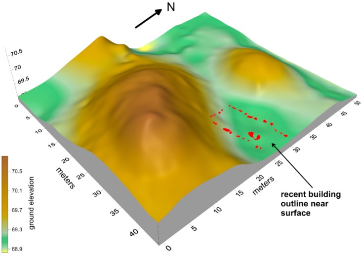
A robust 3-D GPR dataset provides interpreters with a variety of methods for extracting important information at buried archaeological sites. An iterative approach that uses reflection profile analysis, amplitude slice-mapping, and often both in conjunction is often necessary as neither method by itself is sufficient. In northern Australia, two constructed mounds contain a number of cultural and geological horizons and features, which can be imaged with GPR. The reflection profiles display the modified ground surface prior to mound construction and some initial construction layers. On the pre-mound surface, amplitude maps of reflective layers that were built-up on the ground surface indicate that they were constructed in an intentional manner. Those surfaces were later covered by sand to produce mounds used for human burial. Human internments in the mound can only be seen in reflection profiles, but once discovered, the profiles can be re-sliced to produce high definition amplitude images of these remains. No one method of analysis can provide an overall interpretation of these complex internal mound features. When the methods are varied, depending on the results of one method, a detailed and varied analysis of certain aspects of the mounds' internal features are visible, leading to the generation of a number of hypotheses about how this area of northern Australia was used in the past. The 3-D data from GPR shows that this area was an important location on the landscape in the past, and was modified by the construction of a monumental mound, which was then used for human burials, and more recently, the construction of what was likely a ritual enclosure.

摘要

一个强大的三维探地雷达数据集为解译人员提供了各种方法,以便从埋藏的考古遗址中提取重要信息。一种迭代方法,通常结合反射剖面分析、振幅切片映射以及两者,是必要的,因为这两种方法本身都不够充分。在澳大利亚北部,两个建造的土丘包含了许多文化和地质层面和特征,可以用探地雷达进行成像。反射剖面显示了在土丘建造之前的修改后的地面表面和一些初始建造层。在土丘表面之前,反射层的振幅图显示了它们是在地面上有意建造的。这些表面后来被沙子覆盖,形成了用于人类埋葬的土丘。在土丘中的人类埋葬只能在反射剖面上看到,但一旦发现,这些剖面可以重新切片,以产生这些遗骸的高清晰度振幅图像。没有一种分析方法可以提供对这些复杂的内部土丘特征的整体解释。当根据一种方法的结果改变方法时,可以对土丘内部特征的某些方面进行详细和多样化的分析,从而产生关于澳大利亚北部这一地区过去如何使用的一些假设。探地雷达的三维数据表明,该地区过去是景观中的一个重要位置,通过建造一座纪念性的土丘进行了修改,然后用于人类埋葬,最近,可能建造了一个仪式围场。

https://cdn.ncbi.nlm.nih.gov/pmc/blobs/352f/6427176/5827a07fa11a/sensors-19-01239-g002.jpg
https://cdn.ncbi.nlm.nih.gov/pmc/blobs/352f/6427176/c5eb3cbbd564/sensors-19-01239-g001.jpg
https://cdn.ncbi.nlm.nih.gov/pmc/blobs/352f/6427176/5827a07fa11a/sensors-19-01239-g002.jpg
https://cdn.ncbi.nlm.nih.gov/pmc/blobs/352f/6427176/c5eb3cbbd564/sensors-19-01239-g001.jpg
https://cdn.ncbi.nlm.nih.gov/pmc/blobs/352f/6427176/5827a07fa11a/sensors-19-01239-g002.jpg

相似文献

1
Dissecting and Interpreting a Three-Dimensional Ground-Penetrating Radar Dataset: An Example from Northern Australia.剖析与解读三维探地雷达数据集:来自澳大利亚北部的实例。
Sensors (Basel). 2019 Mar 12;19(5):1239. doi: 10.3390/s19051239.
2
The utility of ground-penetrating radar and its time-dependence in the discovery of clandestine burials.探地雷达的效用及其在发现秘密埋葬地点方面的时间依赖性。
Forensic Sci Int. 2015 Aug;253:119-24. doi: 10.1016/j.forsciint.2015.06.006. Epub 2015 Jun 14.
3
Sequential monitoring of burials containing small pig cadavers using ground penetrating radar.使用探地雷达对装有小猪尸体的墓葬进行连续监测。
J Forensic Sci. 2008 Mar;53(2):279-87. doi: 10.1111/j.1556-4029.2008.00665.x.
4
Sequential monitoring of burials containing large pig cadavers using ground-penetrating radar.使用探地雷达对装有大型猪尸体的墓葬进行连续监测。
J Forensic Sci. 2006 May;51(3):607-16. doi: 10.1111/j.1556-4029.2006.00129.x.
5
Preliminary results of sequential monitoring of simulated clandestine graves in Colombia, South America, using ground penetrating radar and botany.在南美洲哥伦比亚,使用探地雷达和植物学对模拟秘密坟墓进行连续监测的初步结果。
Forensic Sci Int. 2015 Mar;248:61-70. doi: 10.1016/j.forsciint.2014.12.011. Epub 2014 Dec 20.
6
Geophysical monitoring of simulated graves with resistivity, magnetic susceptibility, conductivity and GPR in Colombia, South America.在南美洲哥伦比亚,利用电阻率、磁化率、电导率和探地雷达对模拟坟墓进行地球物理监测。
Forensic Sci Int. 2016 Apr;261:106-15. doi: 10.1016/j.forsciint.2016.02.009. Epub 2016 Feb 17.
7
Ground-penetrating radar (GPR) responses for sub-surface salt contamination and solid waste: modeling and controlled lysimeter studies.探地雷达(GPR)对地下盐分污染和固体废物的响应:建模与控制型蒸渗仪研究
Environ Monit Assess. 2017 Feb;189(2):57. doi: 10.1007/s10661-017-5770-4. Epub 2017 Jan 13.
8
Location and assessment of an historic (150-160 years old) mass grave using geographic and ground penetrating radar investigation, NW Ireland.爱尔兰西北部一座历史悠久(150 - 160年历史)的乱葬岗的地理位置及评估:利用地理信息和探地雷达进行调查
J Forensic Sci. 2009 Mar;54(2):382-94. doi: 10.1111/j.1556-4029.2008.00978.x.
9
The forensic geophysical controlled research site of the University of Brasilia, Brazil: Results from methods GPR and electrical resistivity tomography.巴西巴西利亚大学的法医地球物理控制研究站点:地质雷达和电阻抗断层成像方法的结果
Forensic Sci Int. 2018 Dec;293:101.e1-101.e21. doi: 10.1016/j.forsciint.2018.09.033. Epub 2018 Oct 9.
10
Searching for the IRA "disappeared": ground-penetrating radar investigation of a churchyard burial site, Northern Ireland.寻找爱尔兰共和军“失踪人员”:北爱尔兰一处教堂墓地埋葬地点的探地雷达调查
J Forensic Sci. 2005 Nov;50(6):1430-5.

引用本文的文献

1
Using Ground Penetrating Radar to Reveal Hidden Archaeology: The Case Study of the Württemberg-Stambol Gate in Belgrade (Serbia).利用探地雷达揭示隐藏的考古遗迹:塞尔维亚贝尔格莱德的符腾堡-斯坦博尔门案例研究。
Sensors (Basel). 2020 Jan 22;20(3):607. doi: 10.3390/s20030607.