Holbrook W Steven, Marcon Virginia, Bacon Allan R, Brantley Susan L, Carr Bradley J, Flinchum Brady A, Richter Daniel D, Riebe Clifford S
Department of Geology and Geophysics, University of Wyoming, Laramie, WY, 82071, USA.
Department of Geosciences, Virginia Tech, Blacksburg, VA, 24061, USA.
Sci Rep. 2019 Mar 14;9(1):4495. doi: 10.1038/s41598-019-40819-9.
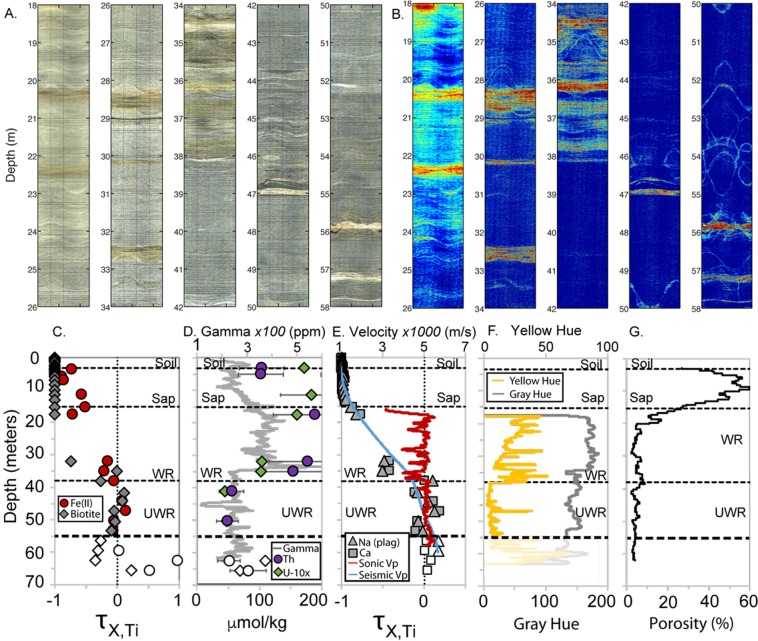
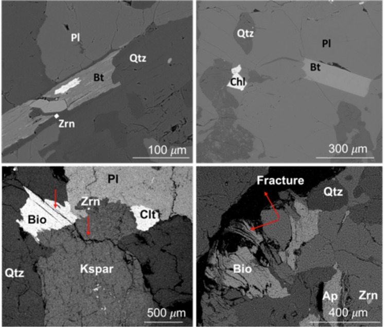
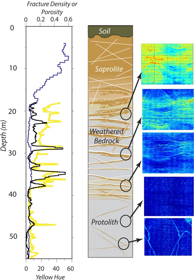
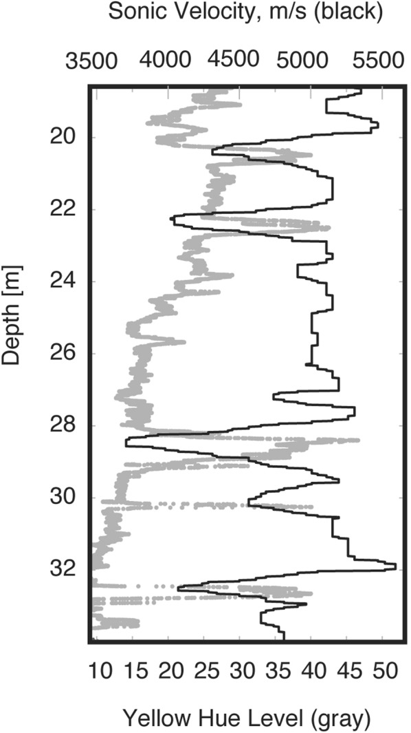
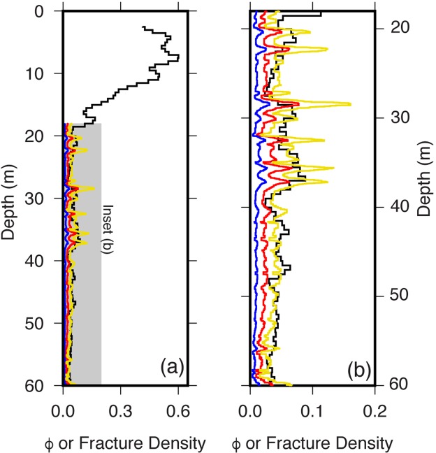
As bedrock weathers to regolith - defined here as weathered rock, saprolite, and soil - porosity grows, guides fluid flow, and liberates nutrients from minerals. Though vital to terrestrial life, the processes that transform bedrock into soil are poorly understood, especially in deep regolith, where direct observations are difficult. A 65-m-deep borehole in the Calhoun Critical Zone Observatory, South Carolina, provides unusual access to a complete weathering profile in an Appalachian granitoid. Co-located geophysical and geochemical datasets in the borehole show a remarkably consistent picture of linked chemical and physical weathering processes, acting over a 38-m-thick regolith divided into three layers: soil; porous, highly weathered saprolite; and weathered, fractured bedrock. The data document that major minerals (plagioclase and biotite) commence to weather at 38 m depth, 20 m below the base of saprolite, in deep, weathered rock where physical, chemical and optical properties abruptly change. The transition from saprolite to weathered bedrock is more gradational, over a depth range of 11-18 m. Chemical weathering increases steadily upward in the weathered bedrock, with intervals of more intense weathering along fractures, documenting the combined influence of time, reactive fluid transport, and the opening of fractures as rock is exhumed and transformed near Earth's surface.
当基岩风化形成风化层(这里定义为风化的岩石、腐泥土和土壤)时,孔隙度增加,引导流体流动,并从矿物质中释放养分。尽管这些将基岩转化为土壤的过程对陆地生命至关重要,但人们对其了解甚少,尤其是在难以进行直接观测的深部风化层。南卡罗来纳州卡尔霍恩关键带观测站一个65米深的钻孔,提供了难得的机会来获取阿巴拉契亚花岗岩类完整的风化剖面。钻孔中同时获取的地球物理和地球化学数据集显示,化学风化和物理风化过程相互关联,形成了一幅非常一致的图景,作用于一个38米厚的风化层,该风化层分为三层:土壤;多孔、高度风化的腐泥土;以及风化、破碎的基岩。数据表明,主要矿物(斜长石和黑云母)在深度38米处开始风化,即腐泥土底部以下20米处,在深部风化岩石中,其物理、化学和光学性质突然发生变化。从腐泥土到风化基岩的过渡更为渐变,深度范围为11 - 18米。在风化基岩中,化学风化向上稳步增加,沿裂缝有更强烈风化的间隔,这记录了时间、活性流体运移以及岩石在接近地球表面被挖掘和转化时裂缝张开的综合影响。