• 文献检索
  • 文档翻译
  • 深度研究
  • 学术资讯
  • Suppr Zotero 插件Zotero 插件
  • 邀请有礼
  • 套餐&价格
  • 历史记录
应用&插件
Suppr Zotero 插件Zotero 插件浏览器插件Mac 客户端Windows 客户端微信小程序
定价
高级版会员购买积分包购买API积分包
服务
文献检索文档翻译深度研究API 文档MCP 服务
关于我们
关于 Suppr公司介绍联系我们用户协议隐私条款
关注我们

Suppr 超能文献

核心技术专利:CN118964589B侵权必究
粤ICP备2023148730 号-1Suppr @ 2026

文献检索

告别复杂PubMed语法,用中文像聊天一样搜索,搜遍4000万医学文献。AI智能推荐,让科研检索更轻松。

立即免费搜索

文件翻译

保留排版,准确专业,支持PDF/Word/PPT等文件格式,支持 12+语言互译。

免费翻译文档

深度研究

AI帮你快速写综述,25分钟生成高质量综述,智能提取关键信息,辅助科研写作。

立即免费体验

基于 GNSS/LiDAR 的稀疏林区空中机器人导航。

GNSS/LiDAR-Based Navigation of an Aerial Robot in Sparse Forests.

机构信息

Graduate Program in Electrical Engineering, Universidade Federal de Minas Gerais (UFMG), Belo Horizonte-MG 31270-901, Brazil.

Department of Mechanical and Aerospace Engineering, West Virginia University, Morgantown, WV 26506, USA.

出版信息

Sensors (Basel). 2019 Sep 20;19(19):4061. doi: 10.3390/s19194061.

DOI:10.3390/s19194061
PMID:31547079
原文链接:https://pmc.ncbi.nlm.nih.gov/articles/PMC6806588/
Abstract

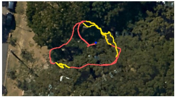
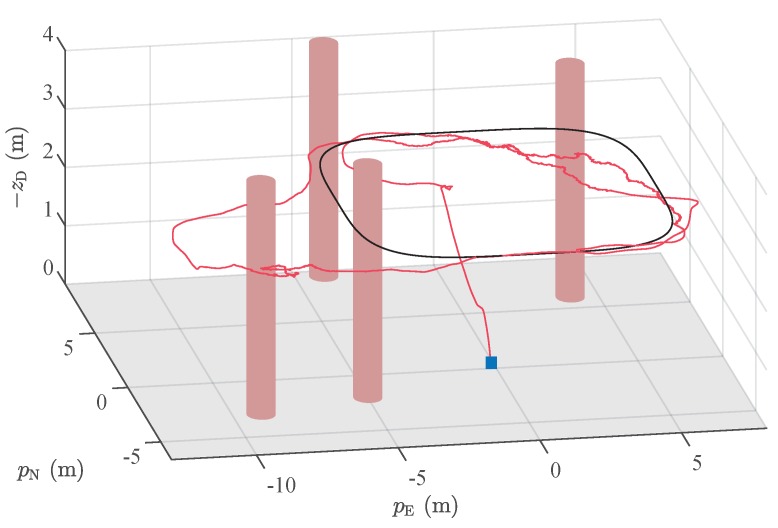
Autonomous navigation of unmanned vehicles in forests is a challenging task. In such environments, due to the canopies of the trees, information from Global Navigation Satellite Systems (GNSS) can be degraded or even unavailable. Also, because of the large number of obstacles, a previous detailed map of the environment is not practical. In this paper, we solve the complete navigation problem of an aerial robot in a sparse forest, where there is enough space for the flight and the GNSS signals can be sporadically detected. For localization, we propose a state estimator that merges information from GNSS, Attitude and Heading Reference Systems (AHRS), and odometry based on Light Detection and Ranging (LiDAR) sensors. In our LiDAR-based odometry solution, the trunks of the trees are used in a feature-based scan matching algorithm to estimate the relative movement of the vehicle. Our method employs a robust adaptive fusion algorithm based on the unscented Kalman filter. For motion control, we adopt a strategy that integrates a vector field, used to impose the main direction of the movement for the robot, with an optimal probabilistic planner, which is responsible for obstacle avoidance. Experiments with a quadrotor equipped with a planar LiDAR in an actual forest environment is used to illustrate the effectiveness of our approach.

摘要

无人车在森林中的自主导航是一项具有挑战性的任务。在这样的环境中,由于树冠的存在,全球导航卫星系统(GNSS)的信息可能会降级甚至不可用。此外,由于障碍物数量众多,之前详细的环境地图并不实用。在本文中,我们解决了在稀疏森林中飞行机器人的完整导航问题,其中有足够的飞行空间,并且可以偶尔检测到 GNSS 信号。对于定位,我们提出了一种状态估计器,该估计器融合了来自 GNSS、姿态和航向参考系统(AHRS)以及基于光检测和测距(LiDAR)传感器的里程计的信息。在我们基于 LiDAR 的里程计解决方案中,利用树木的树干在基于特征的扫描匹配算法中估计车辆的相对运动。我们的方法采用了一种基于无迹卡尔曼滤波器的鲁棒自适应融合算法。对于运动控制,我们采用了一种策略,该策略将用于为机器人施加主要运动方向的向量场与负责避免障碍物的最优概率规划器集成在一起。在实际森林环境中,配备平面 LiDAR 的四旋翼飞行器的实验用于说明我们方法的有效性。

https://cdn.ncbi.nlm.nih.gov/pmc/blobs/d136/6806588/68d1649524ac/sensors-19-04061-g014.jpg
https://cdn.ncbi.nlm.nih.gov/pmc/blobs/d136/6806588/27d03c085de2/sensors-19-04061-g001.jpg
https://cdn.ncbi.nlm.nih.gov/pmc/blobs/d136/6806588/ba01dbc41645/sensors-19-04061-g002.jpg
https://cdn.ncbi.nlm.nih.gov/pmc/blobs/d136/6806588/8e2a45b6f960/sensors-19-04061-g003.jpg
https://cdn.ncbi.nlm.nih.gov/pmc/blobs/d136/6806588/e599ee841b4e/sensors-19-04061-g004.jpg
https://cdn.ncbi.nlm.nih.gov/pmc/blobs/d136/6806588/d4465c5075ae/sensors-19-04061-g005.jpg
https://cdn.ncbi.nlm.nih.gov/pmc/blobs/d136/6806588/269ef7d55af6/sensors-19-04061-g006.jpg
https://cdn.ncbi.nlm.nih.gov/pmc/blobs/d136/6806588/d125cf54b9ab/sensors-19-04061-g007.jpg
https://cdn.ncbi.nlm.nih.gov/pmc/blobs/d136/6806588/1c6cf6d1ee5b/sensors-19-04061-g008.jpg
https://cdn.ncbi.nlm.nih.gov/pmc/blobs/d136/6806588/9ff23dd76b2d/sensors-19-04061-g009.jpg
https://cdn.ncbi.nlm.nih.gov/pmc/blobs/d136/6806588/dbd2ef5e467f/sensors-19-04061-g010.jpg
https://cdn.ncbi.nlm.nih.gov/pmc/blobs/d136/6806588/a5cbc97892a2/sensors-19-04061-g011.jpg
https://cdn.ncbi.nlm.nih.gov/pmc/blobs/d136/6806588/bf7e36bc1cea/sensors-19-04061-g012.jpg
https://cdn.ncbi.nlm.nih.gov/pmc/blobs/d136/6806588/4d48507d0cdc/sensors-19-04061-g013.jpg
https://cdn.ncbi.nlm.nih.gov/pmc/blobs/d136/6806588/68d1649524ac/sensors-19-04061-g014.jpg

相似文献

1
GNSS/LiDAR-Based Navigation of an Aerial Robot in Sparse Forests.基于 GNSS/LiDAR 的稀疏林区空中机器人导航。
Sensors (Basel). 2019 Sep 20;19(19):4061. doi: 10.3390/s19194061.
2
Improved LiDAR Probabilistic Localization for Autonomous Vehicles Using GNSS.使用全球导航卫星系统(GNSS)改进自动驾驶车辆的激光雷达概率定位
Sensors (Basel). 2020 Jun 2;20(11):3145. doi: 10.3390/s20113145.
3
Real-Time Onboard 3D State Estimation of an Unmanned Aerial Vehicle in Multi-Environments Using Multi-Sensor Data Fusion.基于多传感器数据融合的无人机在多环境中的实时机载三维状态估计
Sensors (Basel). 2020 Feb 9;20(3):919. doi: 10.3390/s20030919.
4
LiDAR Scan Matching Aided Inertial Navigation System in GNSS-Denied Environments.全球导航卫星系统(GNSS)受限环境下的激光雷达扫描匹配辅助惯性导航系统
Sensors (Basel). 2015 Jul 10;15(7):16710-28. doi: 10.3390/s150716710.
5
Pole-Like Object Extraction and Pole-Aided GNSS/IMU/LiDAR-SLAM System in Urban Area.城区中杆状物体提取及基于杆辅助的GNSS/IMU/LiDAR-SLAM系统
Sensors (Basel). 2020 Dec 13;20(24):7145. doi: 10.3390/s20247145.
6
A Robust Vehicle Localization Approach Based on GNSS/IMU/DMI/LiDAR Sensor Fusion for Autonomous Vehicles.一种基于GNSS/IMU/DMI/激光雷达传感器融合的用于自动驾驶车辆的稳健车辆定位方法。
Sensors (Basel). 2017 Sep 18;17(9):2140. doi: 10.3390/s17092140.
7
Differential GNSS and Vision-Based Tracking to Improve Navigation Performance in Cooperative Multi-UAV Systems.差分全球导航卫星系统与基于视觉的跟踪技术,以提升协同多无人机系统中的导航性能
Sensors (Basel). 2016 Dec 17;16(12):2164. doi: 10.3390/s16122164.
8
Practical Modeling of GNSS for Autonomous Vehicles in Urban Environments.在城市环境中为自动驾驶汽车进行实用的 GNSS 建模。
Sensors (Basel). 2019 Sep 29;19(19):4236. doi: 10.3390/s19194236.
9
Optical and Mass Flow Sensors for Aiding Vehicle Navigation in GNSS Denied Environment.用于在全球导航卫星系统(GNSS)信号受阻环境中辅助车辆导航的光学和质量流量传感器。
Sensors (Basel). 2020 Nov 17;20(22):6567. doi: 10.3390/s20226567.
10
Autonomous aerial obstacle avoidance using LiDAR sensor fusion.使用激光雷达传感器融合实现自主空中避障。
PLoS One. 2023 Jun 28;18(6):e0287177. doi: 10.1371/journal.pone.0287177. eCollection 2023.

引用本文的文献

1
Parallel Sensor-Space Lattice Planner for Real-Time Obstacle Avoidance.用于实时避障的并行传感器空间晶格规划器
Sensors (Basel). 2022 Jun 24;22(13):4770. doi: 10.3390/s22134770.
2
QuadNet: A Hybrid Framework for Quadrotor Dead Reckoning.四旋翼飞行器航位推算的混合框架 QuadNet
Sensors (Basel). 2022 Feb 13;22(4):1426. doi: 10.3390/s22041426.
3
Neural network assisted Kalman filter for INS/UWB integrated seamless quadrotor localization.用于INS/UWB集成无缝四旋翼定位的神经网络辅助卡尔曼滤波器

本文引用的文献

1
Quaternion-Based Robust Attitude Estimation Using an Adaptive Unscented Kalman Filter.基于四元数的自适应无迹卡尔曼滤波器鲁棒姿态估计
Sensors (Basel). 2019 May 23;19(10):2372. doi: 10.3390/s19102372.
2
A Multi-Sensor Fusion MAV State Estimation from Long-Range Stereo, IMU, GPS and Barometric Sensors.基于远距离立体视觉、惯性测量单元、全球定位系统和气压传感器的多传感器融合微型飞行器状态估计
Sensors (Basel). 2016 Dec 22;17(1):11. doi: 10.3390/s17010011.
3
LiDAR Scan Matching Aided Inertial Navigation System in GNSS-Denied Environments.全球导航卫星系统(GNSS)受限环境下的激光雷达扫描匹配辅助惯性导航系统
PeerJ Comput Sci. 2021 Jul 14;7:e630. doi: 10.7717/peerj-cs.630. eCollection 2021.
Sensors (Basel). 2015 Jul 10;15(7):16710-28. doi: 10.3390/s150716710.