• 文献检索
  • 文档翻译
  • 深度研究
  • 学术资讯
  • Suppr Zotero 插件Zotero 插件
  • 邀请有礼
  • 套餐&价格
  • 历史记录
应用&插件
Suppr Zotero 插件Zotero 插件浏览器插件Mac 客户端Windows 客户端微信小程序
定价
高级版会员购买积分包购买API积分包
服务
文献检索文档翻译深度研究API 文档MCP 服务
关于我们
关于 Suppr公司介绍联系我们用户协议隐私条款
关注我们

Suppr 超能文献

核心技术专利:CN118964589B侵权必究
粤ICP备2023148730 号-1Suppr @ 2026

文献检索

告别复杂PubMed语法,用中文像聊天一样搜索,搜遍4000万医学文献。AI智能推荐,让科研检索更轻松。

立即免费搜索

文件翻译

保留排版,准确专业,支持PDF/Word/PPT等文件格式,支持 12+语言互译。

免费翻译文档

深度研究

AI帮你快速写综述,25分钟生成高质量综述,智能提取关键信息,辅助科研写作。

立即免费体验

确定亚马逊森林与 2000 年 GFC 数据树冠覆盖的界限阈值。

Determining a Threshold to Delimit the Amazonian Forests from the Tree Canopy Cover 2000 GFC Data.

机构信息

Divisão de Sensoriamento Remoto, Instituto Nacional de Pesquisas Espaciais, São José dos Campos - SP, Brazil.

Department of Geographical Sciences, University of Maryland, College Park, Maryland, MD 20740, USA.

出版信息

Sensors (Basel). 2019 Nov 18;19(22):5020. doi: 10.3390/s19225020.

DOI:10.3390/s19225020
PMID:31752073
原文链接:https://pmc.ncbi.nlm.nih.gov/articles/PMC6891484/
Abstract

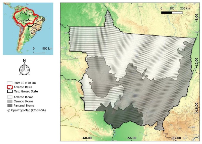
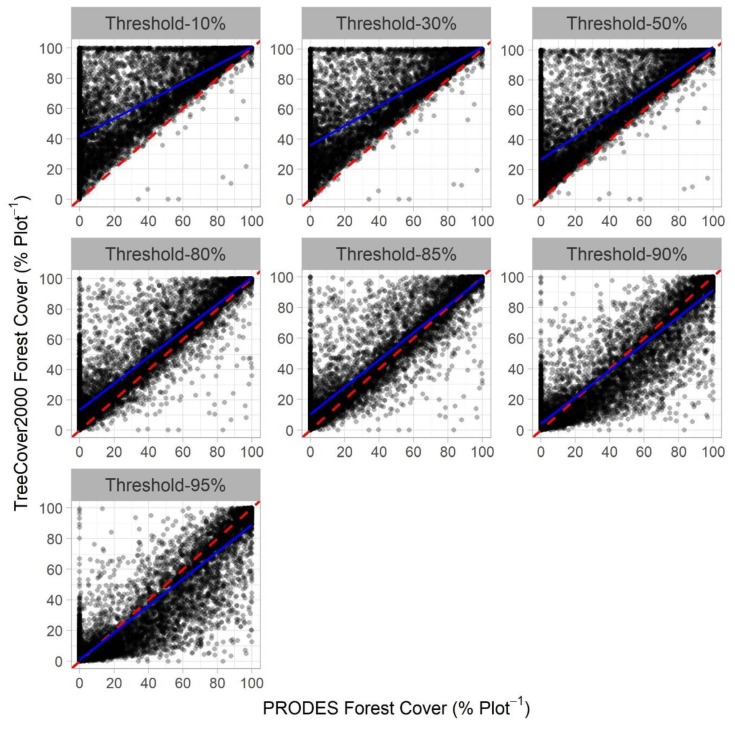
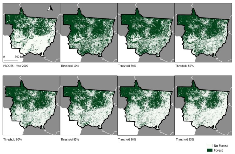
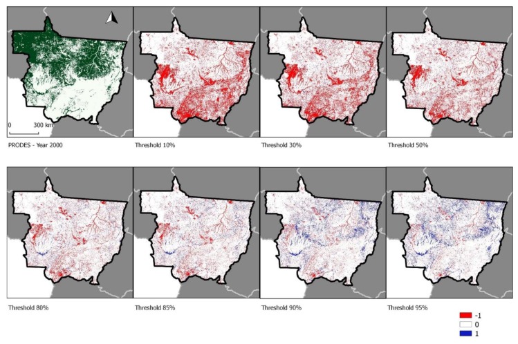
Open global forest cover data can be a critical component for Reducing Emissions from Deforestation and Forest Degradation (REDD+) policies. In this work, we determine the best threshold, compatible with the official Brazilian dataset, for establishing a forest mask cover within the Amazon basin for the year 2000 using the Tree Canopy Cover 2000 GFC product. We compared forest cover maps produced using several thresholds (10%, 30%, 50%, 80%, 85%, 90%, and 95%) with a forest cover map for the same year from the Brazilian Amazon Deforestation Monitoring Project (PRODES) data, produced by the National Institute for Space Research (INPE). We also compared the forest cover classifications indicated by each of these maps to 2550 independently assessed Landsat pixels for the year 2000, providing an accuracy assessment for each of these map products. We found that thresholds of 80% and 85% best matched with the PRODES data. Consequently, we recommend using an 80% threshold for the Tree Canopy Cover 2000 data for assessing forest cover in the Amazon basin.

摘要

开放的全球森林覆盖数据可以成为减少毁林和森林退化所致排放(REDD+)政策的一个关键组成部分。在这项工作中,我们使用 2000 年树冠覆盖物产品,确定了与官方巴西数据集兼容的最佳阈值,以便在亚马逊流域内建立 2000 年的森林掩模覆盖。我们将使用几种阈值(10%、30%、50%、80%、85%、90%和 95%)生成的森林覆盖图与巴西亚马逊毁林监测项目(PRODES)同年的森林覆盖图进行了比较,该图由国家空间研究所(INPE)生成。我们还将每个地图的森林覆盖分类与 2000 年的 2550 个独立评估的陆地卫星像素进行了比较,为每个地图产品提供了准确性评估。我们发现,80%和 85%的阈值与 PRODES 数据最为匹配。因此,我们建议在评估亚马逊流域的森林覆盖时,对 2000 年树冠覆盖物数据使用 80%的阈值。

https://cdn.ncbi.nlm.nih.gov/pmc/blobs/2156/6891484/82ff8133d97d/sensors-19-05020-g004.jpg
https://cdn.ncbi.nlm.nih.gov/pmc/blobs/2156/6891484/7e0850b9d4a3/sensors-19-05020-g001.jpg
https://cdn.ncbi.nlm.nih.gov/pmc/blobs/2156/6891484/cd8814d913c0/sensors-19-05020-g002.jpg
https://cdn.ncbi.nlm.nih.gov/pmc/blobs/2156/6891484/0bb5e882f221/sensors-19-05020-g003.jpg
https://cdn.ncbi.nlm.nih.gov/pmc/blobs/2156/6891484/82ff8133d97d/sensors-19-05020-g004.jpg

相似文献

1
Determining a Threshold to Delimit the Amazonian Forests from the Tree Canopy Cover 2000 GFC Data.确定亚马逊森林与 2000 年 GFC 数据树冠覆盖的界限阈值。
Sensors (Basel). 2019 Nov 18;19(22):5020. doi: 10.3390/s19225020.
2
Biases and limitations of Global Forest Change and author-generated land cover maps in detecting deforestation in the Amazon.全球森林变化及作者生成的土地覆盖图在探测亚马逊地区森林砍伐中的偏差和局限性。
PLoS One. 2022 Jul 6;17(7):e0268970. doi: 10.1371/journal.pone.0268970. eCollection 2022.
3
Evidence that a national REDD+ program reduces tree cover loss and carbon emissions in a high forest cover, low deforestation country.有证据表明,在一个森林覆盖率高、森林砍伐率低的国家,国家 REDD+ 计划减少了森林覆盖的损失和碳排放。
Proc Natl Acad Sci U S A. 2019 Dec 3;116(49):24492-24499. doi: 10.1073/pnas.1904027116. Epub 2019 Nov 18.
4
Rethinking forest monitoring for more meaningful global forest landscape change assessments.重新思考森林监测,以更有意义地评估全球森林景观变化。
J Environ Manage. 2022 Sep 1;317:115478. doi: 10.1016/j.jenvman.2022.115478. Epub 2022 Jun 7.
5
Assessing aboveground tropical forest biomass using Google Earth canopy images.利用谷歌地球冠层图像评估热带森林地上生物量。
Ecol Appl. 2012 Apr;22(3):993-1003. doi: 10.1890/11-1606.1.
6
Satellite-based estimates reveal widespread forest degradation in the Amazon.卫星估算显示亚马逊地区广泛存在森林退化现象。
Glob Chang Biol. 2020 May;26(5):2956-2969. doi: 10.1111/gcb.15029. Epub 2020 Mar 6.
7
Sixteen hundred years of increasing tree cover prior to modern deforestation in Southern Amazon and Central Brazilian savannas.在现代毁林之前,南亚马逊和巴西中部热带稀树草原的树木覆盖面积增加了 1600 年。
Glob Chang Biol. 2021 Jan;27(1):136-150. doi: 10.1111/gcb.15382. Epub 2020 Oct 31.
8
Types and rates of forest disturbance in Brazilian Legal Amazon, 2000-2013.2000-2013 年巴西法定亚马孙地区森林干扰的类型和速率。
Sci Adv. 2017 Apr 12;3(4):e1601047. doi: 10.1126/sciadv.1601047. eCollection 2017 Apr.
9
Dispersal limitation induces long-term biomass collapse in overhunted Amazonian forests.扩散限制导致过度捕猎的亚马逊森林长期生物量崩溃。
Proc Natl Acad Sci U S A. 2016 Jan 26;113(4):892-7. doi: 10.1073/pnas.1516525113.
10
Land use/land cover (LULC) analysis (2009-2019) with Google Earth Engine and 2030 prediction using Markov-CA in the Rondônia State, Brazil.土地利用/土地覆盖(LULC)分析(2009-2019 年),使用 Google Earth Engine 和 Markov-CA 进行巴西朗多尼亚州 2030 年预测。
Environ Monit Assess. 2021 Mar 30;193(4):239. doi: 10.1007/s10661-021-09016-y.

引用本文的文献

1
Persistent collapse of biomass in Amazonian forest edges following deforestation leads to unaccounted carbon losses.亚马孙森林边缘的森林砍伐后生物质持续崩溃,导致碳损失无法计算。
Sci Adv. 2020 Sep 30;6(40). doi: 10.1126/sciadv.aaz8360. Print 2020 Sep.
2
Benchmark maps of 33 years of secondary forest age for Brazil.巴西 33 年次生林龄基准图。
Sci Data. 2020 Aug 14;7(1):269. doi: 10.1038/s41597-020-00600-4.

本文引用的文献

1
Global patterns of tropical forest fragmentation.全球热带森林破碎化格局。
Nature. 2018 Feb 22;554(7693):519-522. doi: 10.1038/nature25508. Epub 2018 Feb 14.
2
21st Century drought-related fires counteract the decline of Amazon deforestation carbon emissions.二十一世纪与干旱相关的火灾抵消了亚马孙毁林碳排放的减少。
Nat Commun. 2018 Feb 13;9(1):536. doi: 10.1038/s41467-017-02771-y.
3
Pervasive Rise of Small-scale Deforestation in Amazonia.亚马孙地区小规模毁林现象普遍增多。
Sci Rep. 2018 Jan 25;8(1):1600. doi: 10.1038/s41598-018-19358-2.
4
An integrated remote sensing and GIS approach for monitoring areas affected by selective logging: A case study in northern Mato Grosso, Brazilian Amazon.一种用于监测受选择性采伐影响区域的综合遥感与地理信息系统方法:以巴西亚马逊州马托格罗索北部为例
Int J Appl Earth Obs Geoinf. 2017 Sep;61:70-80. doi: 10.1016/j.jag.2017.05.001.
5
Climate drivers of the Amazon forest greening.亚马逊森林绿化的气候驱动因素。
PLoS One. 2017 Jul 14;12(7):e0180932. doi: 10.1371/journal.pone.0180932. eCollection 2017.
6
Types and rates of forest disturbance in Brazilian Legal Amazon, 2000-2013.2000-2013 年巴西法定亚马孙地区森林干扰的类型和速率。
Sci Adv. 2017 Apr 12;3(4):e1601047. doi: 10.1126/sciadv.1601047. eCollection 2017 Apr.
7
High resolution analysis of tropical forest fragmentation and its impact on the global carbon cycle.高分辨率分析热带森林破碎化及其对全球碳循环的影响。
Nat Commun. 2017 Mar 17;8:14855. doi: 10.1038/ncomms14855.
8
High-resolution mapping of global surface water and its long-term changes.高分辨率绘制全球地表水及其长期变化图。
Nature. 2016 Dec 15;540(7633):418-422. doi: 10.1038/nature20584. Epub 2016 Dec 7.
9
Fine-scale malaria risk mapping from routine aggregated case data.利用常规汇总病例数据进行精细尺度的疟疾风险绘图。
Malar J. 2014 Nov 3;13:421. doi: 10.1186/1475-2875-13-421.
10
Environmental change and the carbon balance of Amazonian forests.环境变化与亚马孙森林的碳平衡。
Biol Rev Camb Philos Soc. 2014 Nov;89(4):913-31. doi: 10.1111/brv.12088. Epub 2014 Feb 20.