Department of Marine Physics and Ocean Climate, National Oceanography Centre, Liverpool L3 5DA, United Kingdom;
Department of Oceanography and Global Change, Mediterranean Institute for Advanced Studies, Spanish National Research Council and University of the Balearic Islands (CSIC-UIB), Esporles 07190, Spain.
Proc Natl Acad Sci U S A. 2020 Jan 28;117(4):1877-1883. doi: 10.1073/pnas.1913049117. Epub 2020 Jan 13.
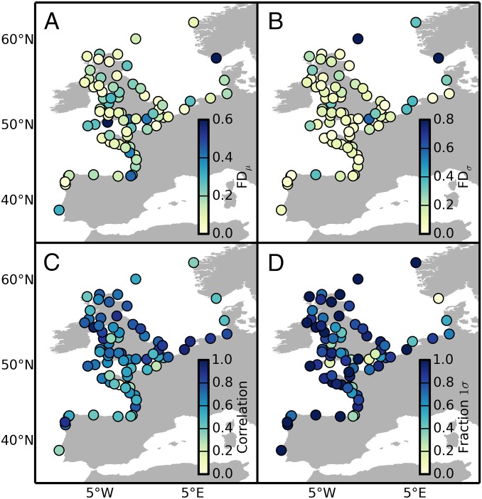
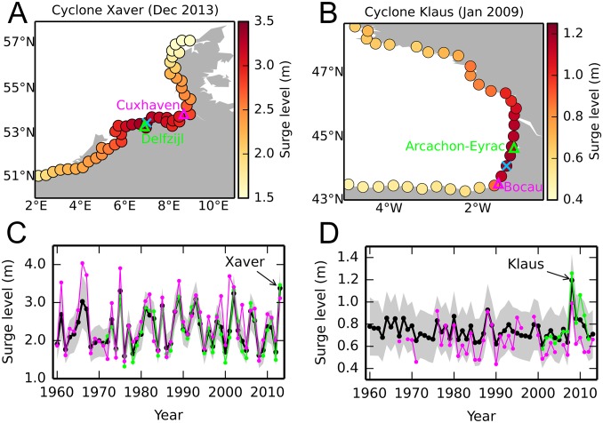
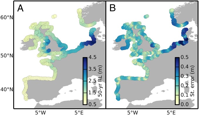
Extreme sea levels are a significant threat to life, property, and the environment. These threats are managed by coastal planers through the implementation of risk mitigation strategies. Central to such strategies is knowledge of extreme event probabilities. Typically, these probabilities are estimated by fitting a suitable distribution to the observed extreme data. Estimates, however, are often uncertain due to the small number of extreme events in the tide gauge record and are only available at gauged locations. This restricts our ability to implement cost-effective mitigation. A remarkable fact about sea-level extremes is the existence of spatial dependences, yet the vast majority of studies to date have analyzed extremes on a site-by-site basis. Here we demonstrate that spatial dependences can be exploited to address the limitations posed by the spatiotemporal sparseness of the observational record. We achieve this by pooling all of the tide gauge data together through a Bayesian hierarchical model that describes how the distribution of surge extremes varies in time and space. Our approach has two highly desirable advantages: 1) it enables sharing of information across data sites, with a consequent drastic reduction in estimation uncertainty; 2) it permits interpolation of both the extreme values and the extreme distribution parameters at any arbitrary ungauged location. Using our model, we produce an observation-based probabilistic reanalysis of surge extremes covering the entire Atlantic and North Sea coasts of Europe for the period 1960-2013.
极端海平面是对生命、财产和环境的重大威胁。沿海规划者通过实施风险缓解策略来管理这些威胁。此类策略的核心是了解极端事件的概率。通常,这些概率是通过将合适的分布拟合到观测到的极端数据来估计的。然而,由于潮汐计记录中的极端事件数量较少,因此估计往往存在不确定性,并且仅在测量位置可用。这限制了我们实施成本效益高的缓解措施的能力。海平面极端情况的一个显著事实是存在空间依赖性,但迄今为止,绝大多数研究都基于站点对极端情况进行了分析。在这里,我们证明可以利用空间依赖性来解决观测记录时空稀疏性带来的限制。我们通过使用贝叶斯层次模型将所有潮汐计数据汇总在一起来实现这一点,该模型描述了浪涌极值在时间和空间上的分布如何变化。我们的方法有两个非常理想的优势:1)它能够在数据站点之间共享信息,从而大大降低估计不确定性;2)它允许在任何任意未测量的位置插值极值和极值分布参数。使用我们的模型,我们生成了 1960-2013 年期间覆盖整个欧洲大西洋和北海海岸的浪涌极值的基于观测的概率再分析。