Marine Science Institute (ICM-CSIC), 08003 Barcelona, Spain.
Stazione Zoologica Anton Dohrn, 80122 Naples, Italy.
Sensors (Basel). 2020 Mar 21;20(6):1751. doi: 10.3390/s20061751.
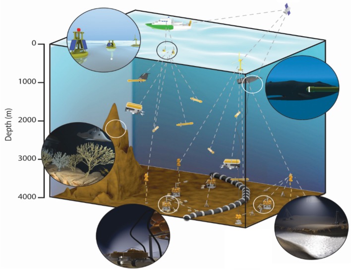
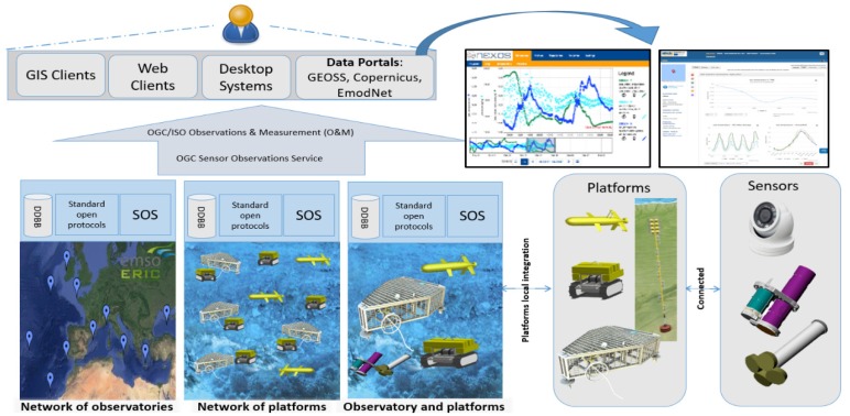
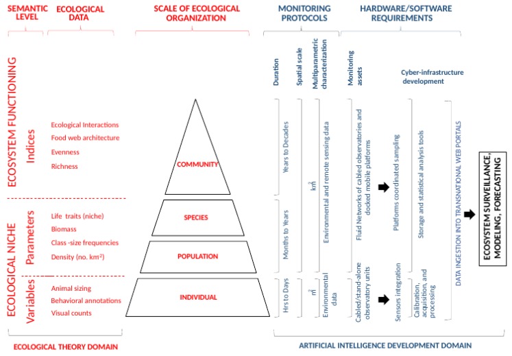
Measuring biodiversity simultaneously in different locations, at different temporal scales, and over wide spatial scales is of strategic importance for the improvement of our understanding of the functioning of marine ecosystems and for the conservation of their biodiversity. Monitoring networks of cabled observatories, along with other docked autonomous systems (e.g., Remotely Operated Vehicles [ROVs], Autonomous Underwater Vehicles [AUVs], and crawlers), are being conceived and established at a spatial scale capable of tracking energy fluxes across benthic and pelagic compartments, as well as across geographic ecotones. At the same time, optoacoustic imaging is sustaining an unprecedented expansion in marine ecological monitoring, enabling the acquisition of new biological and environmental data at an appropriate spatiotemporal scale. At this stage, one of the main problems for an effective application of these technologies is the processing, storage, and treatment of the acquired complex ecological information. Here, we provide a conceptual overview on the technological developments in the multiparametric generation, storage, and automated hierarchic treatment of biological and environmental information required to capture the spatiotemporal complexity of a marine ecosystem. In doing so, we present a pipeline of ecological data acquisition and processing in different steps and prone to automation. We also give an example of population biomass, community richness and biodiversity data computation (as indicators for ecosystem functionality) with an Internet Operated Vehicle (a mobile crawler). Finally, we discuss the software requirements for that automated data processing at the level of cyber-infrastructures with sensor calibration and control, data banking, and ingestion into large data portals.
同时在不同地点、不同时间尺度和广泛的空间尺度上测量生物多样性,对于提高我们对海洋生态系统功能的理解和保护其生物多样性具有战略重要性。沿着海底观测网络的电缆,以及其他停泊的自治系统(例如,遥控潜水器 [ROV]、自主水下航行器 [AUV] 和爬行器),正在构想和建立在一个能够跟踪海底和浮游生物区系以及地理生态过渡带之间能量通量的空间尺度上。与此同时,光声成像是海洋生态监测的一个前所未有的扩展,使人们能够以适当的时空尺度获取新的生物和环境数据。在现阶段,有效应用这些技术的主要问题之一是处理、存储和处理所获取的复杂生态信息。在这里,我们提供了一个概念概述,介绍了多参数生成、存储和自动层次处理生物和环境信息所需的技术发展,以捕捉海洋生态系统的时空复杂性。在这样做的过程中,我们展示了一个在不同步骤和易于自动化的生态数据采集和处理的流水线。我们还给出了一个使用互联网操作的车辆(移动爬行器)计算生物量、群落丰富度和生物多样性数据(作为生态系统功能的指标)的示例。最后,我们讨论了在具有传感器校准和控制、数据库和大数据门户摄入功能的网络基础设施级别进行自动数据处理的软件要求。