Aix Marseille Univ, IRD, INSERM, SESSTIM, Marseille, France.
Ecole des Hautes Etudes en Santé Publique, Rennes, France.
BMC Infect Dis. 2020 Jun 17;20(1):424. doi: 10.1186/s12879-020-05145-w.
In malaria endemic areas, identifying spatio-temporal hotspots is becoming an important element of innovative control strategies targeting transmission bottlenecks. The aim of this work was to describe the spatio-temporal variation of malaria hotspots in central Senegal and to identify the meteorological, environmental, and preventive factors that influence this variation.
This study analysed the weekly incidence of malaria cases recorded from 2008 to 2012 in 575 villages of central Senegal (total population approximately 500,000) as part of a trial of seasonal malaria chemoprevention (SMC). Data on weekly rainfall and annual vegetation types were obtained for each village through remote sensing. The time series of weekly malaria incidence for the entire study area was divided into periods of high and low transmission using change-point analysis. Malaria hotspots were detected during each transmission period with the SaTScan method. The effects of rainfall, vegetation type, and SMC intervention on the spatio-temporal variation of malaria hotspots were assessed using a General Additive Mixed Model.
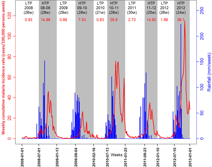
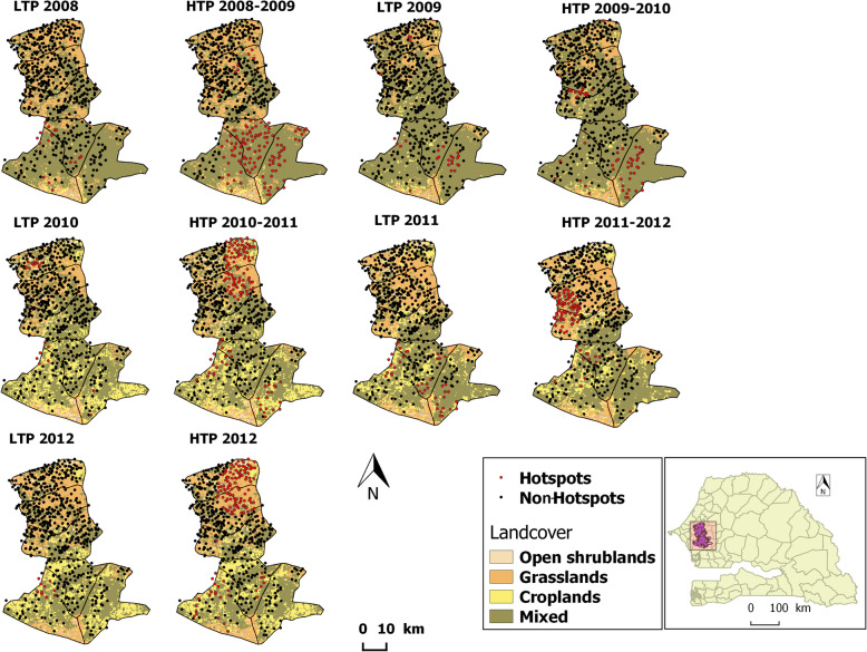
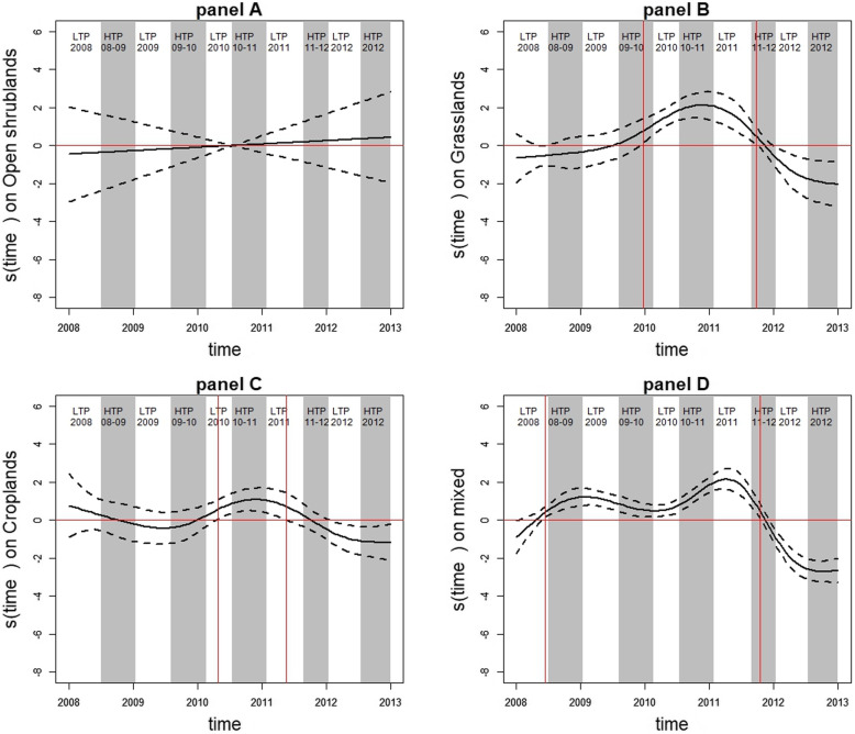
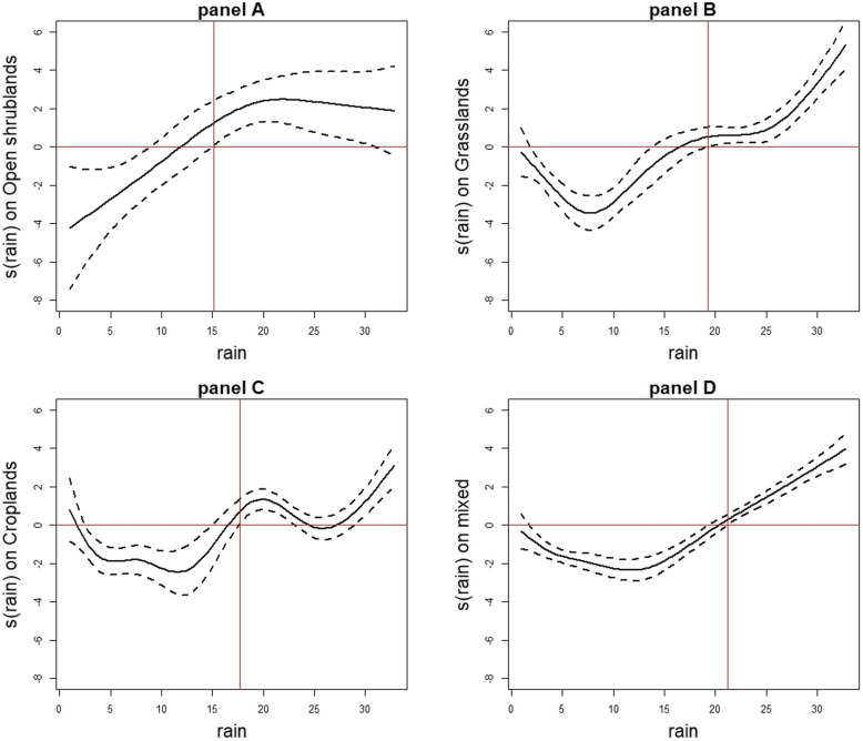
The malaria incidence for the entire area varied between 0 and 115.34 cases/100,000 person weeks during the study period. During high transmission periods, the cumulative malaria incidence rate varied between 7.53 and 38.1 cases/100,000 person-weeks, and the number of hotspot villages varied between 62 and 147. During low transmission periods, the cumulative malaria incidence rate varied between 0.83 and 2.73 cases/100,000 person-weeks, and the number of hotspot villages varied between 10 and 43. Villages with SMC were less likely to be hotspots (OR = 0.48, IC95%: 0.33-0.68). The association between rainfall and hotspot status was non-linear and depended on both vegetation type and amount of rainfall. The association between village location in the study area and hotspot status was also shown.
In our study, malaria hotspots varied over space and time according to a combination of meteorological, environmental, and preventive factors. By taking into consideration the environmental and meteorological characteristics common to all hotspots, monitoring of these factors could lead targeted public health interventions at the local level. Moreover, spatial hotspots and foci of malaria persisting during LTPs need to be further addressed.
The data used in this work were obtained from a clinical trial registered on July 10, 2008 at www.clinicaltrials.gov under NCT00712374.
在疟疾流行地区,识别时空热点正成为针对传播瓶颈的创新控制策略的重要组成部分。本研究旨在描述塞内加尔中部疟疾热点的时空变化,并确定影响这种变化的气象、环境和预防因素。
本研究分析了 2008 年至 2012 年在塞内加尔中部 575 个村庄(总人口约 50 万)记录的每周疟疾病例数据,这些村庄是季节性疟疾化学预防(SMC)试验的一部分。通过遥感获得每个村庄每周的降雨量和年度植被类型数据。使用断点分析将整个研究区域的每周疟疾发病率时间序列分为高传播期和低传播期。在每个传播期内,使用 SaTScan 方法检测疟疾热点。使用广义加性混合模型评估降雨量、植被类型和 SMC 干预对疟疾热点时空变化的影响。
整个地区的疟疾发病率在研究期间在 0 到 115.34 例/100,000 人周之间变化。在高传播期,累积疟疾发病率在 7.53 至 38.1 例/100,000 人周之间变化,热点村庄数量在 62 至 147 个之间变化。在低传播期,累积疟疾发病率在 0.83 至 2.73 例/100,000 人周之间变化,热点村庄数量在 10 至 43 个之间变化。接受 SMC 的村庄不太可能成为热点(OR=0.48,95%CI:0.33-0.68)。降雨量与热点状态之间的关系是非线性的,取决于植被类型和降雨量。还显示了村庄在研究区域中的位置与热点状态之间的关系。
在我们的研究中,疟疾热点根据气象、环境和预防因素的组合在空间和时间上发生变化。通过考虑所有热点共有的环境和气象特征,可以在当地层面进行有针对性的公共卫生干预。此外,需要进一步解决 LTP 期间持续存在的空间热点和疟疾焦点问题。
本研究中使用的数据来自于 2008 年 7 月 10 日在 www.clinicaltrials.gov 上注册的一项临床试验,注册号为 NCT00712374。