Aix Marseille Univ, INSERM, IRD, SESSTIM UMR1252 Sciences Economiques & Sociales de la Santé & Traitement de l'Information Médicale, Marseille, France.
Embassy of Japan in the Republic of Guinea, Conakry, Guinea.
Malar J. 2018 Apr 2;17(1):138. doi: 10.1186/s12936-018-2280-y.
Given the scarcity of resources in developing countries, malaria treatment requires new strategies that target specific populations, time periods and geographical areas. While the spatial pattern of malaria transmission is known to vary depending on local conditions, its temporal evolution has yet to be evaluated. The aim of this study was to determine the spatio-temporal dynamic of malaria in the central region of Burkina Faso, taking into account meteorological factors.
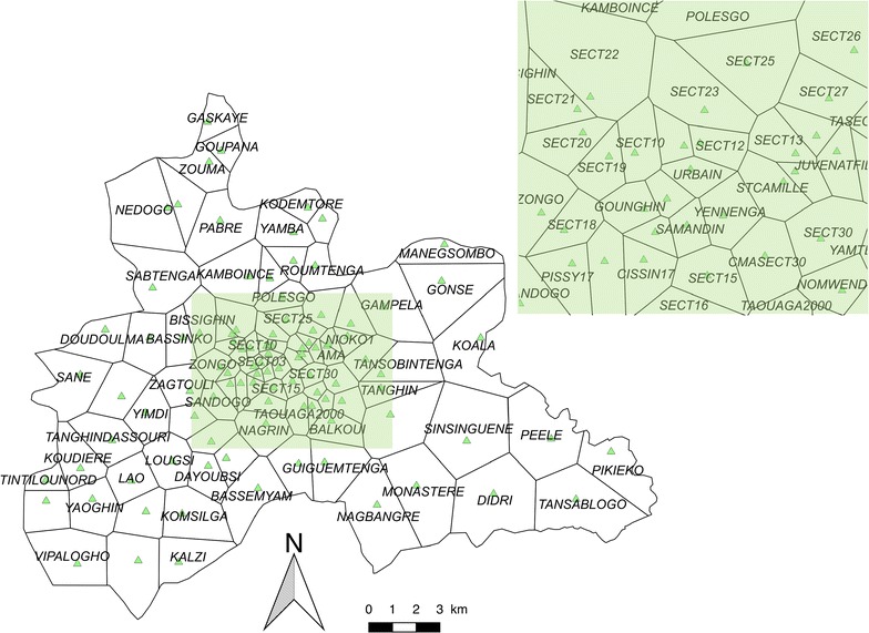
Drawing on national databases, 101 health areas were studied from 2011 to 2015, together with weekly meteorological data (temperature, number of rain events, rainfall, humidity, wind speed). Meteorological factors were investigated using a principal component analysis (PCA) to reduce dimensions and avoid collinearities. The Box-Jenkins ARIMA model was used to test the stationarity of the time series. The impact of meteorological factors on malaria incidence was measured with a general additive model. A change-point analysis was performed to detect malaria transmission periods. For each transmission period, malaria incidence was mapped and hotspots were identified using spatial cluster detection.
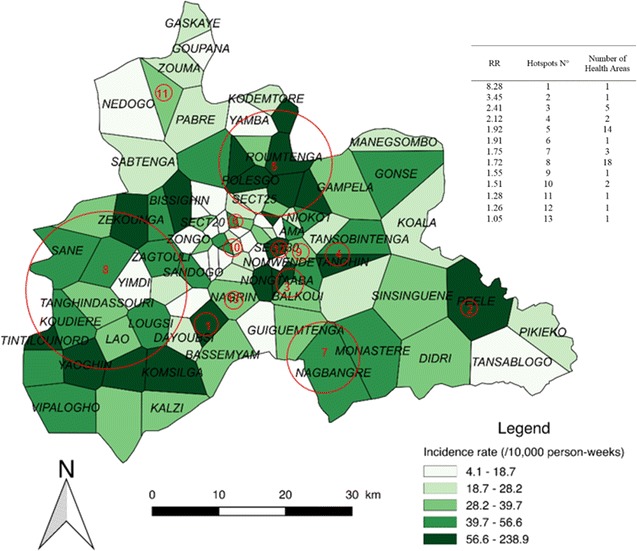
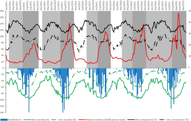
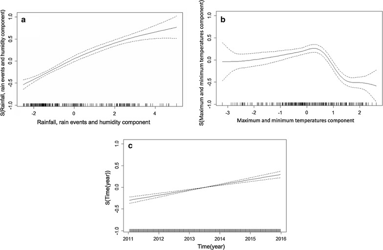
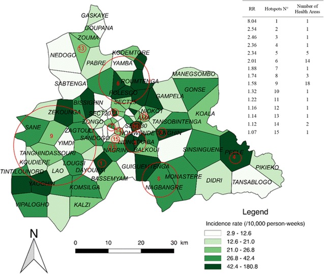
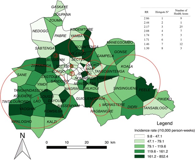
Malaria incidence never went below 13.7 cases/10,000 person-weeks. The first and second PCA components (constituted by rain/humidity and temperatures, respectively) were correlated with malaria incidence with a lag of 2 weeks. The impact of temperature was significantly non-linear: malaria incidence increased with temperature but declined sharply with high temperature. A significant positive linear trend was found for the entire time period. Three transmission periods were detected: low (16.8-29.9 cases/10,000 person-weeks), high (51.7-84.8 cases/10,000 person-weeks), and intermediate (26.7-32.2 cases/10,000 person-weeks). The location of clusters identified as high risk varied little across transmission periods.
This study highlighted the spatial variability and relative temporal stability of malaria incidence around the capital Ouagadougou, in the central region of Burkina Faso. Despite increasing efforts in fighting the disease, malaria incidence remained high and increased over the period of study. Hotspots, particularly those detected for low transmission periods, should be investigated further to uncover the local environmental and behavioural factors of transmission, and hence to allow for the development of better targeted control strategies.
发展中国家资源稀缺,因此疟疾治疗需要针对特定人群、时间和地理区域的新策略。虽然疟疾传播的空间模式已知会因当地条件而异,但它的时间演变尚未得到评估。本研究旨在考虑气象因素,确定布基纳法索中部地区疟疾的时空动态。
本研究利用国家数据库,对 2011 年至 2015 年的 101 个卫生区进行了研究,同时还收集了每周的气象数据(温度、降雨事件数、降雨量、湿度、风速)。使用主成分分析(PCA)来研究气象因素,以减少维度并避免共线性。采用 Box-Jenkins ARIMA 模型来检验时间序列的平稳性。采用广义加性模型来衡量气象因素对疟疾发病率的影响。采用变化点分析来检测疟疾传播期。对于每个传播期,通过空间聚类检测来绘制疟疾发病率图并识别热点。
疟疾发病率从未低于 13.7 例/10000 人周。第一和第二主成分(分别由降雨/湿度和温度组成)与疟疾发病率相关,滞后时间为 2 周。温度的影响呈显著非线性:随着温度升高,疟疾发病率增加,但随着高温急剧下降。整个时间段都发现了显著的正线性趋势。共检测到三个传播期:低(16.8-29.9 例/10000 人周)、高(51.7-84.8 例/10000 人周)和中(26.7-32.2 例/10000 人周)。不同传播期识别出的高风险集群位置变化不大。
本研究强调了布基纳法索中部瓦加杜古周边疟疾发病率的空间变异性和相对时间稳定性。尽管在防治疟疾方面做出了越来越多的努力,但疟疾发病率仍然很高,并在研究期间有所增加。应进一步调查热点地区,特别是那些在低传播期发现的热点地区,以揭示传播的局部环境和行为因素,从而制定更好的有针对性的控制策略。