• 文献检索
  • 文档翻译
  • 深度研究
  • 学术资讯
  • Suppr Zotero 插件Zotero 插件
  • 邀请有礼
  • 套餐&价格
  • 历史记录
应用&插件
Suppr Zotero 插件Zotero 插件浏览器插件Mac 客户端Windows 客户端微信小程序
定价
高级版会员购买积分包购买API积分包
服务
文献检索文档翻译深度研究API 文档MCP 服务
关于我们
关于 Suppr公司介绍联系我们用户协议隐私条款
关注我们

Suppr 超能文献

核心技术专利:CN118964589B侵权必究
粤ICP备2023148730 号-1Suppr @ 2026

文献检索

告别复杂PubMed语法,用中文像聊天一样搜索,搜遍4000万医学文献。AI智能推荐,让科研检索更轻松。

立即免费搜索

文件翻译

保留排版,准确专业,支持PDF/Word/PPT等文件格式,支持 12+语言互译。

免费翻译文档

深度研究

AI帮你快速写综述,25分钟生成高质量综述,智能提取关键信息,辅助科研写作。

立即免费体验

利用 Sentinel-1/2 和 COSMO-SkyMed 从太空揭示叙利亚博斯拉教科文组织遗址和塞吉欧波利斯鲜为人知的 2018 年洪水情况。

Poorly known 2018 floods in Bosra UNESCO site and Sergiopolis in Syria unveiled from space using Sentinel-1/2 and COSMO-SkyMed.

机构信息

Italian Space Agency (ASI), Via del Politecnico snc, 00133, Rome, Italy.

出版信息

Sci Rep. 2020 Jul 23;10(1):12307. doi: 10.1038/s41598-020-69181-x.

DOI:10.1038/s41598-020-69181-x
PMID:32704162
原文链接:https://pmc.ncbi.nlm.nih.gov/articles/PMC7378183/
Abstract

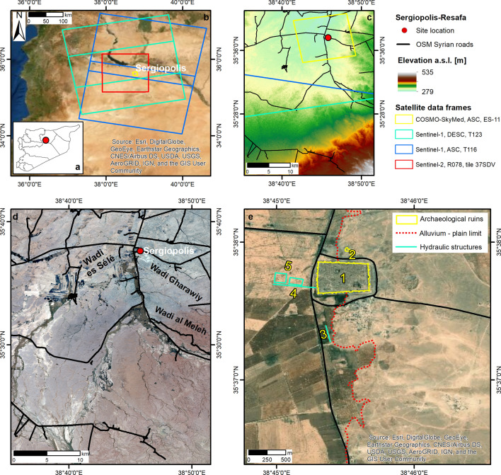
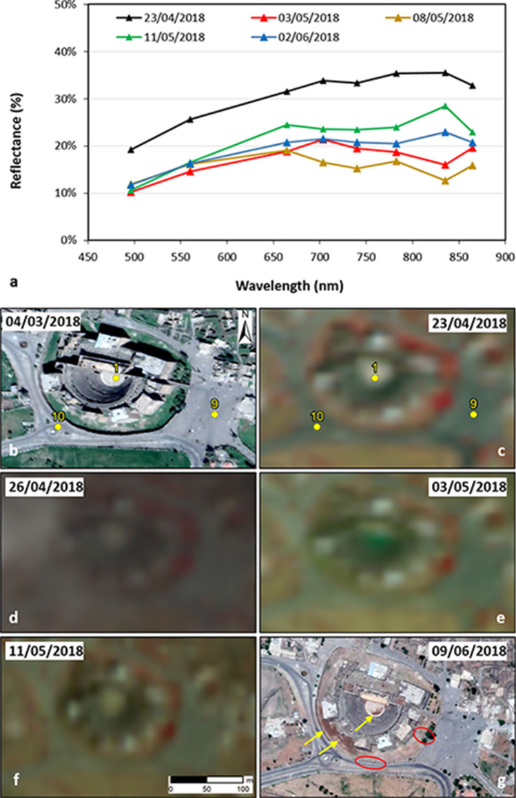
The instability situation affecting the Middle East poses threats to preservation of cultural heritage. Mapping efforts based on satellite imagery currently concentrate more on recording human-induced damage than impacts of unforeseen natural events (e.g. floods). In 2018, the UNESCO World Heritage Site of Bosra and the landscape of Sergiopolis-Resafa in Syria were flooded after heavy rainfall. While the first incident was reported by heritage organisations (although information was limited to the main monument), the second event was completely unknown. Using optical and radar satellite images from the European Commission's Copernicus Sentinels fleet and the Italian Space Agency's COSMO-SkyMed constellation, we prove that these data are an enormous reservoir of information to assess comprehensively the duration, extent and severity of such natural events. In Bosra, several key assets were flooded besides the Roman Theatre, with waters taking from few days to several weeks to evacuate and dry out. In Sergiopolis, while the main ruins were sheltered by the fortification walls, the nearby floodplain was inundated. The floodwater-flow pattern resembled the simulations developed by archaeologists to prove the existence of an ancient system of embankments and dam. Our results suggest that many other events posing risk to heritage assets, otherwise unnoticed, may be unveiled if current satellite imagery archives, yet to analyse, are systematically screened.

摘要

影响中东的不稳定局势对文化遗产的保护构成了威胁。目前,基于卫星图像的测绘工作主要集中在记录人为造成的破坏上,而对不可预见的自然事件(如洪水)的影响关注较少。2018 年,叙利亚的博斯拉古城遗址和塞尔吉奥波利斯-雷萨法景观遭到强降雨袭击而被洪水淹没。尽管第一个事件是由文物组织报告的(尽管信息仅限于主要古迹),但第二个事件则完全不为人知。我们利用欧盟委员会哥白尼哨兵卫星群的光学和雷达卫星图像以及意大利航天局的 COSMO-SkyMed 星座,证明这些数据是评估此类自然事件持续时间、范围和严重程度的巨大信息库。在博斯拉,除了罗马剧院外,还有几个关键资产被洪水淹没,洪水需要数天到数周的时间才能排出和干燥。在塞尔吉奥波利斯,虽然主要遗址被防御工事墙所保护,但附近的泛滥平原被淹没了。洪水的流动模式类似于考古学家为证明古代堤坝和水坝系统的存在而开发的模拟。我们的研究结果表明,如果对当前尚未分析的卫星图像档案进行系统筛选,可能会发现许多其他对文物资产构成风险的事件,这些事件目前尚未被注意到。

https://cdn.ncbi.nlm.nih.gov/pmc/blobs/13c7/7378183/9a7cc47253d8/41598_2020_69181_Fig6_HTML.jpg
https://cdn.ncbi.nlm.nih.gov/pmc/blobs/13c7/7378183/3d8f914b9e20/41598_2020_69181_Fig2_HTML.jpg
https://cdn.ncbi.nlm.nih.gov/pmc/blobs/13c7/7378183/d4bbf0bf10e8/41598_2020_69181_Fig3_HTML.jpg
https://cdn.ncbi.nlm.nih.gov/pmc/blobs/13c7/7378183/d35456d1e503/41598_2020_69181_Fig5_HTML.jpg
https://cdn.ncbi.nlm.nih.gov/pmc/blobs/13c7/7378183/9a7cc47253d8/41598_2020_69181_Fig6_HTML.jpg

相似文献

1
Poorly known 2018 floods in Bosra UNESCO site and Sergiopolis in Syria unveiled from space using Sentinel-1/2 and COSMO-SkyMed.利用 Sentinel-1/2 和 COSMO-SkyMed 从太空揭示叙利亚博斯拉教科文组织遗址和塞吉欧波利斯鲜为人知的 2018 年洪水情况。
Sci Rep. 2020 Jul 23;10(1):12307. doi: 10.1038/s41598-020-69181-x.
2
Flood damage assessment with Sentinel-1 and Sentinel-2 data after Sardoba dam break with GLCM features and Random Forest method.使用 Sentinel-1 和 Sentinel-2 数据以及 GLCM 特征和随机森林方法对萨尔多瓦大坝决堤后的洪水灾害进行评估。
Sci Total Environ. 2022 Apr 10;816:151585. doi: 10.1016/j.scitotenv.2021.151585. Epub 2021 Nov 9.
3
Satellite imagery-based monitoring of archaeological site damage in the Syrian civil war.基于卫星图像的叙利亚内战中考古遗址破坏情况监测
PLoS One. 2017 Nov 30;12(11):e0188589. doi: 10.1371/journal.pone.0188589. eCollection 2017.
4
Mapping and assessing spatial extent of floods from multitemporal synthetic aperture radar images: a case study on Brahmaputra River in Assam State, India.多时相合成孔径雷达图像的洪水空间范围测绘与评估:以印度阿萨姆邦的布拉马普特拉河为例。
Environ Sci Pollut Res Int. 2020 Jan;27(2):1521-1532. doi: 10.1007/s11356-019-06849-6. Epub 2019 Nov 21.
5
Quantifying Two-Dimensional Surface Displacements Using High-Resolution Cosmo-SkyMed, TerraSAR-X and Medium-Resolution Sentinel-1 SAR Interferometry: Case Study for the Tengiz Oilfield.使用高分辨率的宇宙天空中分辨率成像光谱仪、TerraSAR-X和中分辨率哨兵-1合成孔径雷达干涉测量法对二维地表位移进行量化:腾吉斯油田案例研究
Sensors (Basel). 2022 Aug 25;22(17):6416. doi: 10.3390/s22176416.
6
Satellite imaging data analysed to evaluate the effectiveness of land-use zoning for the protection of built heritage at Bagan, Myanmar.对卫星成像数据进行分析,以评估缅甸蒲甘土地利用分区对保护建筑遗产的有效性。
Data Brief. 2019 Oct 21;27:104701. doi: 10.1016/j.dib.2019.104701. eCollection 2019 Dec.
7
Google Earth Engine as Multi-Sensor Open-Source Tool for Supporting the Preservation of Archaeological Areas: The Case Study of Flood and Fire Mapping in Metaponto, Italy.谷歌地球引擎作为一种多传感器开源工具,支持考古区域保护:以意大利梅塔蓬托洪水和火灾测绘为例。
Sensors (Basel). 2021 Mar 4;21(5):1791. doi: 10.3390/s21051791.
8
Space geodetic monitoring of engineered structures: The ongoing destabilization of the Mosul dam, Iraq.空间大地测量监测工程结构:伊拉克摩苏尔大坝的持续失稳。
Sci Rep. 2016 Dec 6;6:37408. doi: 10.1038/srep37408.
9
Coupling multitemporal remote sensing with geomorphology and hydrological modeling for post flood recovery in the Strymonas dammed river basin (Greece).利用多时相遥感技术与地貌和水文模型相结合,对斯特里蒙河堰塞湖流域(希腊)进行洪灾后恢复。
Sci Total Environ. 2019 Feb 15;651(Pt 2):1958-1968. doi: 10.1016/j.scitotenv.2018.10.114. Epub 2018 Oct 9.
10
Vulnerability Assessment of Buildings due to Land Subsidence using InSAR Data in the Ancient Historical City of Pistoia (Italy).基于 InSAR 数据的意大利皮斯托亚古城地面沉降致建筑物脆弱性评估。
Sensors (Basel). 2020 May 12;20(10):2749. doi: 10.3390/s20102749.

引用本文的文献

1
Quantitative evaluation of flood extent detection using attention U-Net case studies from Eastern South Wales Australia in March 2021 and July 2022.使用注意力U-Net对2021年3月和2022年7月澳大利亚新南威尔士州东部洪水范围检测进行定量评估的案例研究。
Sci Rep. 2025 Apr 11;15(1):12377. doi: 10.1038/s41598-025-92734-x.
2
Multi-Temporal Change Detection Analysis of Vertical Sprawl over Limassol City Centre and Amathus Archaeological Site in Cyprus during 2015-2020 Using the Sentinel-1 Sensor and the Google Earth Engine Platform.利用 Sentinel-1 传感器和谷歌地球引擎平台对 2015-2020 年期间塞浦路斯拉米索斯市中心和阿玛图斯考古遗址的垂直扩张进行多时相变化检测分析。
Sensors (Basel). 2021 Mar 8;21(5):1884. doi: 10.3390/s21051884.