• 文献检索
  • 文档翻译
  • 深度研究
  • 学术资讯
  • Suppr Zotero 插件Zotero 插件
  • 邀请有礼
  • 套餐&价格
  • 历史记录
应用&插件
Suppr Zotero 插件Zotero 插件浏览器插件Mac 客户端Windows 客户端微信小程序
定价
高级版会员购买积分包购买API积分包
服务
文献检索文档翻译深度研究API 文档MCP 服务
关于我们
关于 Suppr公司介绍联系我们用户协议隐私条款
关注我们

Suppr 超能文献

核心技术专利:CN118964589B侵权必究
粤ICP备2023148730 号-1Suppr @ 2026

文献检索

告别复杂PubMed语法,用中文像聊天一样搜索,搜遍4000万医学文献。AI智能推荐,让科研检索更轻松。

立即免费搜索

文件翻译

保留排版,准确专业,支持PDF/Word/PPT等文件格式,支持 12+语言互译。

免费翻译文档

深度研究

AI帮你快速写综述,25分钟生成高质量综述,智能提取关键信息,辅助科研写作。

立即免费体验

通过全球土壤地图及其他国际和国家倡议进行土壤遗留数据抢救。

Soil legacy data rescue via GlobalSoilMap and other international and national initiatives.

作者信息

Arrouays Dominique, Leenaars Johan G B, Richer-de-Forges Anne C, Adhikari Koushik, Ballabio Cristiano, Greve Mogens, Grundy Mike, Guerrero Eliseo, Hempel Jon, Hengl Tomislav, Heuvelink Gerard, Batjes Niels, Carvalho Eloi, Hartemink Alfred, Hewitt Alan, Hong Suk-Young, Krasilnikov Pavel, Lagacherie Philippe, Lelyk Glen, Libohova Zamir, Lilly Allan, McBratney Alex, McKenzie Neil, Vasquez Gustavo M, Leatitia Mulder Vera, Minasny Budiman, Luca Montanarella, Odeh Inakwu, Padarian Jose, Poggio Laura, Roudier Pierre, Saby Nicolas, Savin Igor, Searle Ross, Solbovoy Vladimir, Thompson James, Smith Scott, Sulaeman Yiyi, Vintila Ruxandra, Rossel Raphael Viscarra, Wilson Peter, Zhang Gan-Lin, Swerts Martine, Oorts Katrien, Karklins Aldis, Feng Liu, Ibelles Navarro Alexandro R, Levin Arkadiy, Laktionova Tetiana, Dell'Acqua Martin, Suvannang Nopmanee, Ruam Waew, Prasad Jagdish, Patil Nitin, Husnjak Stjepan, Pasztor Laszlo, Okx Joop, Hallet Stephen, Keay Caroline, Farewell Timothy, Lilja Harri, Juilleret Jerome, Marx Simone, Takata Yusuke, Kazuyuki Yagi, Mansuy Nicolas, Panagos Panos, Van Liedekerke Mark, Skalsky Rastislav, Sobocka Jaroslava, Kobza Josef, Eftekhari Kamran, Kacem Alavipanah Seyed, Moussadek Rachid, Badraoui Mohamed, Da Silva Mayesse, Paterson Garry, da Conceicao Gonsalves Maria, Theocharopoulos Sid, Yemefack Martin, Tedou Silatsa, Vrscaj Borut, Grob Urs, Kozak Josef, Boruvka Lubos, Dobos Endre, Taboada Miguel, Moretti Lucas, Rodriguez Dario

机构信息

INRA, InfoSol Unit, 45075 Orleans, France.

Department of Agroecology, Faculty of science and technology, Aarhus University, Tjele, Denmark.

出版信息

GeoResJ. 2017 Dec;14(9):1-19. doi: 10.1016/j.grj.2017.06.001.

DOI:10.1016/j.grj.2017.06.001
PMID:32864337
原文链接:https://pmc.ncbi.nlm.nih.gov/articles/PMC7450209/
Abstract

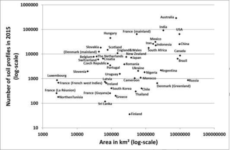
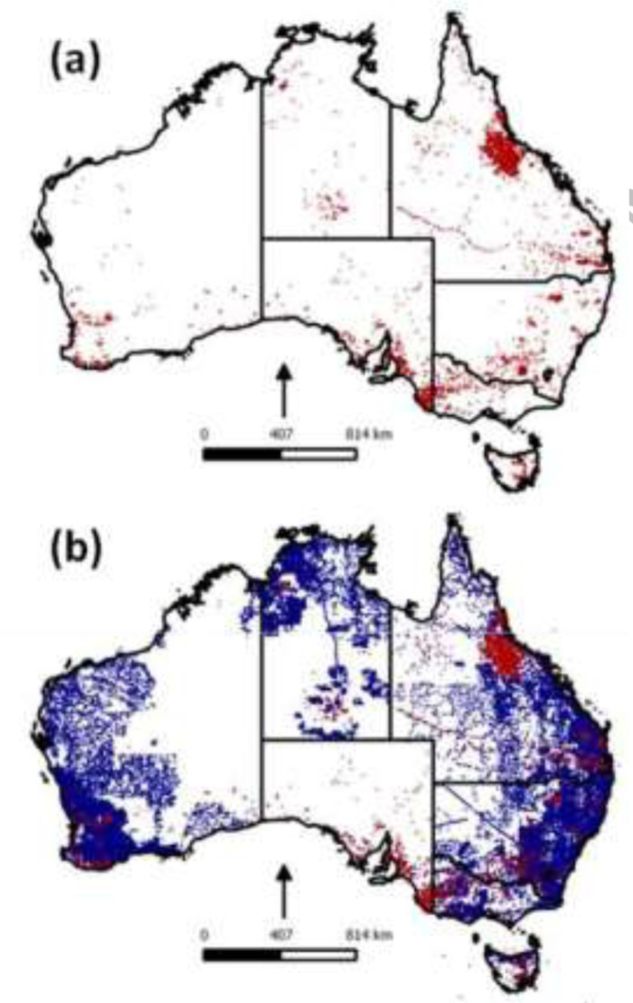
Legacy soil data have been produced over 70 years in nearly all countries of the world. Unfortunately, data, information and knowledge are still currently fragmented and at risk of getting lost if they remain in a paper format. To process this legacy data into consistent, spatially explicit and continuous global soil information, data are being rescued and compiled into databases. Thousands of soil survey reports and maps have been scanned and made available online. The soil profile data reported by these data sources have been captured and compiled into databases. The total number of soil profiles rescued in the selected countries is about 800,000. Currently, data for 117, 000 profiles are compiled and harmonized according to GlobalSoilMap specifications in a world level database (WoSIS). The results presented at the country level are likely to be an underestimate. The majority of soil data is still not rescued and this effort should be pursued. The data have been used to produce soil property maps. We discuss the pro and cons of top-down and bottom-up approaches to produce such maps and we stress their complementarity. We give examples of success stories. The first global soil property maps using rescued data were produced by a top-down approach and were released at a limited resolution of 1km in 2014, followed by an update at a resolution of 250m in 2017. By the end of 2020, we aim to deliver the first worldwide product that fully meets the GlobalSoilMap specifications.

摘要

在世界几乎所有国家,传统土壤数据的产生已有70多年历史。遗憾的是,目前数据、信息和知识仍处于碎片化状态,若仍以纸质形式保存,有丢失风险。为将这些传统数据处理成一致、空间明确且连续的全球土壤信息,数据正被抢救并汇编到数据库中。数千份土壤调查报告和地图已被扫描并在线提供。这些数据源报告的土壤剖面数据已被采集并汇编到数据库中。在选定国家抢救的土壤剖面总数约为80万。目前,根据全球土壤图规范,在一个世界层面数据库(WoSIS)中已汇编并协调了11.7万个剖面的数据。在国家层面呈现的结果可能被低估了。大部分土壤数据仍未被抢救,应继续开展这项工作。这些数据已被用于制作土壤属性图。我们讨论了自上而下和自下而上方法制作此类地图的利弊,并强调了它们的互补性。我们给出了成功案例。利用抢救数据制作的首批全球土壤属性图是通过自上而下的方法制作的,于2014年以1公里的有限分辨率发布,随后在2017年以250米的分辨率进行了更新。到2020年底,我们的目标是提供首个完全符合全球土壤图规范的全球产品。

https://cdn.ncbi.nlm.nih.gov/pmc/blobs/392a/7450209/dcbef7ec3882/CIAT-2017-j-grj-2017-06-001-g008.jpg
https://cdn.ncbi.nlm.nih.gov/pmc/blobs/392a/7450209/c681d2a26bbe/CIAT-2017-j-grj-2017-06-001-g001.jpg
https://cdn.ncbi.nlm.nih.gov/pmc/blobs/392a/7450209/1dda109bc5a8/CIAT-2017-j-grj-2017-06-001-g002.jpg
https://cdn.ncbi.nlm.nih.gov/pmc/blobs/392a/7450209/80bf64dca94a/CIAT-2017-j-grj-2017-06-001-g003.jpg
https://cdn.ncbi.nlm.nih.gov/pmc/blobs/392a/7450209/fa80e23c7698/CIAT-2017-j-grj-2017-06-001-g004.jpg
https://cdn.ncbi.nlm.nih.gov/pmc/blobs/392a/7450209/573d5c1ea97e/CIAT-2017-j-grj-2017-06-001-g005.jpg
https://cdn.ncbi.nlm.nih.gov/pmc/blobs/392a/7450209/466987665162/CIAT-2017-j-grj-2017-06-001-g006.jpg
https://cdn.ncbi.nlm.nih.gov/pmc/blobs/392a/7450209/39bbc8a36afb/CIAT-2017-j-grj-2017-06-001-g007.jpg
https://cdn.ncbi.nlm.nih.gov/pmc/blobs/392a/7450209/dcbef7ec3882/CIAT-2017-j-grj-2017-06-001-g008.jpg

相似文献

1
Soil legacy data rescue via GlobalSoilMap and other international and national initiatives.通过全球土壤地图及其他国际和国家倡议进行土壤遗留数据抢救。
GeoResJ. 2017 Dec;14(9):1-19. doi: 10.1016/j.grj.2017.06.001.
2
Folic acid supplementation and malaria susceptibility and severity among people taking antifolate antimalarial drugs in endemic areas.在流行地区,服用抗叶酸抗疟药物的人群中,叶酸补充剂与疟疾易感性和严重程度的关系。
Cochrane Database Syst Rev. 2022 Feb 1;2(2022):CD014217. doi: 10.1002/14651858.CD014217.
3
The first version of nation-wide open 3D soil database for Sri Lanka.斯里兰卡全国性开放式3D土壤数据库的首个版本。
Data Brief. 2020 Sep 24;33:106342. doi: 10.1016/j.dib.2020.106342. eCollection 2020 Dec.
4
CLSoilMaps: A national soil gridded database of physical and hydraulic soil properties for Chile.CLSoilMaps:智利国家土壤物理和水力性质栅格数据库。
Sci Data. 2023 Sep 16;10(1):630. doi: 10.1038/s41597-023-02536-x.
5
High-resolution three-dimensional mapping of soil organic carbon in China: Effects of SoilGrids products on national modeling.中国土壤有机碳的高分辨率三维制图:SoilGrids产品对全国模型的影响
Sci Total Environ. 2019 Oct 1;685:480-489. doi: 10.1016/j.scitotenv.2019.05.332. Epub 2019 May 28.
6
GlobalSoilMap France: High-resolution spatial modelling the soils of France up to two meter depth.法国全球土壤图:高达两米深度的法国土壤高分辨率空间建模。
Sci Total Environ. 2016 Dec 15;573:1352-1369. doi: 10.1016/j.scitotenv.2016.07.066. Epub 2016 Jul 16.
7
Mapping rootable depth and root zone plant-available water holding capacity of the soil of sub-Saharan Africa.绘制撒哈拉以南非洲土壤的可生根深度和根区植物有效持水量图。
Geoderma. 2018 Aug 15;324:18-36. doi: 10.1016/j.geoderma.2018.02.046.
8
Mapping high resolution National Soil Information Grids of China.绘制中国高分辨率国家土壤信息网格图。
Sci Bull (Beijing). 2022 Feb 15;67(3):328-340. doi: 10.1016/j.scib.2021.10.013. Epub 2021 Oct 22.
9
Updating categorical soil maps using limited survey data by Bayesian Markov chain cosimulation.利用贝叶斯马尔可夫链协同模拟,通过有限的调查数据更新分类土壤图。
ScientificWorldJournal. 2013 Aug 20;2013:587284. doi: 10.1155/2013/587284. eCollection 2013.
10
Disaggregation of legacy soil data using area to point kriging for mapping soil organic carbon at the regional scale.利用面积到点克里金法对遗留土壤数据进行分解,以绘制区域尺度的土壤有机碳图。
Geoderma. 2012 Jan 15;170:347-358. doi: 10.1016/j.geoderma.2011.10.007.

引用本文的文献

1
Machine learning ensemble technique for exploring soil type evolution.用于探索土壤类型演变的机器学习集成技术
Sci Rep. 2025 Jul 7;15(1):24332. doi: 10.1038/s41598-025-10608-8.
2
The GrassSyn dataset: Soil organic carbon stocks in Brazilian grassy ecosystems.GrassSyn数据集:巴西草地生态系统中的土壤有机碳储量。
J Environ Qual. 2025 Mar-Apr;54(2):335-348. doi: 10.1002/jeq2.20665. Epub 2024 Dec 25.
3
Climatic and soil factors explain the two-dimensional spectrum of global plant trait variation.气候和土壤因素解释了全球植物性状变化的二维谱。

本文引用的文献

1
Mapping LUCAS topsoil chemical properties at European scale using Gaussian process regression.利用高斯过程回归在欧洲尺度上绘制卢卡斯表土化学性质图。
Geoderma. 2019 Dec 1;355:113912. doi: 10.1016/j.geoderma.2019.113912.
2
SoilGrids250m: Global gridded soil information based on machine learning.SoilGrids250m:基于机器学习的全球网格化土壤信息。
PLoS One. 2017 Feb 16;12(2):e0169748. doi: 10.1371/journal.pone.0169748. eCollection 2017.
3
GlobalSoilMap France: High-resolution spatial modelling the soils of France up to two meter depth.
Nat Ecol Evol. 2022 Jan;6(1):36-50. doi: 10.1038/s41559-021-01616-8. Epub 2021 Dec 23.
4
African soil properties and nutrients mapped at 30 m spatial resolution using two-scale ensemble machine learning.利用两尺度集成机器学习以 30 米空间分辨率绘制非洲土壤属性和养分图。
Sci Rep. 2021 Mar 17;11(1):6130. doi: 10.1038/s41598-021-85639-y.
5
Mapping LUCAS topsoil chemical properties at European scale using Gaussian process regression.利用高斯过程回归在欧洲尺度上绘制卢卡斯表土化学性质图。
Geoderma. 2019 Dec 1;355:113912. doi: 10.1016/j.geoderma.2019.113912.
6
Soil data for mapping paludification in black spruce forests of eastern Canada.加拿大东部黑云杉林泥炭化制图的土壤数据。
Data Brief. 2018 Nov 29;21:2616-2621. doi: 10.1016/j.dib.2018.11.131. eCollection 2018 Dec.
法国全球土壤图:高达两米深度的法国土壤高分辨率空间建模。
Sci Total Environ. 2016 Dec 15;573:1352-1369. doi: 10.1016/j.scitotenv.2016.07.066. Epub 2016 Jul 16.
4
Mapping Soil Properties of Africa at 250 m Resolution: Random Forests Significantly Improve Current Predictions.以250米分辨率绘制非洲土壤属性图:随机森林显著改进当前预测结果。
PLoS One. 2015 Jun 25;10(6):e0125814. doi: 10.1371/journal.pone.0125814. eCollection 2015.
5
Soil science. Soil and human security in the 21st century.土壤科学。21 世纪的土壤与人类安全。
Science. 2015 May 8;348(6235):1261071. doi: 10.1126/science.1261071. Epub 2015 May 7.
6
Disaggregation of legacy soil data using area to point kriging for mapping soil organic carbon at the regional scale.利用面积到点克里金法对遗留土壤数据进行分解,以绘制区域尺度的土壤有机碳图。
Geoderma. 2012 Jan 15;170:347-358. doi: 10.1016/j.geoderma.2011.10.007.
7
SoilGrids1km--global soil information based on automated mapping.SoilGrids1km——基于自动制图的全球土壤信息。
PLoS One. 2014 Aug 29;9(8):e105992. doi: 10.1371/journal.pone.0105992. eCollection 2014.
8
Digital mapping of soil organic carbon contents and stocks in Denmark.丹麦土壤有机碳含量与储量的数字制图
PLoS One. 2014 Aug 19;9(8):e105519. doi: 10.1371/journal.pone.0105519. eCollection 2014.
9
Baseline map of organic carbon in Australian soil to support national carbon accounting and monitoring under climate change.澳大利亚土壤有机碳基线图,以支持气候变化下的国家碳核算与监测。
Glob Chang Biol. 2014 Sep;20(9):2953-70. doi: 10.1111/gcb.12569. Epub 2014 Apr 28.
10
The LUCAS topsoil database and derived information on the regional variability of cropland topsoil properties in the European Union.欧盟卢卡斯表土层数据库及其衍生的农田表土层属性区域变异性信息。
Environ Monit Assess. 2013 Sep;185(9):7409-25. doi: 10.1007/s10661-013-3109-3. Epub 2013 Feb 1.