• 文献检索
  • 文档翻译
  • 深度研究
  • 学术资讯
  • Suppr Zotero 插件Zotero 插件
  • 邀请有礼
  • 套餐&价格
  • 历史记录
应用&插件
Suppr Zotero 插件Zotero 插件浏览器插件Mac 客户端Windows 客户端微信小程序
定价
高级版会员购买积分包购买API积分包
服务
文献检索文档翻译深度研究API 文档MCP 服务
关于我们
关于 Suppr公司介绍联系我们用户协议隐私条款
关注我们

Suppr 超能文献

核心技术专利:CN118964589B侵权必究
粤ICP备2023148730 号-1Suppr @ 2026

文献检索

告别复杂PubMed语法,用中文像聊天一样搜索,搜遍4000万医学文献。AI智能推荐,让科研检索更轻松。

立即免费搜索

文件翻译

保留排版,准确专业,支持PDF/Word/PPT等文件格式,支持 12+语言互译。

免费翻译文档

深度研究

AI帮你快速写综述,25分钟生成高质量综述,智能提取关键信息,辅助科研写作。

立即免费体验

R/UAStools::plotshpcreate:创建用于提取研究地块尺度农业遥感数据的多多边形 shapefile 文件。

R/UAStools::plotshpcreate: Create Multi-Polygon Shapefiles for Extraction of Research Plot Scale Agriculture Remote Sensing Data.

作者信息

Anderson Steven L, Murray Seth C

机构信息

Department of Soil and Crop Sciences, Texas A&M University, College Station, TX, United States.

出版信息

Front Plant Sci. 2020 Sep 30;11:511768. doi: 10.3389/fpls.2020.511768. eCollection 2020.

DOI:10.3389/fpls.2020.511768
PMID:33101323
原文链接:https://pmc.ncbi.nlm.nih.gov/articles/PMC7554333/
Abstract

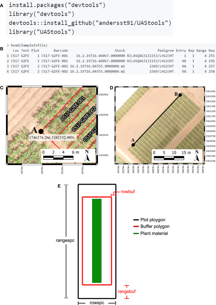
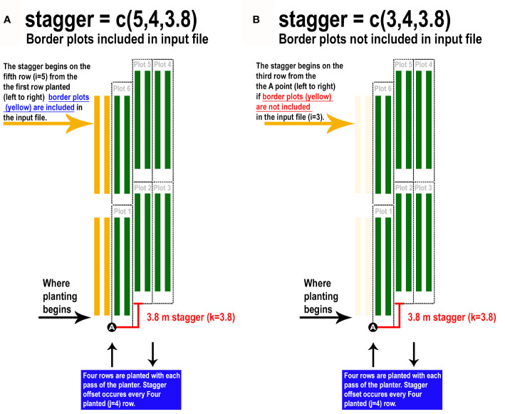
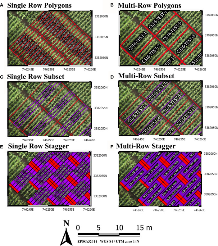
Agricultural researchers are embracing remote sensing tools to phenotype and monitor agriculture crops. Specifically, large quantities of data are now being collected on small plot research studies using Unoccupied Aerial Systems (UAS, aka drones), ground systems, or other technologies but data processing and analysis lags behind. One major contributor to current data processing bottlenecks has been the lack of publicly available software tools tailored towards remote sensing of small plots and usability for researchers inexperienced in remote sensing. To address these needs we created plot shapefile maker (R/UAS::plotshpcreate): an open source R function which rapidly creates ESRI polygon shapefiles to the desired dimensions of individual agriculture research plots areas of interest and associates plot specific information. Plotshpcreate was developed to utilize inputs containing experimental design, field orientation, and plot dimensions for easily creating a multi-polygon shapefile of an entire small plot experiment. Output shapefiles are based on the user inputs geolocation of the research field ensuring accurate overlay of polygons often without manual user adjustment. The output shapefile is useful in GIS software to extract plot level data tracing back to the unique IDs of the experimental plots. Plotshpcreate is available on GitHub (https://github.com/andersst91/UAStools).

摘要

农业研究人员正在采用遥感工具来对农作物进行表型分析和监测。具体而言,目前正在使用无人机系统(UAS,即无人机)、地面系统或其他技术在小地块研究中收集大量数据,但数据处理和分析却滞后了。当前数据处理瓶颈的一个主要原因是缺乏专门针对小地块遥感且便于遥感经验不足的研究人员使用的公开可用软件工具。为满足这些需求,我们创建了地块形状文件制作工具(R/UAS::plotshpcreate):一个开源R函数,它能快速创建ESRI多边形形状文件,使其达到各个农业研究地块感兴趣区域的所需尺寸,并关联地块特定信息。开发plotshpcreate是为了利用包含实验设计、田间方位和地块尺寸的输入,以便轻松创建整个小地块实验的多多边形形状文件。输出的形状文件基于用户输入的研究田地理位置,确保多边形的准确叠加,通常无需用户手动调整。输出的形状文件在GIS软件中很有用,可用于提取可追溯到实验地块唯一ID的地块级数据。Plotshpcreate可在GitHub上获取(https://github.com/andersst91/UAStools)。

https://cdn.ncbi.nlm.nih.gov/pmc/blobs/f2a7/7554333/0fc987ec64cd/fpls-11-511768-g003.jpg
https://cdn.ncbi.nlm.nih.gov/pmc/blobs/f2a7/7554333/0a048d53cdde/fpls-11-511768-g001.jpg
https://cdn.ncbi.nlm.nih.gov/pmc/blobs/f2a7/7554333/e26ad96f571a/fpls-11-511768-g002.jpg
https://cdn.ncbi.nlm.nih.gov/pmc/blobs/f2a7/7554333/0fc987ec64cd/fpls-11-511768-g003.jpg
https://cdn.ncbi.nlm.nih.gov/pmc/blobs/f2a7/7554333/0a048d53cdde/fpls-11-511768-g001.jpg
https://cdn.ncbi.nlm.nih.gov/pmc/blobs/f2a7/7554333/e26ad96f571a/fpls-11-511768-g002.jpg
https://cdn.ncbi.nlm.nih.gov/pmc/blobs/f2a7/7554333/0fc987ec64cd/fpls-11-511768-g003.jpg

相似文献

1
R/UAStools::plotshpcreate: Create Multi-Polygon Shapefiles for Extraction of Research Plot Scale Agriculture Remote Sensing Data.R/UAStools::plotshpcreate:创建用于提取研究地块尺度农业遥感数据的多多边形 shapefile 文件。
Front Plant Sci. 2020 Sep 30;11:511768. doi: 10.3389/fpls.2020.511768. eCollection 2020.
2
A method for creating complex real-world networks using ESRI Shapefiles.一种使用ESRI Shapefiles创建复杂现实世界网络的方法。
MethodsX. 2023 Oct 11;11:102426. doi: 10.1016/j.mex.2023.102426. eCollection 2023 Dec.
3
Semi-Automated Field Plot Segmentation From UAS Imagery for Experimental Agriculture.基于无人机图像的实验农业半自动田间地块分割
Front Plant Sci. 2020 Dec 9;11:591886. doi: 10.3389/fpls.2020.591886. eCollection 2020.
4
An Automatic Field Plot Extraction Method From Aerial Orthomosaic Images.一种从航空正射影像中自动提取地块的方法
Front Plant Sci. 2019 May 29;10:683. doi: 10.3389/fpls.2019.00683. eCollection 2019.
5
[Comparison of precision in retrieving soybean leaf area index based on multi-source remote sensing data].基于多源遥感数据反演大豆叶面积指数的精度比较
Ying Yong Sheng Tai Xue Bao. 2016 Jan;27(1):191-200.
6
Introducing : Fast user-friendly software for machine- and human-readable labels in agricultural research and development.介绍:适用于农业研发领域的机器可读和人工可读标签的快速用户友好型软件。
Gates Open Res. 2024 Mar 27;8:28. doi: 10.12688/gatesopenres.15268.1. eCollection 2024.
7
Row selection in remote sensing from four-row plots of maize and sorghum based on repeatability and predictive modeling.基于重复性和预测模型,从玉米和高粱的四行小区进行遥感行选择。
Front Plant Sci. 2023 Jun 20;14:1202536. doi: 10.3389/fpls.2023.1202536. eCollection 2023.
8
Using open-source software and digital imagery to efficiently and objectively quantify cover density of an invasive alien plant species.利用开源软件和数字图像,高效、客观地量化入侵外来植物物种的盖度。
J Environ Manage. 2020 Jul 15;266:110519. doi: 10.1016/j.jenvman.2020.110519. Epub 2020 Apr 29.
9
shinyCircos: an R/Shiny application for interactive creation of Circos plot.shinyCircos:一个用于交互式创建 Circos 图的 R/Shiny 应用程序。
Bioinformatics. 2018 Apr 1;34(7):1229-1231. doi: 10.1093/bioinformatics/btx763.
10
Assessment and statistical modeling of the relationship between remotely sensed aerosol optical depth and PM2.5 in the eastern United States.美国东部地区遥感气溶胶光学厚度与PM2.5之间关系的评估及统计建模
Res Rep Health Eff Inst. 2012 May(167):5-83; discussion 85-91.

引用本文的文献

1
IHUP: An Integrated High-Throughput Universal Phenotyping Software Platform to Accelerate Unmanned-Aerial-Vehicle-Based Field Plant Phenotypic Data Extraction and Analysis.IHUP:一个集成的高通量通用表型分析软件平台,用于加速基于无人机的田间植物表型数据提取与分析。
Plant Phenomics. 2024 May 15;6:0164. doi: 10.34133/plantphenomics.0164. eCollection 2024.
2
Field-based high-throughput phenotyping enhances phenomic and genomic predictions for grain yield and plant height across years in maize.基于田间的高通量表型分析提高了玉米多年来的表型和基因组对籽粒产量和株高的预测能力。
G3 (Bethesda). 2024 Jul 8;14(7). doi: 10.1093/g3journal/jkae092.
3

本文引用的文献

1
Translating High-Throughput Phenotyping into Genetic Gain.高通量表型分析转化为遗传增益。
Trends Plant Sci. 2018 May;23(5):451-466. doi: 10.1016/j.tplants.2018.02.001. Epub 2018 Mar 16.
2
High throughput phenotyping to accelerate crop breeding and monitoring of diseases in the field.高通量表型分析以加速作物育种和田间病害监测。
Curr Opin Plant Biol. 2017 Aug;38:184-192. doi: 10.1016/j.pbi.2017.05.006. Epub 2017 Jul 21.
Temporal phenomic predictions from unoccupied aerial systems can outperform genomic predictions.
无人航空系统的时间表型预测可以优于基因组预测。
G3 (Bethesda). 2023 Jan 12;13(1). doi: 10.1093/g3journal/jkac294.
4
AirMeasurer: open-source software to quantify static and dynamic traits derived from multiseason aerial phenotyping to empower genetic mapping studies in rice.AirMeasurer:开源软件,可用于量化多季节航空表型衍生的静态和动态特征,为水稻遗传图谱研究提供支持。
New Phytol. 2022 Nov;236(4):1584-1604. doi: 10.1111/nph.18314. Epub 2022 Jul 28.
5
Phenomic data-facilitated rust and senescence prediction in maize using machine learning algorithms.利用机器学习算法进行表型数据分析,预测玉米锈病和衰老。
Sci Rep. 2022 May 9;12(1):7571. doi: 10.1038/s41598-022-11591-0.