Department of Remote Sensing and GIS, University of Tabriz, Tabriz 5166616471, Iran.
Institute of Environment, University of Tabriz, Tabriz 5166616471, Iran.
Sensors (Basel). 2020 Dec 3;20(23):6913. doi: 10.3390/s20236913.
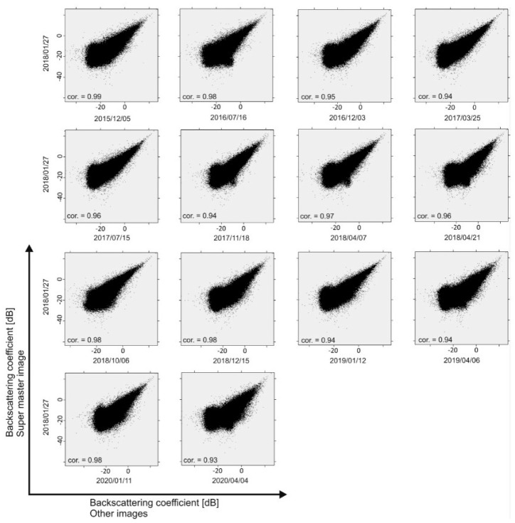
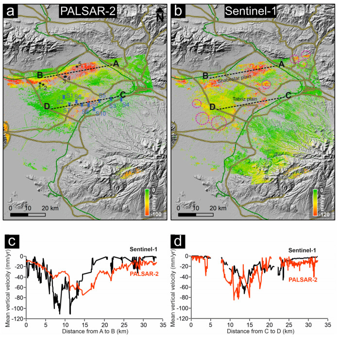
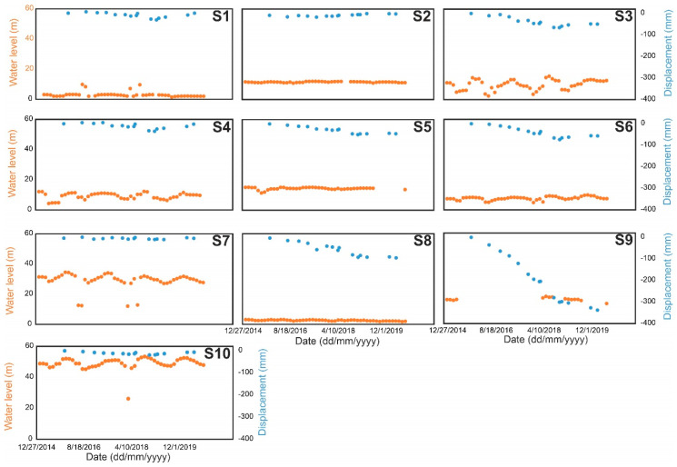
Iran, as a semi-arid and arid country, has a water challenge in the recent decades and underground water extraction has been increased because of improper developments in the agricultural sector. Thus, detection and measurement of ground subsidence in major plains is of great importance for hazard mitigation purposes. In this study, we carried out a time series small baseline subset (SBAS) interferometric synthetic aperture radar (InSAR) analysis of 15 L-band PALSAR-2 images acquired from ascending orbits of the ALOS-2 satellite between 2015 and 2020 to investigate long-term ground displacements in East Azerbaijan Province, Iran. We found that two major parts of the study area (Tabriz and Shabestar plains) are subsiding, where the mean and maximum vertical subsidence rates are -10 and -98 mm/year, respectively. The results revealed that the visible subsidence patterns in the study area are associated with either anthropogenic activities (e.g., underground water usage) or presence of compressible soils along the Tabriz-Shabestar and Tabriz-Azarshahr railways. This implies that infrastructure such as railways and roads is vulnerable if progressive ground subsidence takes over the whole area. The SBAS results deduced from L-band PALSAR-2 data were validated with field observations and compared with C-band Sentinel-1 results for the same period. The C-band Sentinel-1 results showed good agreement with the L-band PALSAR-2 dataset, in which the mean and maximum vertical subsidence rates are -13 and -120 mm/year, respectively. For better visualization of the results, the SBAS InSAR velocity map was down-sampled and principal component analysis (PCA) was performed on ~3600 randomly selected time series of the study area, and the results are presented by two principal components (PC1 and PC2).
伊朗是一个半干旱和干旱国家,在最近几十年面临着水资源挑战,由于农业部门的不当发展,地下水资源的开采量有所增加。因此,探测和测量主要平原的地面沉降对于减轻灾害具有重要意义。在这项研究中,我们对 2015 年至 2020 年间,日本 ALOS-2 卫星从升轨获取的 15 景 L 波段 PALSAR-2 影像进行了小基线子集(SBAS)干涉合成孔径雷达(InSAR)时间序列分析,以研究伊朗东阿塞拜疆省的长期地面位移。我们发现,研究区的两个主要部分(大不里士和平原和沙赫巴斯特平原)正在沉降,平均和最大垂直沉降速率分别为-10 和-98 毫米/年。结果表明,研究区可见的沉降模式与地下水资源的使用或沿大不里士-沙赫巴斯特和大不里士-阿扎尔沙赫尔铁路存在可压缩土壤有关。这意味着,如果整个地区发生渐进性地面沉降,那么铁路和道路等基础设施将很脆弱。基于 L 波段 PALSAR-2 数据的 SBAS 结果与现场观测结果进行了验证,并与同期 C 波段 Sentinel-1 结果进行了比较。C 波段 Sentinel-1 结果与 L 波段 PALSAR-2 数据集具有很好的一致性,平均和最大垂直沉降速率分别为-13 和-120 毫米/年。为了更好地可视化结果,对 SBAS InSAR 速度图进行了下采样,并对研究区约 3600 个随机选择的时间序列进行了主成分分析(PCA),结果由两个主成分(PC1 和 PC2)表示。