• 文献检索
  • 文档翻译
  • 深度研究
  • 学术资讯
  • Suppr Zotero 插件Zotero 插件
  • 邀请有礼
  • 套餐&价格
  • 历史记录
应用&插件
Suppr Zotero 插件Zotero 插件浏览器插件Mac 客户端Windows 客户端微信小程序
定价
高级版会员购买积分包购买API积分包
服务
文献检索文档翻译深度研究API 文档MCP 服务
关于我们
关于 Suppr公司介绍联系我们用户协议隐私条款
关注我们

Suppr 超能文献

核心技术专利:CN118964589B侵权必究
粤ICP备2023148730 号-1Suppr @ 2026

文献检索

告别复杂PubMed语法,用中文像聊天一样搜索,搜遍4000万医学文献。AI智能推荐,让科研检索更轻松。

立即免费搜索

文件翻译

保留排版,准确专业,支持PDF/Word/PPT等文件格式,支持 12+语言互译。

免费翻译文档

深度研究

AI帮你快速写综述,25分钟生成高质量综述,智能提取关键信息,辅助科研写作。

立即免费体验

全国道路质量图的开发:遥感与现场感测相结合。

Development of Nationwide Road Quality Map: Remote Sensing Meets Field Sensing.

机构信息

Department of Remote Sensing and GIS, University of Tabriz, Tabriz 5166616471, Iran.

Institute of Environment, University of Tabriz, Tabriz 5166616471, Iran.

出版信息

Sensors (Basel). 2021 Mar 23;21(6):2251. doi: 10.3390/s21062251.

DOI:10.3390/s21062251
PMID:33807090
原文链接:https://pmc.ncbi.nlm.nih.gov/articles/PMC8004802/
Abstract

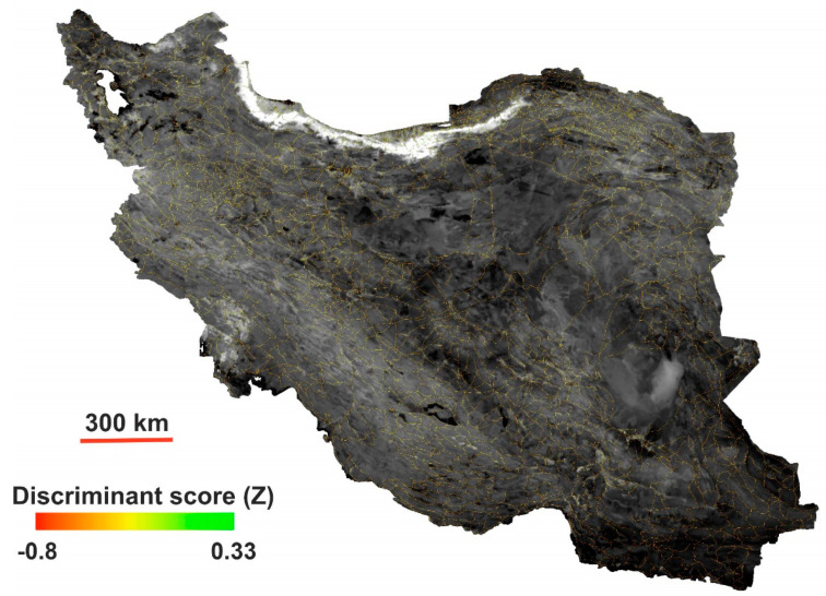
In this study, we measured the in situ international roughness index (IRI) for first-degree roads spanning more than 1300 km in East Azerbaijan Province, Iran, using a quarter car (QC). Since road quality mapping with in situ measurements is a costly and time-consuming task, we also developed new equations for constructing a road quality proxy map (RQPM) using discriminant analysis and multispectral information from high-resolution Sentinel-2 images, which we calibrated using the in situ data on the basis of geographic information system (GIS) data. The developed equations using optimum index factor (OIF) and norm R provide a valuable tool for creating proxy maps and mitigating hazards at the network scale, not only for primary roads but also for secondary roads, and for reducing the costs of road quality monitoring. The overall accuracy and kappa coefficient of the norm R equation for road classification in East Azerbaijan province are 65.0% and 0.59, respectively.

摘要

在这项研究中,我们使用四分之一车(QC)测量了伊朗东阿塞拜疆省超过 1300 公里的一级道路的原地国际粗糙度指数(IRI)。由于使用原地测量进行道路质量测绘是一项昂贵且耗时的任务,我们还开发了新的方程,使用判别分析和高分辨率 Sentinel-2 图像的多光谱信息构建道路质量代理图(RQPM),我们使用基于地理信息系统(GIS)数据的原地数据对其进行校准。使用最优指数因子(OIF)和规范 R 开发的方程为创建代理图和缓解网络规模的危险提供了有价值的工具,不仅适用于主要道路,也适用于次要道路,并降低了道路质量监测的成本。规范 R 方程在东阿塞拜疆省进行道路分类的总准确性和kappa 系数分别为 65.0%和 0.59。

https://cdn.ncbi.nlm.nih.gov/pmc/blobs/ed6f/8004802/2bde0efff47d/sensors-21-02251-g008.jpg
https://cdn.ncbi.nlm.nih.gov/pmc/blobs/ed6f/8004802/cee0040de33b/sensors-21-02251-g001.jpg
https://cdn.ncbi.nlm.nih.gov/pmc/blobs/ed6f/8004802/e2638bc16b0c/sensors-21-02251-g002.jpg
https://cdn.ncbi.nlm.nih.gov/pmc/blobs/ed6f/8004802/82b8dde9f7e8/sensors-21-02251-g003.jpg
https://cdn.ncbi.nlm.nih.gov/pmc/blobs/ed6f/8004802/41b9116df5f5/sensors-21-02251-g004.jpg
https://cdn.ncbi.nlm.nih.gov/pmc/blobs/ed6f/8004802/2d79887ee2fe/sensors-21-02251-g005.jpg
https://cdn.ncbi.nlm.nih.gov/pmc/blobs/ed6f/8004802/7380aaf87429/sensors-21-02251-g006.jpg
https://cdn.ncbi.nlm.nih.gov/pmc/blobs/ed6f/8004802/2254aa30ab14/sensors-21-02251-g007.jpg
https://cdn.ncbi.nlm.nih.gov/pmc/blobs/ed6f/8004802/2bde0efff47d/sensors-21-02251-g008.jpg

相似文献

1
Development of Nationwide Road Quality Map: Remote Sensing Meets Field Sensing.全国道路质量图的开发:遥感与现场感测相结合。
Sensors (Basel). 2021 Mar 23;21(6):2251. doi: 10.3390/s21062251.
2
Road Extraction from High Resolution Remote Sensing Images Based on Vector Field Learning.基于矢量场学习的高分辨率遥感图像道路提取。
Sensors (Basel). 2021 May 1;21(9):3152. doi: 10.3390/s21093152.
3
A Survey of Deep Learning Road Extraction Algorithms Using High-Resolution Remote Sensing Images.基于高分辨率遥感影像的深度学习道路提取算法综述
Sensors (Basel). 2024 Mar 6;24(5):1708. doi: 10.3390/s24051708.
4
Assessment and statistical modeling of the relationship between remotely sensed aerosol optical depth and PM2.5 in the eastern United States.美国东部地区遥感气溶胶光学厚度与PM2.5之间关系的评估及统计建模
Res Rep Health Eff Inst. 2012 May(167):5-83; discussion 85-91.
5
Development of a GIS-Based Methodology for the Management of Stone Pavements Using Low-Cost Sensors.基于 GIS 的低成本传感器在石质铺地管理中的应用方法开发。
Sensors (Basel). 2022 Aug 31;22(17):6560. doi: 10.3390/s22176560.
6
Using remote sensing data to predict road fill areas and areas affected by fill erosion with planned forest road construction: a case study in Kastamonu Regional Forest Directorate (Turkey).利用遥感数据预测规划中的森林道路建设所涉及的道路填方区域及受填方侵蚀影响的区域:以土耳其卡斯塔莫努地区林业局为例
Environ Monit Assess. 2015 Jul;187(7):417. doi: 10.1007/s10661-015-4663-7. Epub 2015 Jun 9.
7
Assessing and Mapping of Road Surface Roughness based on GPS and Accelerometer Sensors on Bicycle-Mounted Smartphones.基于自行车搭载智能手机上的全球定位系统(GPS)和加速度计传感器的路面粗糙度评估与测绘
Sensors (Basel). 2018 Mar 19;18(3):914. doi: 10.3390/s18030914.
8
Using GIS-based multicriteria decision support system for planning road networks with visual quality constraints: a case study of protected areas in Ankara, Turkey.基于 GIS 的多准则决策支持系统在具有视觉质量约束的道路网络规划中的应用:以土耳其安卡拉保护区为例。
Environ Monit Assess. 2020 Jun 22;192(7):447. doi: 10.1007/s10661-020-08417-9.
9
A GIS-MCDM-based road network planning for tourism development and management in Arasbaran forest, Iran.基于 GIS-MCDM 的伊朗阿拉斯拜兰森林旅游发展与管理道路网络规划
Environ Monit Assess. 2019 Oct 16;191(11):647. doi: 10.1007/s10661-019-7831-3.
10
Road Extraction from Unmanned Aerial Vehicle Remote Sensing Images Based on Improved Neural Networks.基于改进神经网络的无人机遥感图像道路提取。
Sensors (Basel). 2019 Sep 23;19(19):4115. doi: 10.3390/s19194115.

本文引用的文献

1
Extraction of Land Information, Future Landscape Changes and Seismic Hazard Assessment: A Case Study of Tabriz, Iran.土地信息提取、未来景观变化和地震灾害评估:以伊朗大不里士为例。
Sensors (Basel). 2020 Dec 8;20(24):7010. doi: 10.3390/s20247010.
2
Ground Displacement in East Azerbaijan Province, Iran, Revealed by L-band and C-band InSAR Analyses.伊朗东阿塞拜疆省的地面位移通过 L 波段和 C 波段 InSAR 分析揭示。
Sensors (Basel). 2020 Dec 3;20(23):6913. doi: 10.3390/s20236913.
3
Remote Sensing X-Band SAR Data for Land Subsidence and Pavement Monitoring.
用于地面沉降和路面监测的遥感X波段合成孔径雷达数据
Sensors (Basel). 2020 Aug 22;20(17):4751. doi: 10.3390/s20174751.
4
Spatiotemporal deformation patterns of the Lake Urmia Causeway as characterized by multisensor InSAR analysis.多源 InSAR 分析刻画的乌鲁米耶湖堤道的时空变形模式。
Sci Rep. 2018 Apr 3;8(1):5357. doi: 10.1038/s41598-018-23650-6.
5
Space geodetic monitoring of engineered structures: The ongoing destabilization of the Mosul dam, Iraq.空间大地测量监测工程结构:伊拉克摩苏尔大坝的持续失稳。
Sci Rep. 2016 Dec 6;6:37408. doi: 10.1038/srep37408.