• 文献检索
  • 文档翻译
  • 深度研究
  • 学术资讯
  • Suppr Zotero 插件Zotero 插件
  • 邀请有礼
  • 套餐&价格
  • 历史记录
应用&插件
Suppr Zotero 插件Zotero 插件浏览器插件Mac 客户端Windows 客户端微信小程序
定价
高级版会员购买积分包购买API积分包
服务
文献检索文档翻译深度研究API 文档MCP 服务
关于我们
关于 Suppr公司介绍联系我们用户协议隐私条款
关注我们

Suppr 超能文献

核心技术专利:CN118964589B侵权必究
粤ICP备2023148730 号-1Suppr @ 2026

文献检索

告别复杂PubMed语法,用中文像聊天一样搜索,搜遍4000万医学文献。AI智能推荐,让科研检索更轻松。

立即免费搜索

文件翻译

保留排版,准确专业,支持PDF/Word/PPT等文件格式,支持 12+语言互译。

免费翻译文档

深度研究

AI帮你快速写综述,25分钟生成高质量综述,智能提取关键信息,辅助科研写作。

立即免费体验

中国黑龙江鸡西矿区地表温度的遥感反演与空间变异

Remote sensing inversion and spatial variation of land surface temperature over mining areas of Jixi, Heilongjiang, China.

作者信息

Cao Jia-Shuo, Deng Zheng-Yu, Li Wen, Hu Yuan-Dong

机构信息

College of Landscape Architecture, Northeast Forestry University, Harbin, Heilongjiang, China.

Key Laboratory for Garden Plant Germplasm Development & Landscape Eco-Restoration in Cold Regions of Heilongjiang Province, Harbin, Heilongjiang, China.

出版信息

PeerJ. 2020 Nov 25;8:e10257. doi: 10.7717/peerj.10257. eCollection 2020.

DOI:10.7717/peerj.10257
PMID:33304647
原文链接:https://pmc.ncbi.nlm.nih.gov/articles/PMC7698694/
Abstract

BACKGROUND

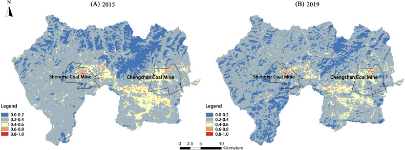
Jixi is a typical mining city in China that has undergone dramatic changes in its land-use pattern of mining areas over the development of its coal resources. The impacts of coal mining activities have greatly affected the regional land surface temperature and ecological system.

METHODS

The Landsat 8 Operational Land Imager (OLI) data from 2015 and 2019 were used from the Jiguan, Didao, and Chengzihe District of Jixi in Heilongjiang, China as the study area. The calculations to determine the land-use classification, vegetation coverage, and land surface temperature (LST) were performed using ArcGIS10.5 and ENVI 5.3 software packages. A correlation analysis revealed the impact of land-use type, vegetation coverage, and coal mining activities on LSTs.

RESULTS

The results show significant spatial differentiation in the LSTs of Jixi City. The LSTs for various land-use types were ranked from high to low as follows: mining land > construction land > grassland > cultivated land > forest land > water area. The LST was lower in areas with high vegetation coverage than in other areas. For every 0.1 increase in vegetation coverage, the LST is expected to drop by approximately 0.75 °C. An analysis of mining land patches indicates that the patch area of mining lands has a significant positive correlation with both the average and maximum patch temperatures. The average patch temperature shows a logarithmic increase with the growth of the patch area, and within 200,000 m, the average patch temperature increases significantly. The maximum patch temperature shows a linear increase with the patch area growth, and for every 100,000 m increase in the patch area of mining lands, the maximum patch temperature increases by approximately 0.81 °C. The higher the average patch temperature of mining land, the higher the temperature in its buffer zone, and the greater its influence scope. This study provides a useful reference for exploring the warming effects caused by coal mining activities and the definition of its influence scope.

摘要

背景

鸡西是中国典型的矿业城市,随着煤炭资源的开发,矿区土地利用格局发生了巨大变化。煤炭开采活动的影响极大地改变了区域地表温度和生态系统。

方法

以中国黑龙江鸡西市鸡冠区、滴道区和城子河区为研究区域,使用2015年和2019年的陆地卫星8号业务陆地成像仪(OLI)数据。利用ArcGIS10.5和ENVI 5.3软件包进行土地利用分类、植被覆盖度和地表温度(LST)的计算。相关性分析揭示了土地利用类型、植被覆盖度和煤炭开采活动对地表温度的影响。

结果

结果表明,鸡西市地表温度存在显著的空间差异。不同土地利用类型的地表温度由高到低排序如下:采矿用地>建设用地>草地>耕地>林地>水域。植被覆盖度高的地区地表温度低于其他地区。植被覆盖度每增加0.1,地表温度预计下降约0.75℃。对采矿用地斑块的分析表明,采矿用地的斑块面积与斑块平均温度和最高温度均呈显著正相关。斑块平均温度随斑块面积的增加呈对数增长,在200000平方米范围内,斑块平均温度显著升高。斑块最高温度随斑块面积的增加呈线性增长,采矿用地斑块面积每增加100000平方米,斑块最高温度升高约0.81℃。采矿用地斑块平均温度越高,其缓冲区温度越高,影响范围越大。本研究为探讨煤炭开采活动引起的升温效应及其影响范围的界定提供了有益参考。

https://cdn.ncbi.nlm.nih.gov/pmc/blobs/58cd/7698694/153c6ff544e1/peerj-08-10257-g011.jpg
https://cdn.ncbi.nlm.nih.gov/pmc/blobs/58cd/7698694/7bf1d48177a4/peerj-08-10257-g001.jpg
https://cdn.ncbi.nlm.nih.gov/pmc/blobs/58cd/7698694/e7a0f42ccf71/peerj-08-10257-g002.jpg
https://cdn.ncbi.nlm.nih.gov/pmc/blobs/58cd/7698694/9b1450025f82/peerj-08-10257-g003.jpg
https://cdn.ncbi.nlm.nih.gov/pmc/blobs/58cd/7698694/e7891cee132c/peerj-08-10257-g004.jpg
https://cdn.ncbi.nlm.nih.gov/pmc/blobs/58cd/7698694/86ee69e46f31/peerj-08-10257-g005.jpg
https://cdn.ncbi.nlm.nih.gov/pmc/blobs/58cd/7698694/8432e75d423c/peerj-08-10257-g006.jpg
https://cdn.ncbi.nlm.nih.gov/pmc/blobs/58cd/7698694/5466da72ec94/peerj-08-10257-g007.jpg
https://cdn.ncbi.nlm.nih.gov/pmc/blobs/58cd/7698694/8a1d04ac638f/peerj-08-10257-g008.jpg
https://cdn.ncbi.nlm.nih.gov/pmc/blobs/58cd/7698694/d4a01e5948bc/peerj-08-10257-g009.jpg
https://cdn.ncbi.nlm.nih.gov/pmc/blobs/58cd/7698694/47271916bd46/peerj-08-10257-g010.jpg
https://cdn.ncbi.nlm.nih.gov/pmc/blobs/58cd/7698694/153c6ff544e1/peerj-08-10257-g011.jpg

相似文献

1
Remote sensing inversion and spatial variation of land surface temperature over mining areas of Jixi, Heilongjiang, China.中国黑龙江鸡西矿区地表温度的遥感反演与空间变异
PeerJ. 2020 Nov 25;8:e10257. doi: 10.7717/peerj.10257. eCollection 2020.
2
Does Coal Mining Have Effects on Land Use Changes in a Coal Resource-Based City? Evidence from Huaibei City on the North China Plain.采煤活动对煤炭资源型城市土地利用变化有影响吗?来自华北平原淮北市的证据。
Int J Environ Res Public Health. 2021 Nov 4;18(21):11616. doi: 10.3390/ijerph182111616.
3
Impact assessment of urban development patterns on land surface temperature by using remote sensing techniques: a case study of Lahore, Faisalabad and Multan district.利用遥感技术评估城市发展模式对地表温度的影响:以拉合尔、费萨拉巴德和木尔坦地区为例。
Environ Sci Pollut Res Int. 2020 Nov;27(32):39865-39878. doi: 10.1007/s11356-020-10050-5. Epub 2020 Aug 4.
4
Ecological disturbance effects of surface vegetation during coal mining in arid regions of Western China.中国西部干旱地区煤炭开采过程中地表植被的生态干扰效应
Environ Monit Assess. 2024 May 2;196(6):498. doi: 10.1007/s10661-024-12664-5.
5
Using POI and time series Landsat data to identify and rebuilt surface mining, vegetation disturbance and land reclamation process based on Google Earth Engine.利用兴趣点(POI)和陆地卫星时间序列数据,基于谷歌地球引擎识别和重建露天采矿、植被干扰及土地复垦过程。
J Environ Manage. 2023 Feb 1;327:116920. doi: 10.1016/j.jenvman.2022.116920. Epub 2022 Dec 1.
6
Land Use Change and Climate Variation in the Three Gorges Reservoir Catchment from 2000 to 2015 Based on the Google Earth Engine.基于谷歌地球引擎的2000年至2015年三峡水库集水区土地利用变化与气候变化
Sensors (Basel). 2019 May 7;19(9):2118. doi: 10.3390/s19092118.
7
Quantifying and simulating landscape composition and pattern impacts on land surface temperature: A decadal study of the rapidly urbanizing city of Beijing, China.量化和模拟景观组成和格局对地表温度的影响:以中国快速城市化的北京市为例的十年研究。
Sci Total Environ. 2019 Mar 1;654:430-440. doi: 10.1016/j.scitotenv.2018.11.108. Epub 2018 Nov 10.
8
Spatial Scale Effects of the Relationship between Fractional Vegetation Coverage and Land Surface Temperature in Horqin Sandy Land, North China.中国北方科尔沁沙地植被覆盖度与地表温度关系的空间尺度效应
Sensors (Basel). 2021 Oct 19;21(20):6914. doi: 10.3390/s21206914.
9
Spatial and Temporal Variation of Land Surface Temperature and Its Spatially Heterogeneous Response in the Urban Agglomeration on the Northern Slopes of the Tianshan Mountains, Northwest China.中国天山北坡城市群陆面温度时空变化及其空间异质性响应
Int J Environ Res Public Health. 2022 Oct 11;19(20):13067. doi: 10.3390/ijerph192013067.
10
Assessment of the environmental changes in arid and semiarid mining areas using long time-series Landsat images.利用多时相 Landsat 图像评估干旱半干旱矿区的环境变化。
Environ Sci Pollut Res Int. 2021 Oct;28(37):52147-52156. doi: 10.1007/s11356-021-14417-0. Epub 2021 May 17.

引用本文的文献

1
Characteristics of the Thermal Environment and its Guidance to Ecological Restoration in a Resource-Based Area in the Loess Area.黄土区资源型城市热环境特征及其对生态恢复的指导意义。
Int J Environ Res Public Health. 2023 Feb 18;20(4):3650. doi: 10.3390/ijerph20043650.
2
Estimation of plant height and yield based on UAV imagery in faba bean (Vicia faba L.).基于无人机图像估算蚕豆(Vicia faba L.)的株高和产量。
Plant Methods. 2022 Mar 5;18(1):26. doi: 10.1186/s13007-022-00861-7.
3
Examining long-term natural vegetation dynamics in the Aral Sea Basin applying the linear spectral mixture model.

本文引用的文献

1
Effects of landscape composition and pattern on land surface temperature: An urban heat island study in the megacities of Southeast Asia.景观组成和格局对地表温度的影响:东南亚特大城市热岛研究。
Sci Total Environ. 2017 Jan 15;577:349-359. doi: 10.1016/j.scitotenv.2016.10.195. Epub 2016 Nov 7.
2
Derivation of land surface temperature for Landsat-8 TIRS using a split window algorithm.利用分裂窗算法推导陆地卫星8号热红外传感器的地表温度
Sensors (Basel). 2014 Mar 25;14(4):5768-80. doi: 10.3390/s140405768.
3
[Correlative analysis of the diversity patterns of regional surface water, NDVI and thermal environment].
应用线性光谱混合模型研究咸海流域的长期自然植被动态。
PeerJ. 2021 Mar 2;9:e10747. doi: 10.7717/peerj.10747. eCollection 2021.
[区域地表水、归一化植被指数与热环境多样性格局的相关性分析]
Ying Yong Sheng Tai Xue Bao. 2012 Oct;23(10):2812-20.
4
Evolution of natural and social science interactions in global change research programs.全球变化研究计划中自然科学和社会科学相互作用的演变。
Proc Natl Acad Sci U S A. 2013 Feb 26;110 Suppl 1(Suppl 1):3665-72. doi: 10.1073/pnas.1107484110. Epub 2013 Jan 7.
5
[Change characteristics and their causes of fractional vegetation coverage (FVC) in Shaanxi Province].[陕西省植被覆盖度(FVC)变化特征及其成因]
Ying Yong Sheng Tai Xue Bao. 2010 Nov;21(11):2896-903.