MARE - Marine and Environmental Sciences Centre, ARDITI - Agência Regional para o Desenvolvimento da Investigação, Tecnologia e Inovação, Funchal, Madeira, Portugal.
Department of Biology and Ecology, Faculty of Science, University of Ostrava, Ostrava, Czech Republic.
Sci Rep. 2021 Jan 12;11(1):574. doi: 10.1038/s41598-020-80612-7.
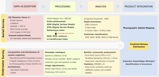
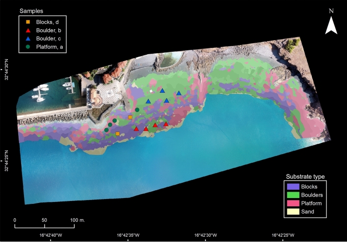
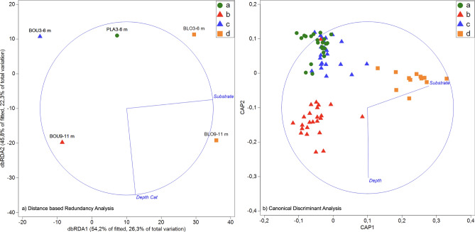
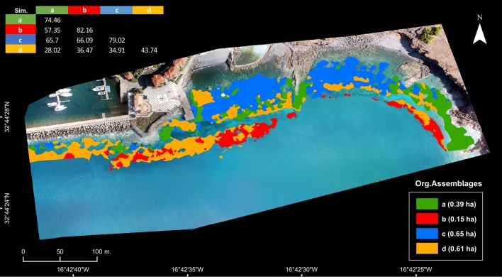
Understanding the complex factors and mechanisms driving the functioning of coastal ecosystems is vital towards assessing how organisms, ecosystems, and ultimately human populations will cope with the ecological consequences of natural and anthropogenic impacts. Towards this goal, coastal monitoring programs and studies must deliver information on a range of variables and factors, from taxonomic/functional diversity and spatial distribution of habitats, to anthropogenic stress indicators such as land use, fisheries use, and pollution. Effective monitoring programs must therefore integrate observations from different sources and spatial scales to provide a comprehensive view to managers. Here we explore integrating aerial surveys from a low-cost Remotely Piloted Aircraft System (RPAS) with concurrent underwater surveys to deliver a novel approach to coastal monitoring. We: (i) map depth and substrate of shallow rocky habitats, and; (ii) classify the major biotopes associated with these environmental axes; and (iii) combine data from i and ii to assess the likely distribution of common sessile organismal assemblages over the survey area. Finally, we propose a general workflow that can be adapted to different needs and aerial platforms, which can be used as blueprints for further integration of remote-sensing with in situ surveys to produce spatially-explicit biotope maps.
了解驱动沿海生态系统功能的复杂因素和机制对于评估生物、生态系统以及最终人类种群将如何应对自然和人为影响的生态后果至关重要。为此,沿海监测计划和研究必须提供有关一系列变量和因素的信息,从分类/功能多样性和栖息地的空间分布,到土地利用、渔业利用和污染等人为压力指标。有效的监测计划因此必须整合来自不同来源和空间尺度的观测结果,为管理者提供全面的视图。在这里,我们探索将低成本的遥控飞机系统 (RPAS) 的空中调查与同时进行的水下调查相结合,以提供一种新的沿海监测方法。我们:(i) 绘制浅岩质生境的深度和基质图;(ii) 对与这些环境轴相关的主要生物群落进行分类;(iii) 结合 i 和 ii 的数据来评估常见固着生物群落在调查区域的可能分布。最后,我们提出了一个通用的工作流程,可以适应不同的需求和空中平台,并可以作为将遥感与现场调查进一步整合以生成空间显式生物群落图的蓝图。