• 文献检索
  • 文档翻译
  • 深度研究
  • 学术资讯
  • Suppr Zotero 插件Zotero 插件
  • 邀请有礼
  • 套餐&价格
  • 历史记录
应用&插件
Suppr Zotero 插件Zotero 插件浏览器插件Mac 客户端Windows 客户端微信小程序
定价
高级版会员购买积分包购买API积分包
服务
文献检索文档翻译深度研究API 文档MCP 服务
关于我们
关于 Suppr公司介绍联系我们用户协议隐私条款
关注我们

Suppr 超能文献

核心技术专利:CN118964589B侵权必究
粤ICP备2023148730 号-1Suppr @ 2026

文献检索

告别复杂PubMed语法,用中文像聊天一样搜索,搜遍4000万医学文献。AI智能推荐,让科研检索更轻松。

立即免费搜索

文件翻译

保留排版,准确专业,支持PDF/Word/PPT等文件格式,支持 12+语言互译。

免费翻译文档

深度研究

AI帮你快速写综述,25分钟生成高质量综述,智能提取关键信息,辅助科研写作。

立即免费体验

利用无人机 RGB 图像和深度学习进行可解释的树木识别和制图。

Explainable identification and mapping of trees using UAV RGB image and deep learning.

机构信息

Graduate School of Agriculture, Kyoto University, Kyoto, Japan.

Field Science Education and Research Centre, Kyoto University, Kyoto, Japan.

出版信息

Sci Rep. 2021 Jan 13;11(1):903. doi: 10.1038/s41598-020-79653-9.

DOI:10.1038/s41598-020-79653-9
PMID:33441689
原文链接:https://pmc.ncbi.nlm.nih.gov/articles/PMC7806907/
Abstract

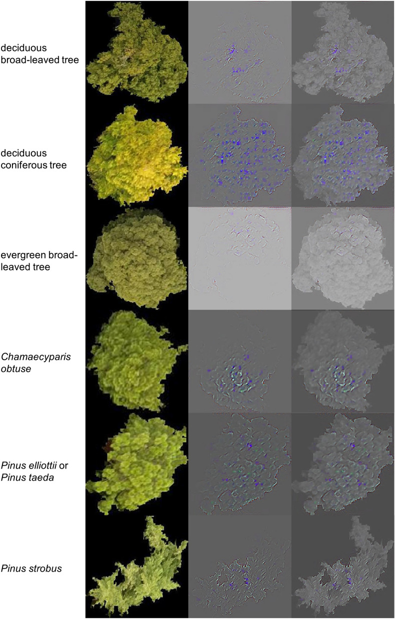
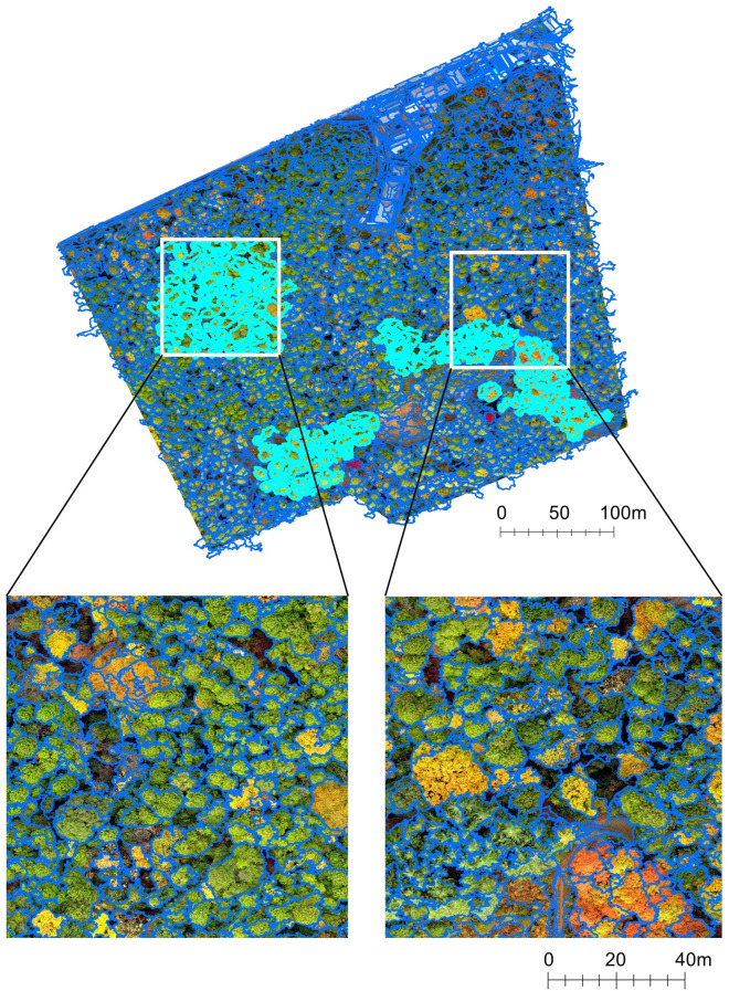
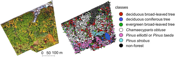
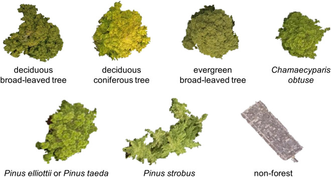
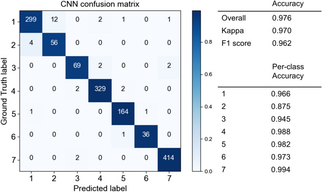
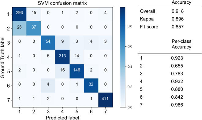
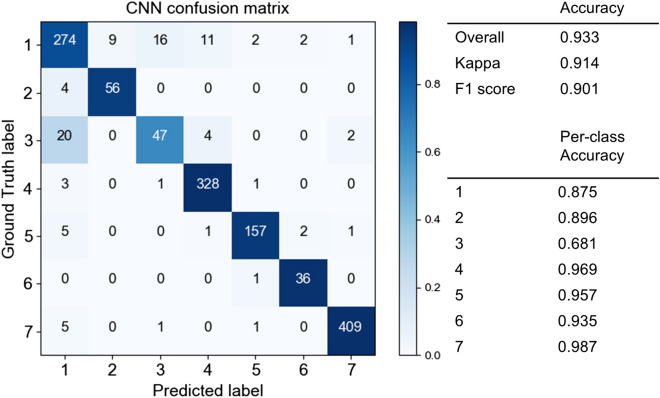
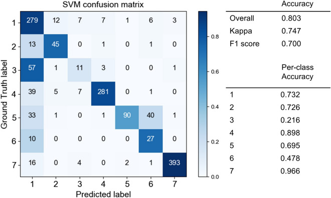
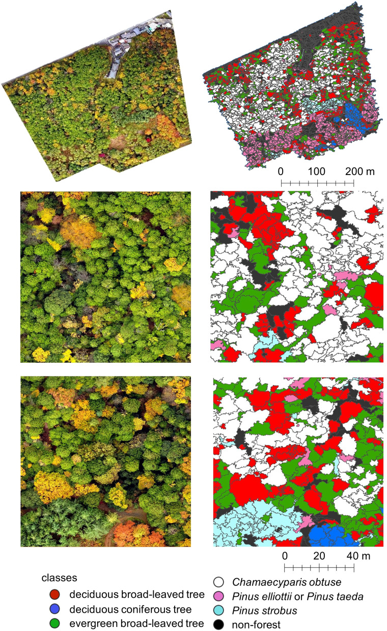
The identification and mapping of trees via remotely sensed data for application in forest management is an active area of research. Previously proposed methods using airborne and hyperspectral sensors can identify tree species with high accuracy but are costly and are thus unsuitable for small-scale forest managers. In this work, we constructed a machine vision system for tree identification and mapping using Red-Green-Blue (RGB) image taken by an unmanned aerial vehicle (UAV) and a convolutional neural network (CNN). In this system, we first calculated the slope from the three-dimensional model obtained by the UAV, and segmented the UAV RGB photograph of the forest into several tree crown objects automatically using colour and three-dimensional information and the slope model, and lastly applied object-based CNN classification for each crown image. This system succeeded in classifying seven tree classes, including several tree species with more than 90% accuracy. The guided gradient-weighted class activation mapping (Guided Grad-CAM) showed that the CNN classified trees according to their shapes and leaf contrasts, which enhances the potential of the system for classifying individual trees with similar colours in a cost-effective manner-a useful feature for forest management.

摘要

利用遥感数据进行树木识别和制图,以应用于森林管理,这是一个活跃的研究领域。之前使用机载和高光谱传感器提出的方法可以非常准确地识别树种,但成本高昂,因此不适合小规模的森林管理者。在这项工作中,我们使用无人驾驶飞行器 (UAV) 拍摄的红-绿-蓝 (RGB) 图像和卷积神经网络 (CNN) 构建了用于树木识别和制图的机器视觉系统。在该系统中,我们首先计算了由 UAV 获得的三维模型的斜率,并使用颜色、三维信息和斜率模型自动将森林的 UAV RGB 照片分割成几个树冠物体,最后对每个树冠图像应用基于对象的 CNN 分类。该系统成功地对包括几种树木物种在内的 7 个树木类进行了分类,分类准确率超过 90%。引导梯度加权类激活映射(Guided Grad-CAM)表明,CNN 根据树木的形状和叶子对比度进行分类,这增强了该系统以经济有效的方式对颜色相似的单个树木进行分类的潜力,这是森林管理的一个有用特征。

https://cdn.ncbi.nlm.nih.gov/pmc/blobs/a963/7806907/70318c1b13f7/41598_2020_79653_Fig11_HTML.jpg
https://cdn.ncbi.nlm.nih.gov/pmc/blobs/a963/7806907/d3415c46c3d7/41598_2020_79653_Fig1_HTML.jpg
https://cdn.ncbi.nlm.nih.gov/pmc/blobs/a963/7806907/19c1332bd20f/41598_2020_79653_Fig2_HTML.jpg
https://cdn.ncbi.nlm.nih.gov/pmc/blobs/a963/7806907/5dbafc955e3f/41598_2020_79653_Fig3_HTML.jpg
https://cdn.ncbi.nlm.nih.gov/pmc/blobs/a963/7806907/dff33bca5ad2/41598_2020_79653_Fig4_HTML.jpg
https://cdn.ncbi.nlm.nih.gov/pmc/blobs/a963/7806907/f2c4167baaa6/41598_2020_79653_Fig5_HTML.jpg
https://cdn.ncbi.nlm.nih.gov/pmc/blobs/a963/7806907/d89fa400ab3e/41598_2020_79653_Fig6_HTML.jpg
https://cdn.ncbi.nlm.nih.gov/pmc/blobs/a963/7806907/43c09b576c39/41598_2020_79653_Fig7_HTML.jpg
https://cdn.ncbi.nlm.nih.gov/pmc/blobs/a963/7806907/d93f85eea6d9/41598_2020_79653_Fig8_HTML.jpg
https://cdn.ncbi.nlm.nih.gov/pmc/blobs/a963/7806907/6a1d734738e7/41598_2020_79653_Fig9_HTML.jpg
https://cdn.ncbi.nlm.nih.gov/pmc/blobs/a963/7806907/7f4cd609adad/41598_2020_79653_Fig10_HTML.jpg
https://cdn.ncbi.nlm.nih.gov/pmc/blobs/a963/7806907/70318c1b13f7/41598_2020_79653_Fig11_HTML.jpg

相似文献

1
Explainable identification and mapping of trees using UAV RGB image and deep learning.利用无人机 RGB 图像和深度学习进行可解释的树木识别和制图。
Sci Rep. 2021 Jan 13;11(1):903. doi: 10.1038/s41598-020-79653-9.
2
Assessment of CNN-Based Methods for Individual Tree Detection on Images Captured by RGB Cameras Attached to UAVs.基于卷积神经网络的方法在搭载于无人机的 RGB 相机获取的图像上进行单木检测的评估。
Sensors (Basel). 2019 Aug 18;19(16):3595. doi: 10.3390/s19163595.
3
Deep learning based banana plant detection and counting using high-resolution red-green-blue (RGB) images collected from unmanned aerial vehicle (UAV).基于深度学习的香蕉种植检测与计数:使用无人机采集的高分辨率红绿蓝(RGB)图像。
PLoS One. 2019 Oct 17;14(10):e0223906. doi: 10.1371/journal.pone.0223906. eCollection 2019.
4
Identification of tree species based on the fusion of UAV hyperspectral image and LiDAR data in a coniferous and broad-leaved mixed forest in Northeast China.基于无人机高光谱图像与激光雷达数据融合的中国东北针叶阔叶混交林树种识别
Front Plant Sci. 2022 Sep 23;13:964769. doi: 10.3389/fpls.2022.964769. eCollection 2022.
5
Classification of riparian forest species and health condition using multi-temporal and hyperspatial imagery from unmanned aerial system.利用无人机系统的多时间和高空间分辨率影像对河岸森林物种和健康状况进行分类
Environ Monit Assess. 2016 Mar;188(3):146. doi: 10.1007/s10661-015-4996-2. Epub 2016 Feb 5.
6
A framework for precisely thinning planning in a managed pure Chinese fir forest based on UAV remote sensing.基于无人机遥感的精准间伐规划框架在人工纯马尾松林的应用。
Sci Total Environ. 2023 Feb 20;860:160482. doi: 10.1016/j.scitotenv.2022.160482. Epub 2022 Dec 2.
7
UAVs, Hyperspectral Remote Sensing, and Machine Learning Revolutionizing Reef Monitoring.无人机、高光谱遥感和机器学习正在彻底改变珊瑚礁监测。
Sensors (Basel). 2018 Jun 25;18(7):2026. doi: 10.3390/s18072026.
8
Convolutional Neural Networks enable efficient, accurate and fine-grained segmentation of plant species and communities from high-resolution UAV imagery.卷积神经网络可实现从高分辨率无人机图像中对植物物种和群落进行高效、准确和精细的分割。
Sci Rep. 2019 Nov 27;9(1):17656. doi: 10.1038/s41598-019-53797-9.
9
Mapping and characterizing selected canopy tree species at the Angkor World Heritage site in Cambodia using aerial data.利用航空数据对柬埔寨吴哥世界遗产地选定的冠层树种进行测绘和特征描述。
PLoS One. 2015 Apr 22;10(4):e0121558. doi: 10.1371/journal.pone.0121558. eCollection 2015.
10
Proposing UGV and UAV Systems for 3D Mapping of Orchard Environments.提出用于果园环境三维测绘的地面机器人和无人机系统。
Sensors (Basel). 2022 Feb 17;22(4):1571. doi: 10.3390/s22041571.

引用本文的文献

1
Effective integration of drone technology for mapping and managing palm species in the Peruvian Amazon.无人机技术在秘鲁亚马逊地区对棕榈物种进行测绘和管理中的有效整合。
Nat Commun. 2025 Apr 22;16(1):3764. doi: 10.1038/s41467-025-58358-5.
2
Binocular stereo vision-based relative positioning algorithm for drone swarm.基于双目立体视觉的无人机群相对定位算法
Sci Rep. 2025 Jan 27;15(1):3402. doi: 10.1038/s41598-025-86981-1.
3
Forest pest monitoring and early warning using UAV remote sensing and computer vision techniques.利用无人机遥感和计算机视觉技术进行森林病虫害监测与早期预警。

本文引用的文献

1
Assessment of CNN-Based Methods for Individual Tree Detection on Images Captured by RGB Cameras Attached to UAVs.基于卷积神经网络的方法在搭载于无人机的 RGB 相机获取的图像上进行单木检测的评估。
Sensors (Basel). 2019 Aug 18;19(16):3595. doi: 10.3390/s19163595.
Sci Rep. 2025 Jan 2;15(1):401. doi: 10.1038/s41598-024-84464-3.
4
From Industry 5.0 to Forestry 5.0: Bridging the gap with Human-Centered Artificial Intelligence.从工业5.0到林业5.0:借助以人为本的人工智能弥合差距。
Curr For Rep. 2024;10(6):442-455. doi: 10.1007/s40725-024-00231-7. Epub 2024 Sep 11.
5
Individual canopy tree species maps for the National Ecological Observatory Network.国家生态观测网络的单树冠树种图。
PLoS Biol. 2024 Jul 16;22(7):e3002700. doi: 10.1371/journal.pbio.3002700. eCollection 2024 Jul.
6
Mangrove Species Classification from Unmanned Aerial Vehicle Hyperspectral Images Using Object-Oriented Methods Based on Feature Combination and Optimization.基于特征组合与优化的面向对象方法从无人机高光谱图像中进行红树林物种分类
Sensors (Basel). 2024 Jun 24;24(13):4108. doi: 10.3390/s24134108.
7
Deep Learning Super-Resolution Technique Based on Magnetic Resonance Imaging for Application of Image-Guided Diagnosis and Surgery of Trigeminal Neuralgia.基于磁共振成像的深度学习超分辨率技术在三叉神经痛图像引导诊断与手术中的应用
Life (Basel). 2024 Mar 7;14(3):355. doi: 10.3390/life14030355.
8
Lightweight air-to-air unmanned aerial vehicle target detection model.轻型空空无人机目标检测模型
Sci Rep. 2024 Jan 31;14(1):2609. doi: 10.1038/s41598-024-53181-2.
9
Consumer-grade UAV imagery facilitates semantic segmentation of species-rich savanna tree layers.消费级无人机影像有助于物种丰富的热带稀树草原树层层的语义分割。
Sci Rep. 2023 Aug 24;13(1):13892. doi: 10.1038/s41598-023-40989-7.
10
Machine learning assisted remote forestry health assessment: a comprehensive state of the art review.机器学习辅助的远程林业健康评估:全面的技术现状综述
Front Plant Sci. 2023 Jun 2;14:1139232. doi: 10.3389/fpls.2023.1139232. eCollection 2023.