Liu Changhong, Yang Cuiping, Yang Qi, Wang Jiao
Institute of Environment Remediation and Human Health, Southwest Forestry University, Kunming, 650224, Yunnan, China.
College of Ecology and Environment, Southwest Forestry University, Kunming, 650224, Yunnan, China.
Sci Rep. 2021 Jan 14;11(1):1280. doi: 10.1038/s41598-020-80527-3.
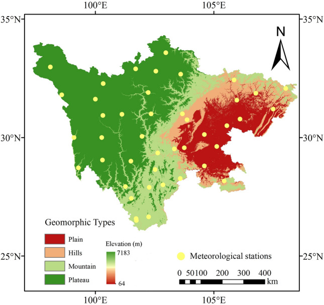
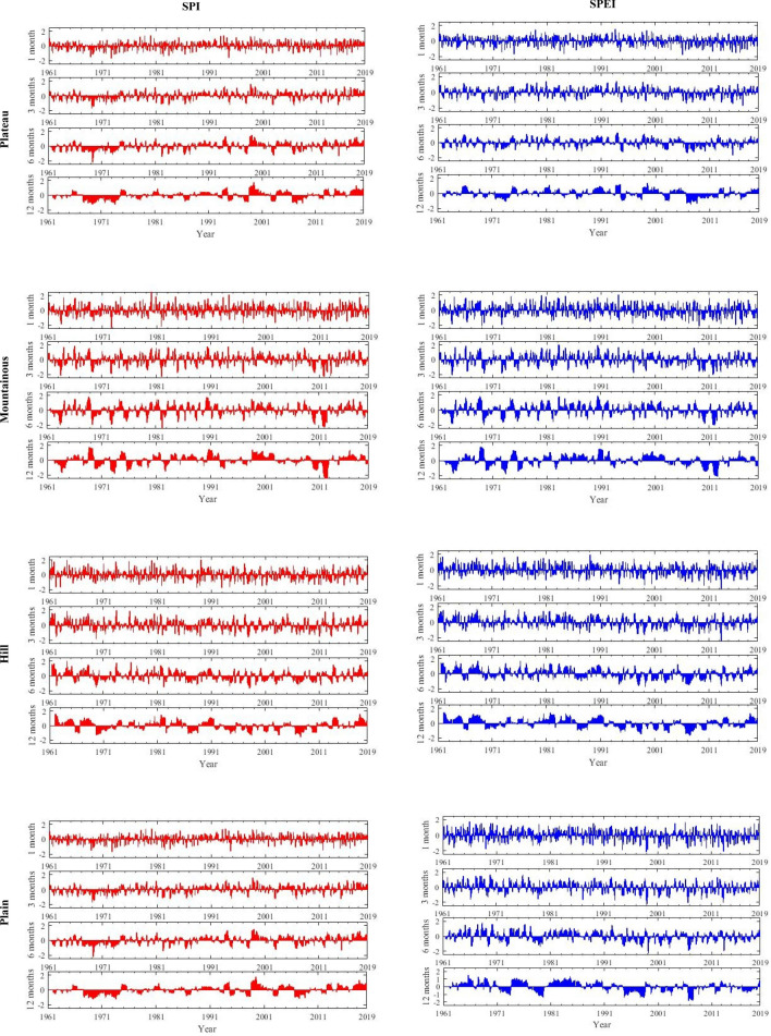
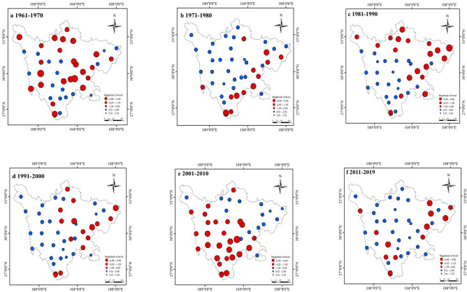
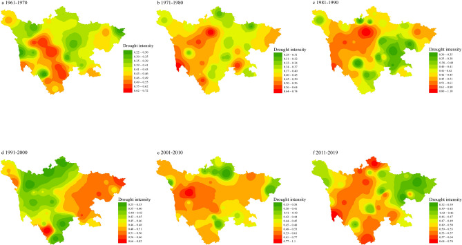
Drought refers to a meteorological disaster that causes insufficient soil moisture and damage to crop water balance due to long-term lack of precipitation. With the increasing shortage of water resources, drought has become one of the hot issues of global concern. The standardized precipitation index (SPI) and standardized precipitation evapotranspiration index (SPEI) can effectively reflect the changes in drought characteristics of different geomorphologies in Sichuan on time and space scales, to explore the difference in drought characteristics between different physiognomy types in Sichuan Province, We calculated the SPI and SPEI values based on the data of 44 meteorological stations in Sichuan Province from 1961 to 2019 and used Mann-Kendall trend test and multivariable linear regression method (MLR) to quantify the significance of the drought characteristic trends at different time and space scales. The results as follow: (1) The SPEI drought trend in plain and hilly regions was greater than that in plateau and mountain regions on all time scales (- 0.039 year for 1-month in hilly, - 0.035 year for 1-month in plain, - 0.14 year for 1-month in plateau, - 0.026 year for 1-month in mountain) and the magnitude of trend of eastern (- 4.4 to 0.1 year) was lager than western (- 2.1 to 2.7 year), means that the drought trends transfer from northwest to east. (2) The drought intensity in the western region gradually increased (0.54-1.05) and drought events mainly occurred in the southwest plateau and central mountainous regions (24-47 times), means that drought meteorological hotspots were mainly concentrated in the Sichuan basin. (3) The MLR indicated altitude (H) is not the main influencing factor that causes the spatial unevenness of precipitation in Sichuan Province, but altitude (H), temperature (T), longitude (L) and latitude (L) can co-determined the precipitation. The results of this study are instructive and practical for drought assessment, risk management and application decision-making in Sichuan Province, and have guiding significance for agricultural disaster prevention, mitigation and agricultural irrigation in Sichuan Province.
干旱是指由于长期缺乏降水导致土壤水分不足和作物水分平衡受损的一种气象灾害。随着水资源短缺问题日益严重,干旱已成为全球关注的热点问题之一。标准化降水指数(SPI)和标准化降水蒸散指数(SPEI)能够有效反映四川省不同地貌干旱特征在时空尺度上的变化。为探究四川省不同地貌类型之间干旱特征的差异,我们基于四川省44个气象站1961—2019年的数据计算了SPI和SPEI值,并采用曼-肯德尔趋势检验和多元线性回归方法(MLR)对不同时空尺度下干旱特征趋势的显著性进行了量化。结果如下:(1)在所有时间尺度上,平原和丘陵地区的SPEI干旱趋势均大于高原和山区(丘陵地区1个月尺度为-0.039/年,平原地区1个月尺度为-0.035/年,高原地区1个月尺度为-0.014/年,山区1个月尺度为-0.026/年),且东部地区(-4.4至0.1/年)的趋势幅度大于西部地区(-2.1至2.7/年),这意味着干旱趋势由西北向东部转移。(2)西部地区干旱强度逐渐增加(0.54 - 1.05),干旱事件主要发生在西南高原和中部山区(24 - 47次),这意味着干旱气象热点主要集中在四川盆地。(3)MLR表明海拔高度(H)不是导致四川省降水空间不均一性的主要影响因素,但海拔高度(H)、温度(T)、经度(L)和纬度(L)可共同决定降水量。本研究结果对四川省干旱评估、风险管理和应用决策具有指导意义,对四川省农业防灾减灾及农业灌溉具有指导作用。