• 文献检索
  • 文档翻译
  • 深度研究
  • 学术资讯
  • Suppr Zotero 插件Zotero 插件
  • 邀请有礼
  • 套餐&价格
  • 历史记录
应用&插件
Suppr Zotero 插件Zotero 插件浏览器插件Mac 客户端Windows 客户端微信小程序
定价
高级版会员购买积分包购买API积分包
服务
文献检索文档翻译深度研究API 文档MCP 服务
关于我们
关于 Suppr公司介绍联系我们用户协议隐私条款
关注我们

Suppr 超能文献

核心技术专利:CN118964589B侵权必究
粤ICP备2023148730 号-1Suppr @ 2026

文献检索

告别复杂PubMed语法,用中文像聊天一样搜索,搜遍4000万医学文献。AI智能推荐,让科研检索更轻松。

立即免费搜索

文件翻译

保留排版,准确专业,支持PDF/Word/PPT等文件格式,支持 12+语言互译。

免费翻译文档

深度研究

AI帮你快速写综述,25分钟生成高质量综述,智能提取关键信息,辅助科研写作。

立即免费体验

通过水文和水力模型量化地震引起的地表高程变化的淹没影响。

Quantifying the inundation impacts of earthquake-induced surface elevation change by hydrological and hydraulic modeling.

作者信息

Ouyang Mao, Ito Yuka, Tokunaga Tomochika

机构信息

Department of Environment Systems, The University of Tokyo, Kashiwa, 277-8563, Japan.

出版信息

Sci Rep. 2021 Feb 19;11(1):4269. doi: 10.1038/s41598-021-83309-7.

DOI:10.1038/s41598-021-83309-7
PMID:33608596
原文链接:https://pmc.ncbi.nlm.nih.gov/articles/PMC7895827/
Abstract

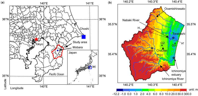
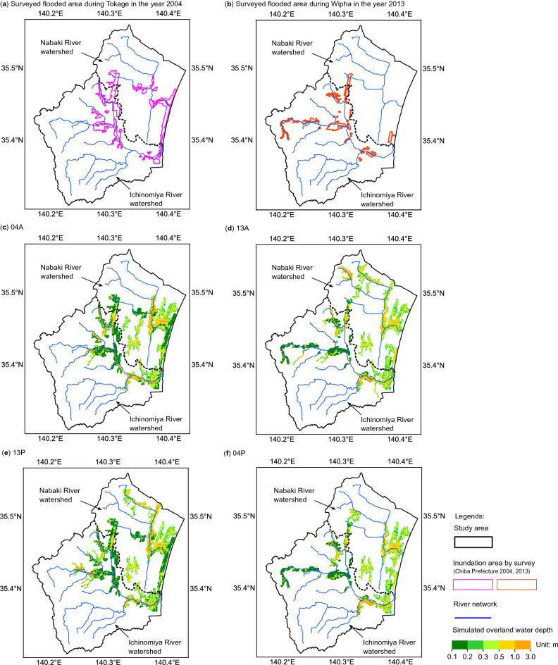
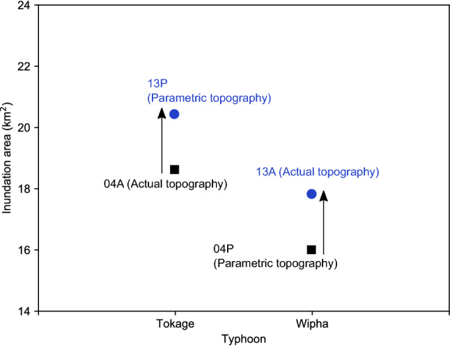
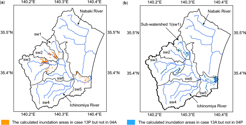
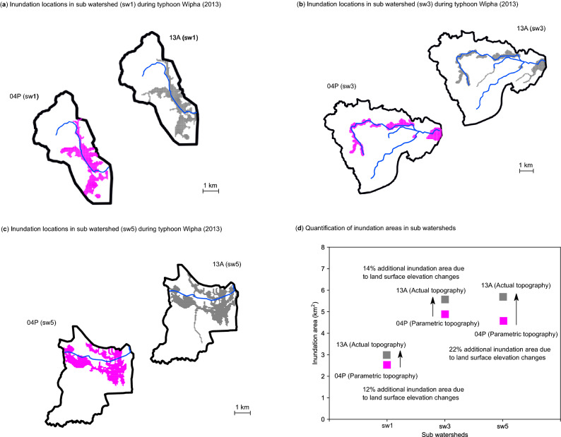
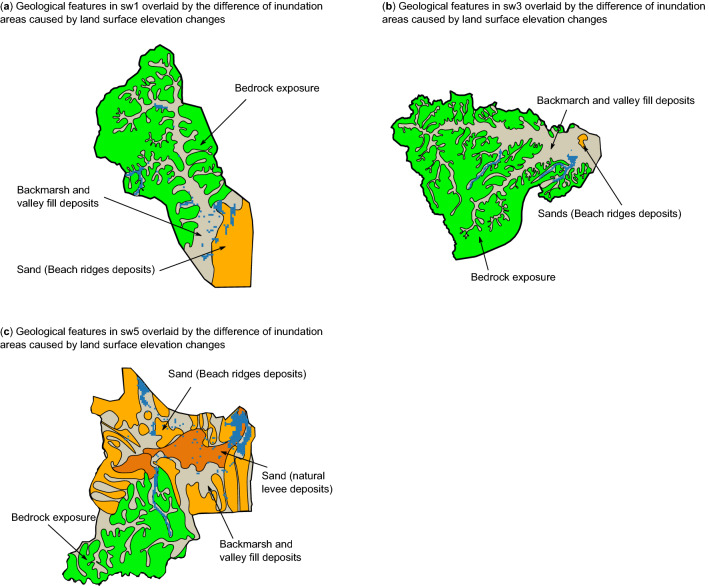
Current estimates of flood hazards are often based on the assumption that topography is static. When tectonic and/or anthropogenic processes change the land surface elevation, the spatial patterns of floods might also change. Here, we employ the hydrological and hydraulic modeling to simulate floods in the Kujukuri Plain, Japan, in the years 2004 and 2013, when two severe floods occurred. In between the two floods, land surface elevations were changed by the 2011 Tohoku-Oki earthquake. The effects of land surface elevation changes on inundation areas were quantified by changing input topographies. Our results showed that, without taking into account land surface elevation changes, around 10% of inundation areas were underestimated at the time of flood events in the year 2013. The spatial distribution of inundation locations varied with local topographical features, for example, the areas with backmarsh and valley fill deposits were sensitive to the extent of inundation by land surface elevation changes. The sub-watershed near the coastal shoreline having below-zero meter elevation areas showed that the earthquake-induced land surface elevation changes exacerbated an additional 22% inundation area. This study suggests that the inundation areas will increase in catchments suffering severe settlements, which highlights the necessity of taking into account the spatio-temporal changes of land surface elevations on the assessment of flood hazards.

摘要

目前对洪水灾害的估计通常基于地形是静态的这一假设。当构造和/或人为过程改变陆地表面高程时,洪水的空间格局也可能发生变化。在此,我们利用水文和水力模型来模拟日本九十九里平原在2004年和2013年发生两次严重洪水时的洪水情况。在这两次洪水之间,陆地表面高程因2011年东北地震而发生了变化。通过改变输入地形来量化陆地表面高程变化对淹没区域的影响。我们的结果表明,如果不考虑陆地表面高程变化,在2013年洪水事件发生时,约10%的淹没区域被低估。淹没位置的空间分布随局部地形特征而变化,例如,有河漫滩和谷底沉积物的区域对陆地表面高程变化引起的淹没范围很敏感。沿海岸线附近海拔低于零米区域的子流域表明,地震引起的陆地表面高程变化使淹没面积额外增加了22%。这项研究表明,在遭受严重沉降的集水区,淹没面积将会增加,这突出了在评估洪水灾害时考虑陆地表面高程时空变化的必要性。

https://cdn.ncbi.nlm.nih.gov/pmc/blobs/f7b2/7895827/a15da2e94228/41598_2021_83309_Fig7_HTML.jpg
https://cdn.ncbi.nlm.nih.gov/pmc/blobs/f7b2/7895827/34dbeae17c5a/41598_2021_83309_Fig1_HTML.jpg
https://cdn.ncbi.nlm.nih.gov/pmc/blobs/f7b2/7895827/42aab41520cd/41598_2021_83309_Fig2_HTML.jpg
https://cdn.ncbi.nlm.nih.gov/pmc/blobs/f7b2/7895827/d45ad3520e43/41598_2021_83309_Fig3_HTML.jpg
https://cdn.ncbi.nlm.nih.gov/pmc/blobs/f7b2/7895827/af330d24ef88/41598_2021_83309_Fig4_HTML.jpg
https://cdn.ncbi.nlm.nih.gov/pmc/blobs/f7b2/7895827/b29b73c4a0a0/41598_2021_83309_Fig5_HTML.jpg
https://cdn.ncbi.nlm.nih.gov/pmc/blobs/f7b2/7895827/09d40dfca117/41598_2021_83309_Fig6_HTML.jpg
https://cdn.ncbi.nlm.nih.gov/pmc/blobs/f7b2/7895827/a15da2e94228/41598_2021_83309_Fig7_HTML.jpg

相似文献

1
Quantifying the inundation impacts of earthquake-induced surface elevation change by hydrological and hydraulic modeling.通过水文和水力模型量化地震引起的地表高程变化的淹没影响。
Sci Rep. 2021 Feb 19;11(1):4269. doi: 10.1038/s41598-021-83309-7.
2
A study of land use changes and its impacts on flood inundation in the Konkoure River Basin, Republic of Guinea.对几内亚共和国孔库雷河流域土地利用变化及其对洪水淹没的影响的研究。
Environ Monit Assess. 2024 Jan 29;196(2):212. doi: 10.1007/s10661-024-12371-1.
3
Coupling hydroclimate-hydraulic-sedimentation models to estimate flood inundation and sediment transport during extreme flood events under a changing climate.耦合水文气候-水力学-泥沙模型估算气候变化下极端洪水事件中的洪水泛滥和泥沙输移。
Sci Total Environ. 2020 Oct 20;740:140117. doi: 10.1016/j.scitotenv.2020.140117. Epub 2020 Jun 10.
4
The land morphology approach to flood risk mapping: An application to Portugal.基于地貌的洪水风险制图方法:在葡萄牙的应用。
J Environ Manage. 2017 May 15;193:172-187. doi: 10.1016/j.jenvman.2017.01.077.
5
Evacuation planning for plausible worst case inundation scenarios in Honolulu, Hawaii.夏威夷檀香山针对可能出现的最严重洪水淹没情况的疏散规划。
J Emerg Manag. 2015 Mar-Apr;13(2):93-108. doi: 10.5055/jem.2015.0223.
6
Analysis of flood inundation in ungauged basins based on multi-source remote sensing data.基于多源遥感数据的无资料流域洪水淹没分析。
Environ Monit Assess. 2018 Feb 9;190(3):129. doi: 10.1007/s10661-018-6499-4.
7
A rapid flood inundation model for urban flood analyses.一种用于城市洪水分析的快速洪水淹没模型。
MethodsX. 2023 Apr 26;10:102202. doi: 10.1016/j.mex.2023.102202. eCollection 2023.
8
Does flooding get worse with subsiding land? Investigating the impacts of land subsidence on flood inundation from Hurricane Harvey.随着陆地沉降,洪水会变得更严重吗?调查地面沉降对哈维飓风引发的洪水淹没的影响。
Sci Total Environ. 2023 Mar 20;865:161072. doi: 10.1016/j.scitotenv.2022.161072. Epub 2022 Dec 27.
9
Flood hazard mapping and assessment in data-scarce Nyaungdon area, Myanmar.缅甸 Nyaungdon 地区数据匮乏地区的洪水灾害图绘制与评估。
PLoS One. 2019 Nov 26;14(11):e0224558. doi: 10.1371/journal.pone.0224558. eCollection 2019.
10
Extreme rainfall-induced urban flood monitoring and damage assessment in Wuhan (China) and Kumamoto (Japan) cities using Google Earth Engine.利用谷歌地球引擎监测武汉(中国)和熊本(日本)城市强降雨引发的城市洪水及灾害评估
Environ Monit Assess. 2022 May 5;194(6):402. doi: 10.1007/s10661-022-10076-x.

本文引用的文献

1
Floodplain inundation spectrum across the United States.美国洪泛区淹没范围图谱
Nat Commun. 2019 Nov 15;10(1):5194. doi: 10.1038/s41467-019-13184-4.
2
New elevation data triple estimates of global vulnerability to sea-level rise and coastal flooding.新的海拔数据使全球海平面上升和沿海洪灾脆弱性的估计增加两倍。
Nat Commun. 2019 Oct 29;10(1):4844. doi: 10.1038/s41467-019-12808-z.
3
Changing climate both increases and decreases European river floods.气候变化既增加了又减少了欧洲河流洪水。
Nature. 2019 Sep;573(7772):108-111. doi: 10.1038/s41586-019-1495-6. Epub 2019 Aug 28.
4
New estimates of flood exposure in developing countries using high-resolution population data.利用高分辨率人口数据对发展中国家洪水暴露情况的新估计。
Nat Commun. 2019 Apr 18;10(1):1814. doi: 10.1038/s41467-019-09282-y.
5
Mechanism of subsidence of the Northeast Japan forearc during the late period of a gigantic earthquake cycle.日本东北部弧前区在巨大地震周期后期的沉降机制。
Sci Rep. 2019 Apr 5;9(1):5726. doi: 10.1038/s41598-019-42169-y.
6
Sediment replenishment combined with an artificial flood improves river habitats downstream of a dam.泥沙补给与人工洪水相结合可改善大坝下游的河流栖息地。
Sci Rep. 2019 Mar 26;9(1):5176. doi: 10.1038/s41598-019-41575-6.
7
Dynamic flood modeling essential to assess the coastal impacts of climate change.动态洪水建模对于评估气候变化对沿海地区的影响至关重要。
Sci Rep. 2019 Mar 13;9(1):4309. doi: 10.1038/s41598-019-40742-z.
8
High-tide flooding disrupts local economic activity.高潮位洪水扰乱了当地的经济活动。
Sci Adv. 2019 Feb 15;5(2):eaau2736. doi: 10.1126/sciadv.aau2736. eCollection 2019 Feb.
9
Novel Hybrid Evolutionary Algorithms for Spatial Prediction of Floods.新型混合进化算法在洪水空间预测中的应用。
Sci Rep. 2018 Oct 18;8(1):15364. doi: 10.1038/s41598-018-33755-7.
10
Flood inundation assessment for the Hanoi Central Area, Vietnam under historical and extreme rainfall conditions.越南河内市中心区在历史和极端降雨条件下的洪水淹没评估。
Sci Rep. 2018 Aug 22;8(1):12623. doi: 10.1038/s41598-018-30024-5.