• 文献检索
  • 文档翻译
  • 深度研究
  • 学术资讯
  • Suppr Zotero 插件Zotero 插件
  • 邀请有礼
  • 套餐&价格
  • 历史记录
应用&插件
Suppr Zotero 插件Zotero 插件浏览器插件Mac 客户端Windows 客户端微信小程序
定价
高级版会员购买积分包购买API积分包
服务
文献检索文档翻译深度研究API 文档MCP 服务
关于我们
关于 Suppr公司介绍联系我们用户协议隐私条款
关注我们

Suppr 超能文献

核心技术专利:CN118964589B侵权必究
粤ICP备2023148730 号-1Suppr @ 2026

文献检索

告别复杂PubMed语法,用中文像聊天一样搜索,搜遍4000万医学文献。AI智能推荐,让科研检索更轻松。

立即免费搜索

文件翻译

保留排版,准确专业,支持PDF/Word/PPT等文件格式,支持 12+语言互译。

免费翻译文档

深度研究

AI帮你快速写综述,25分钟生成高质量综述,智能提取关键信息,辅助科研写作。

立即免费体验

基于InSAR观测地表形变对加利福尼亚州圣华金谷地下水补给与流动的特征分析

Characterization of Groundwater Recharge and Flow in California's San Joaquin Valley From InSAR-Observed Surface Deformation.

作者信息

Neely Wesley R, Borsa Adrian A, Burney Jennifer A, Levy Morgan C, Silverii Francesca, Sneed Michelle

机构信息

Scripps Institution of Oceanography University of California San Diego La Jolla CA USA.

School of Global Policy and Strategy University of California San Diego La Jolla CA USA.

出版信息

Water Resour Res. 2021 Apr;57(4):e2020WR028451. doi: 10.1029/2020WR028451. Epub 2021 Apr 7.

DOI:10.1029/2020WR028451
PMID:33867591
原文链接:https://pmc.ncbi.nlm.nih.gov/articles/PMC8047915/
Abstract

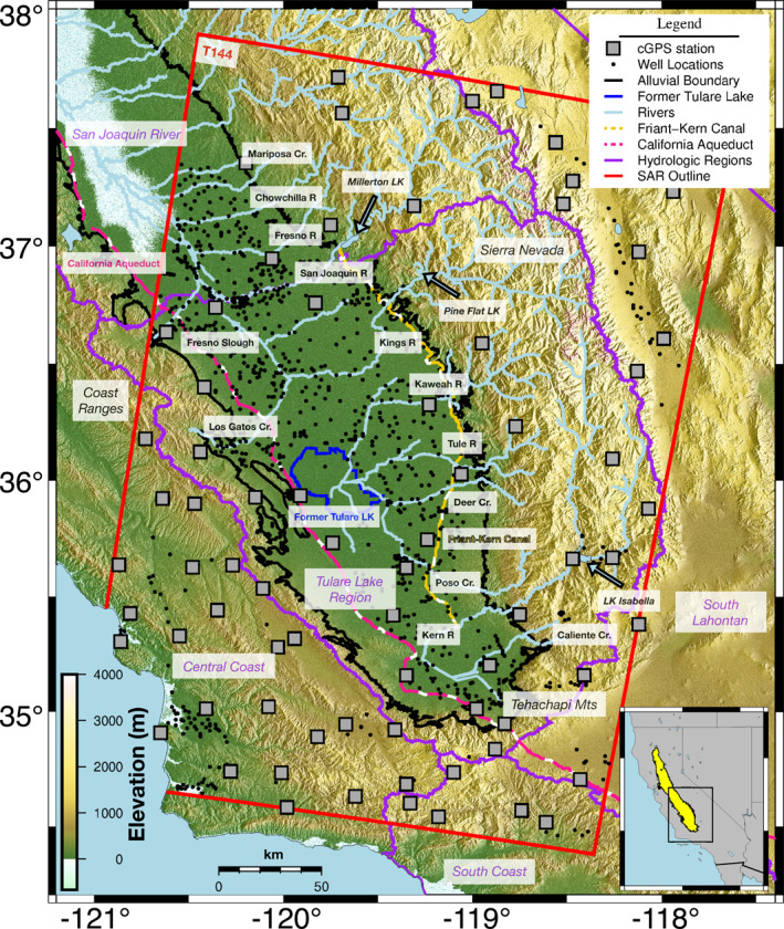
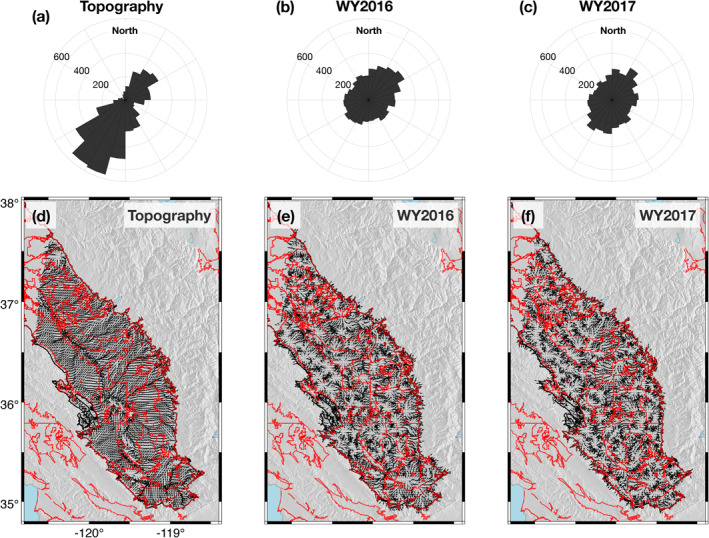
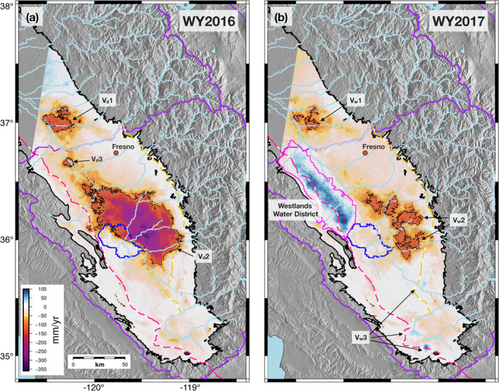
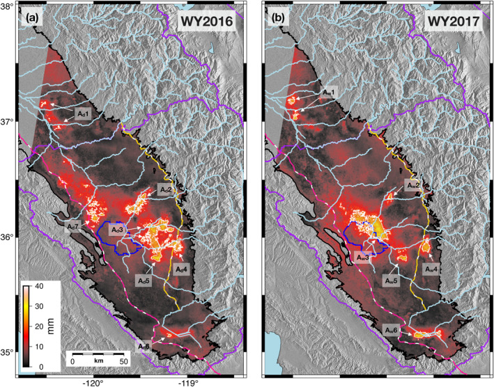
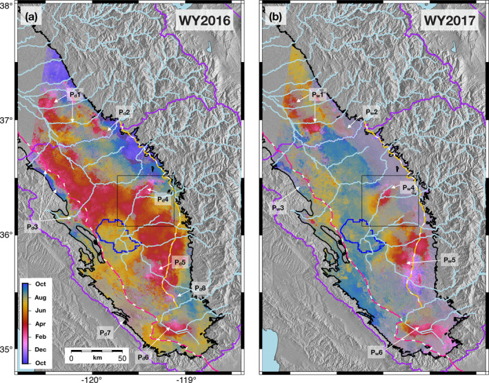
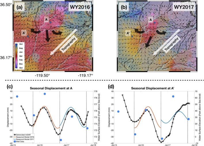
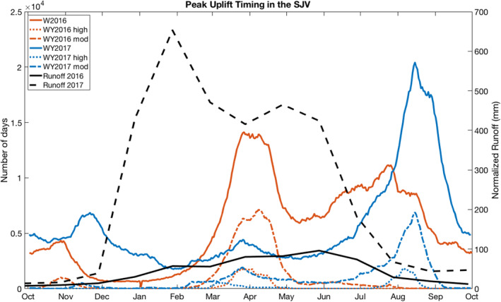
Surface deformation in California's Central Valley (CV) has long been linked to changes in groundwater storage. Recent advances in remote sensing have enabled the mapping of CV deformation and associated changes in groundwater resources at increasingly higher spatiotemporal resolution. Here, we use interferometric synthetic aperture radar (InSAR) from the Sentinel-1 missions, augmented by continuous Global Positioning System (cGPS) positioning, to characterize the surface deformation of the San Joaquin Valley (SJV, southern two-thirds of the CV) for consecutive dry (2016) and wet (2017) water years. We separate trends and seasonal oscillations in deformation time series and interpret them in the context of surface and groundwater hydrology. We find that subsidence rates in 2016 (mean -42.0 mm/yr; peak -345 mm/yr) are twice that in 2017 (mean -20.4 mm/yr; peak -177 mm/yr), consistent with increased groundwater pumping in 2016 to offset the loss of surface-water deliveries. Locations of greatest subsidence migrated outwards from the valley axis in the wetter 2017 water year, possibly reflecting a surplus of surface-water supplies in the lowest portions of the SJV. Patterns in the amplitude of seasonal deformation and the timing of peak seasonal uplift reveal entry points and potential pathways for groundwater recharge into the SJV and subsequent groundwater flow within the aquifer. This study provides novel insight into the SJV aquifer system that can be used to constrain groundwater flow and subsidence models, which has relevance to groundwater management in the context of California's 2014 Sustainable Groundwater Management Act (SGMA).

摘要

加利福尼亚中央谷地(CV)的地表变形长期以来一直与地下蓄水层的变化相关。遥感技术的最新进展使得能够以越来越高的时空分辨率绘制CV变形图以及相关的地下水资源变化图。在此,我们使用哨兵 - 1任务的干涉合成孔径雷达(InSAR),并辅以连续全球定位系统(cGPS)定位,来描述圣华金谷(SJV,CV的南三分之二)在连续干旱(2016年)和湿润(2017年)水年的地表变形情况。我们分离了变形时间序列中的趋势和季节性振荡,并结合地表水和地下水文情况对其进行解释。我们发现,2016年的沉降速率(平均 -42.0毫米/年;峰值 -345毫米/年)是2017年(平均 -20.4毫米/年;峰值 -177毫米/年)的两倍,这与2016年增加地下水抽取以抵消地表水供应减少的情况一致。在较湿润的2017水年,沉降最大的区域从谷底轴线向外迁移,这可能反映了圣华金谷最低区域地表水供应过剩。季节性变形幅度和季节性抬升峰值时间的模式揭示了地下水补给进入圣华金谷以及随后在含水层中流动的入口点和潜在路径。本研究为圣华金谷含水层系统提供了新的见解,可用于约束地下水流和沉降模型,这与加利福尼亚州2014年《可持续地下水管理法案》(SGMA)背景下的地下水管理相关。

https://cdn.ncbi.nlm.nih.gov/pmc/blobs/d83c/8047915/602e7bb20516/WRCR-57-e2020WR028451-g005.jpg
https://cdn.ncbi.nlm.nih.gov/pmc/blobs/d83c/8047915/cb9acd4e3d2a/WRCR-57-e2020WR028451-g006.jpg
https://cdn.ncbi.nlm.nih.gov/pmc/blobs/d83c/8047915/ad6085b6bf27/WRCR-57-e2020WR028451-g004.jpg
https://cdn.ncbi.nlm.nih.gov/pmc/blobs/d83c/8047915/7e7238f9648d/WRCR-57-e2020WR028451-g007.jpg
https://cdn.ncbi.nlm.nih.gov/pmc/blobs/d83c/8047915/c5e27df5d669/WRCR-57-e2020WR028451-g002.jpg
https://cdn.ncbi.nlm.nih.gov/pmc/blobs/d83c/8047915/d1d38ff14305/WRCR-57-e2020WR028451-g001.jpg
https://cdn.ncbi.nlm.nih.gov/pmc/blobs/d83c/8047915/e68502e4c503/WRCR-57-e2020WR028451-g003.jpg
https://cdn.ncbi.nlm.nih.gov/pmc/blobs/d83c/8047915/602e7bb20516/WRCR-57-e2020WR028451-g005.jpg

相似文献

1
Characterization of Groundwater Recharge and Flow in California's San Joaquin Valley From InSAR-Observed Surface Deformation.基于InSAR观测地表形变对加利福尼亚州圣华金谷地下水补给与流动的特征分析
Water Resour Res. 2021 Apr;57(4):e2020WR028451. doi: 10.1029/2020WR028451. Epub 2021 Apr 7.
2
Groundwater Loss and Aquifer System Compaction in San Joaquin Valley During 2012-2015 Drought.2012 - 2015年干旱期间圣华金河谷的地下水流失与含水层系统压实
J Geophys Res Solid Earth. 2019 Mar;124(3):3127-3143. doi: 10.1029/2018JB016083. Epub 2019 Mar 18.
3
Sustained Groundwater Loss in California's Central Valley Exacerbated by Intense Drought Periods.加利福尼亚中央谷地持续的地下水流失因严重干旱期而加剧。
Water Resour Res. 2018 Jul;54(7):4449-4460. doi: 10.1029/2017WR022250. Epub 2018 Jul 4.
4
From fallow ground to common ground: Perspectives on future land uses in the San Joaquin valley under sustainable groundwater management.从休耕地到公共用地:可持续地下水管理下圣华金河谷未来土地利用的展望
J Environ Manage. 2023 May 1;333:117226. doi: 10.1016/j.jenvman.2023.117226. Epub 2023 Feb 7.
5
Uplift and seismicity driven by groundwater depletion in central California.地下水枯竭引发的中央加利福尼亚州的抬升和地震活动。
Nature. 2014 May 22;509(7501):483-6. doi: 10.1038/nature13275. Epub 2014 May 14.
6
Machine learning based downscaling of GRACE-estimated groundwater in Central Valley, California.基于机器学习的加利福尼亚中央谷地GRACE估算地下水降尺度分析
Sci Total Environ. 2023 Mar 20;865:161138. doi: 10.1016/j.scitotenv.2022.161138. Epub 2022 Dec 28.
7
Land Subsidence and Its Relations with Sinkhole Activity in Karapınar Region, Turkey: A Multi-Sensor InSAR Time Series Study.土耳其卡拉皮纳尔地区的地面沉降及其与塌陷活动的关系:多传感器InSAR时间序列研究
Sensors (Basel). 2021 Jan 24;21(3):774. doi: 10.3390/s21030774.
8
Time-varying land subsidence detected by radar altimetry: California, Taiwan and north China.利用雷达测高法探测到的时变地面沉降:加利福尼亚、台湾和中国北方地区。
Sci Rep. 2016 Jun 21;6:28160. doi: 10.1038/srep28160.
9
Using Sentinel-1 and GRACE satellite data to monitor the hydrological variations within the Tulare Basin, California.利用哨兵-1号和GRACE卫星数据监测加利福尼亚州图莱里盆地内的水文变化。
Sci Rep. 2022 Mar 9;12(1):3867. doi: 10.1038/s41598-022-07650-1.
10
Improving multi-technique monitoring using Sentinel-1 and Cosmo-SkyMed data and upgrading groundwater model capabilities.利用 Sentinel-1 和 Cosmo-SkyMed 数据改进多技术监测,并提升地下水模型能力。
Sci Total Environ. 2020 Feb 10;703:134757. doi: 10.1016/j.scitotenv.2019.134757. Epub 2019 Nov 2.

引用本文的文献

1
Groundwater depletion in California's Central Valley accelerates during megadrought.加利福尼亚中央谷地的地下水枯竭在特大干旱期间加速。
Nat Commun. 2022 Dec 19;13(1):7825. doi: 10.1038/s41467-022-35582-x.
2
Using Sentinel-1 and GRACE satellite data to monitor the hydrological variations within the Tulare Basin, California.利用哨兵-1号和GRACE卫星数据监测加利福尼亚州图莱里盆地内的水文变化。
Sci Rep. 2022 Mar 9;12(1):3867. doi: 10.1038/s41598-022-07650-1.

本文引用的文献

1
Groundwater Loss and Aquifer System Compaction in San Joaquin Valley During 2012-2015 Drought.2012 - 2015年干旱期间圣华金河谷的地下水流失与含水层系统压实
J Geophys Res Solid Earth. 2019 Mar;124(3):3127-3143. doi: 10.1029/2018JB016083. Epub 2019 Mar 18.
2
Sustained Groundwater Loss in California's Central Valley Exacerbated by Intense Drought Periods.加利福尼亚中央谷地持续的地下水流失因严重干旱期而加剧。
Water Resour Res. 2018 Jul;54(7):4449-4460. doi: 10.1029/2017WR022250. Epub 2018 Jul 4.
3
Short-lived pause in Central California subsidence after heavy winter precipitation of 2017.
2017 年冬季强降水后,加利福尼亚中部沉降的短暂停歇。
Sci Adv. 2018 Aug 29;4(8):eaar8144. doi: 10.1126/sciadv.aar8144. eCollection 2018 Aug.
4
Assessing Groundwater Depletion and Dynamics Using GRACE and InSAR: Potential and Limitations.利用GRACE和InSAR评估地下水消耗与动态变化:潜力与局限
Ground Water. 2016 Nov;54(6):768-780. doi: 10.1111/gwat.12453. Epub 2016 Aug 30.
5
Remote Hydrology. Ongoing drought-induced uplift in the western United States.远程水文学。美国西部持续干旱引发的抬升。
Science. 2014 Sep 26;345(6204):1587-90. doi: 10.1126/science.1260279. Epub 2014 Aug 21.
6
Groundwater depletion and sustainability of irrigation in the US High Plains and Central Valley.地下水枯竭与美国高平原和中央谷地灌溉的可持续性。
Proc Natl Acad Sci U S A. 2012 Jun 12;109(24):9320-5. doi: 10.1073/pnas.1200311109. Epub 2012 May 29.
7
Network approaches to two-dimensional phase unwrapping: intractability and two new algorithms.二维相位展开的网络方法:难解性与两种新算法。
J Opt Soc Am A Opt Image Sci Vis. 2000 Mar;17(3):401-14. doi: 10.1364/josaa.17.000401.