• 文献检索
  • 文档翻译
  • 深度研究
  • 学术资讯
  • Suppr Zotero 插件Zotero 插件
  • 邀请有礼
  • 套餐&价格
  • 历史记录
应用&插件
Suppr Zotero 插件Zotero 插件浏览器插件Mac 客户端Windows 客户端微信小程序
定价
高级版会员购买积分包购买API积分包
服务
文献检索文档翻译深度研究API 文档MCP 服务
关于我们
关于 Suppr公司介绍联系我们用户协议隐私条款
关注我们

Suppr 超能文献

核心技术专利:CN118964589B侵权必究
粤ICP备2023148730 号-1Suppr @ 2026

文献检索

告别复杂PubMed语法,用中文像聊天一样搜索,搜遍4000万医学文献。AI智能推荐,让科研检索更轻松。

立即免费搜索

文件翻译

保留排版,准确专业,支持PDF/Word/PPT等文件格式,支持 12+语言互译。

免费翻译文档

深度研究

AI帮你快速写综述,25分钟生成高质量综述,智能提取关键信息,辅助科研写作。

立即免费体验

2019 年台风“海贝思”全国洪水预报系统的适用性。

Applicability of a nationwide flood forecasting system for Typhoon Hagibis 2019.

机构信息

IIS, The University of Tokyo, Tokyo, Japan.

University of Massachusetts, Amherst, USA.

出版信息

Sci Rep. 2021 May 13;11(1):10213. doi: 10.1038/s41598-021-89522-8.

DOI:10.1038/s41598-021-89522-8
PMID:33986352
原文链接:https://pmc.ncbi.nlm.nih.gov/articles/PMC8119424/
Abstract

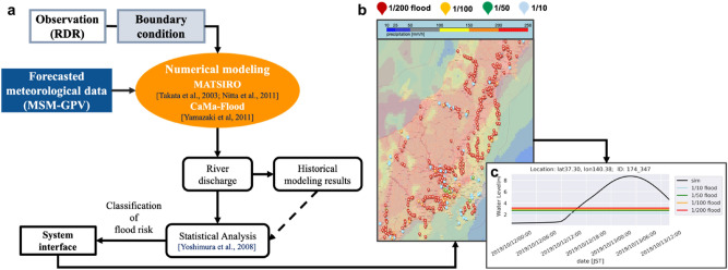
Floods can be devastating in densely populated regions along rivers, so attaining a longer forecast lead time with high accuracy is essential for protecting people and property. Although many techniques are used to forecast floods, sufficient validation of the use of a forecast system for operational alert purposes is lacking. In this study, we validated the flooding locations and times of dike breaking that had occurred during Typhoon Hagibis, which caused severe flooding in Japan in 2019. To achieve the goal of the study, we combined a hydrodynamic model with statistical analysis under forcing by a 39-h prediction of the Japan Meteorological Agency's Meso-scale model Grid Point Value (MSM-GPV) and obtained dike-break times for all flooded locations for validation. The results showed that this method was accurate in predicting floods at 130 locations, approximately 91.6% of the total of 142 flooded locations, with a lead time of approximately 32.75 h. In terms of precision, these successfully predicted locations accounted for 24.0% of the total of 542 locations under a flood warning, and on average, the predicted flood time was approximately 8.53 h earlier than a given dike-break time. More warnings were issued for major rivers with severe flooding, indicating that the system is sensitive to extreme flood events and can issue warnings for rivers subject to high risk of flooding.

摘要

洪水在河流沿岸人口密集地区可能造成毁灭性影响,因此,获得具有高精度的更长预报提前期对于保护人员和财产至关重要。尽管有许多技术用于洪水预报,但对于将预报系统用于业务警报目的的充分验证却缺乏。在这项研究中,我们验证了 2019 年在日本造成严重洪灾的台风“海贝思”期间决堤的洪水位置和时间。为了实现研究目标,我们结合了一个水动力模型和统计分析,根据日本气象厅中尺度模型格点值(MSM-GPV)的 39 小时预测进行强迫,获得了所有洪水泛滥地点的决堤时间进行验证。结果表明,这种方法在预测 130 个地点的洪水方面非常准确,大约占 142 个洪水泛滥地点的 91.6%,提前期约为 32.75 小时。在精度方面,这些成功预测的地点占 542 个发出洪水警报地点的 24.0%,平均而言,预测的洪水时间比给定的决堤时间早约 8.53 小时。更多的警报是针对严重洪水泛滥的主要河流发出的,这表明该系统对极端洪水事件敏感,并可以对存在高洪水风险的河流发出警报。

https://cdn.ncbi.nlm.nih.gov/pmc/blobs/c0d4/8119424/a6f920e22fb7/41598_2021_89522_Fig7_HTML.jpg
https://cdn.ncbi.nlm.nih.gov/pmc/blobs/c0d4/8119424/22c6b12e25a8/41598_2021_89522_Fig1_HTML.jpg
https://cdn.ncbi.nlm.nih.gov/pmc/blobs/c0d4/8119424/b65ebf49ba2b/41598_2021_89522_Fig2_HTML.jpg
https://cdn.ncbi.nlm.nih.gov/pmc/blobs/c0d4/8119424/931cc362b3a0/41598_2021_89522_Fig3_HTML.jpg
https://cdn.ncbi.nlm.nih.gov/pmc/blobs/c0d4/8119424/356c953c9a3d/41598_2021_89522_Fig4_HTML.jpg
https://cdn.ncbi.nlm.nih.gov/pmc/blobs/c0d4/8119424/8fb95d318fe7/41598_2021_89522_Fig5_HTML.jpg
https://cdn.ncbi.nlm.nih.gov/pmc/blobs/c0d4/8119424/7bc488389a4a/41598_2021_89522_Fig6_HTML.jpg
https://cdn.ncbi.nlm.nih.gov/pmc/blobs/c0d4/8119424/a6f920e22fb7/41598_2021_89522_Fig7_HTML.jpg

相似文献

1
Applicability of a nationwide flood forecasting system for Typhoon Hagibis 2019.2019 年台风“海贝思”全国洪水预报系统的适用性。
Sci Rep. 2021 May 13;11(1):10213. doi: 10.1038/s41598-021-89522-8.
2
Characteristics of Flood Fatalities in Japan's Typhoon Hagibis in 2019: Secondary Analysis of Public Data and Media Reports.2019年日本台风海贝斯引发洪水致死情况的特征:公共数据与媒体报道的二次分析
Disaster Med Public Health Prep. 2022 Aug;16(4):1512-1516. doi: 10.1017/dmp.2021.163. Epub 2021 Jul 21.
3
Assessing options for the development of surface water flood warning in England and Wales.评估在英格兰和威尔士开发地表水洪水预警的方案。
J Environ Manage. 2011 Dec;92(12):3038-48. doi: 10.1016/j.jenvman.2011.06.041. Epub 2011 Sep 8.
4
Impact of Flood Due to Typhoon Hagibis on Cardiovascular and Cerebrovascular Events in the Disaster Area of Nagano City: A Sub-Analysis Using Data From the SAVE Trial.台风海贝斯引发的洪水对长野市灾区心血管和脑血管事件的影响:基于SAVE试验数据的亚组分析
Disaster Med Public Health Prep. 2022 Mar 15;17:e113. doi: 10.1017/dmp.2022.16.
5
A nonstructural flood prevention measure for mitigating urban inundation impacts along with river flooding effects.一种非结构性防洪措施,可减轻城市洪灾影响以及河流泛滥的影响。
J Environ Manage. 2019 Dec 1;251:109553. doi: 10.1016/j.jenvman.2019.109553. Epub 2019 Sep 17.
6
Evaluation of the water pollution risk of dam and dike-break floods in the inundated area.评估淹没区大坝决堤洪水的水污染风险。
Environ Sci Pollut Res Int. 2022 Oct;29(50):76365-76377. doi: 10.1007/s11356-022-20742-9. Epub 2022 Jun 6.
7
A data-driven global flood forecasting system for medium to large rivers.一个用于大中型河流的基于数据驱动的全球洪水预报系统。
Sci Rep. 2024 Apr 18;14(1):8979. doi: 10.1038/s41598-024-59145-w.
8
Urban pluvial flood prediction: a case study evaluating radar rainfall nowcasts and numerical weather prediction models as model inputs.城市雨洪预测:以评估雷达降雨临近预报和数值天气预报模型作为模型输入的案例研究
Water Sci Technol. 2016 Dec;74(11):2599-2610. doi: 10.2166/wst.2016.474.
9
An exploration of factors affecting the long term psychological impact and deterioration of mental health in flooded households.对影响受洪水侵袭家庭长期心理影响及心理健康恶化因素的探究。
Environ Res. 2015 Jul;140:325-34. doi: 10.1016/j.envres.2015.04.008. Epub 2015 Apr 22.
10
Flood simulation using LISFLOOD and inundation effects: A case study of Typhoon In-Fa in Shanghai.使用LISFLOOD进行洪水模拟及淹没影响:以上海台风“烟花”为例
Sci Total Environ. 2024 Dec 1;954:176372. doi: 10.1016/j.scitotenv.2024.176372. Epub 2024 Sep 21.

本文引用的文献

1
Self-organizing maps of typhoon tracks allow for flood forecasts up to two days in advance.自组织风暴轨迹图可提前两天预测洪水。
Nat Commun. 2020 Apr 24;11(1):1983. doi: 10.1038/s41467-020-15734-7.
2
Trends in flood losses in Europe over the past 150 years.过去 150 年来欧洲洪灾损失的趋势。
Nat Commun. 2018 May 29;9(1):1985. doi: 10.1038/s41467-018-04253-1.
3
Long-distance transport of radioactive plume by nocturnal local winds.夜间局地风对放射性烟羽的远距离输送。
Sci Rep. 2016 Nov 16;6:36584. doi: 10.1038/srep36584.
4
Global-scale river flood vulnerability in the last 50 years.过去50年全球尺度的河流洪水脆弱性
Sci Rep. 2016 Oct 26;6:36021. doi: 10.1038/srep36021.
5
Atmospheric discharge and dispersion of radionuclides during the Fukushima Dai-ichi Nuclear Power Plant accident. Part I: Source term estimation and local-scale atmospheric dispersion in early phase of the accident.福岛第一核电站事故期间放射性核素的大气释放和弥散。第一部分:事故早期的源项估计和局部尺度大气弥散。
J Environ Radioact. 2012 Jul;109:103-13. doi: 10.1016/j.jenvrad.2012.02.006. Epub 2012 Mar 8.
6
Insurance in a climate of change.气候变化背景下的保险。
Science. 2005 Aug 12;309(5737):1040-4. doi: 10.1126/science.1112121.