• 文献检索
  • 文档翻译
  • 深度研究
  • 学术资讯
  • Suppr Zotero 插件Zotero 插件
  • 邀请有礼
  • 套餐&价格
  • 历史记录
应用&插件
Suppr Zotero 插件Zotero 插件浏览器插件Mac 客户端Windows 客户端微信小程序
定价
高级版会员购买积分包购买API积分包
服务
文献检索文档翻译深度研究API 文档MCP 服务
关于我们
关于 Suppr公司介绍联系我们用户协议隐私条款
关注我们

Suppr 超能文献

核心技术专利:CN118964589B侵权必究
粤ICP备2023148730 号-1Suppr @ 2026

文献检索

告别复杂PubMed语法,用中文像聊天一样搜索,搜遍4000万医学文献。AI智能推荐,让科研检索更轻松。

立即免费搜索

文件翻译

保留排版,准确专业,支持PDF/Word/PPT等文件格式,支持 12+语言互译。

免费翻译文档

深度研究

AI帮你快速写综述,25分钟生成高质量综述,智能提取关键信息,辅助科研写作。

立即免费体验

基于全卷积网络的模块化神经网络在台风短期降雨预测中的应用。

Modular Neural Networks with Fully Convolutional Networks for Typhoon-Induced Short-Term Rainfall Predictions.

机构信息

Department of Marine Environmental Informatics and Center of Excellence for Ocean Engineering, National Taiwan Ocean University, Keelung 20224, Taiwan.

出版信息

Sensors (Basel). 2021 Jun 18;21(12):4200. doi: 10.3390/s21124200.

DOI:10.3390/s21124200
PMID:34207409
原文链接:https://pmc.ncbi.nlm.nih.gov/articles/PMC8235076/
Abstract

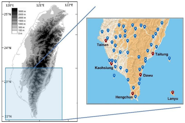
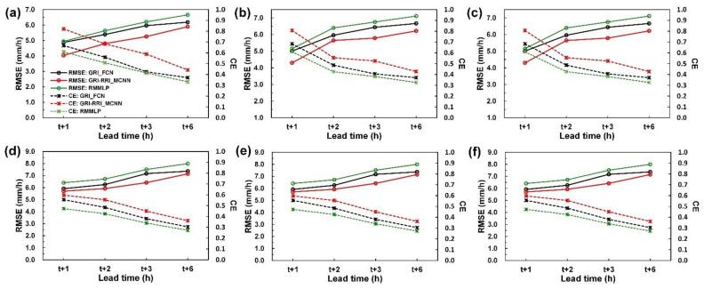
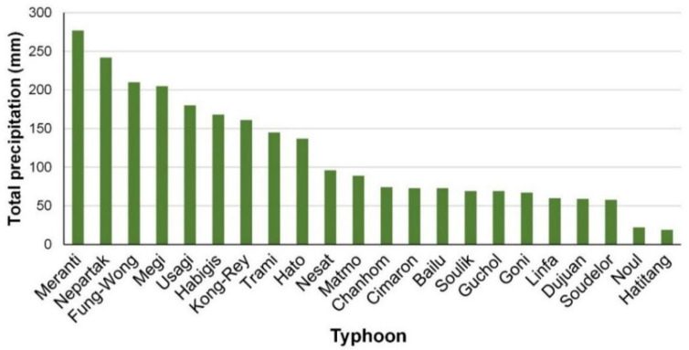
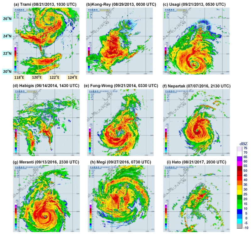
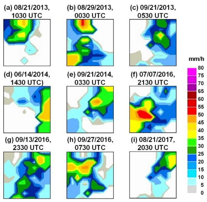
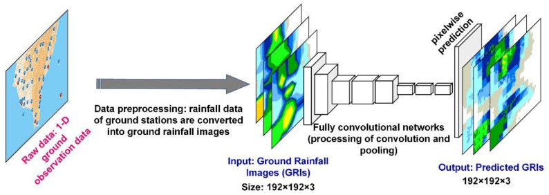
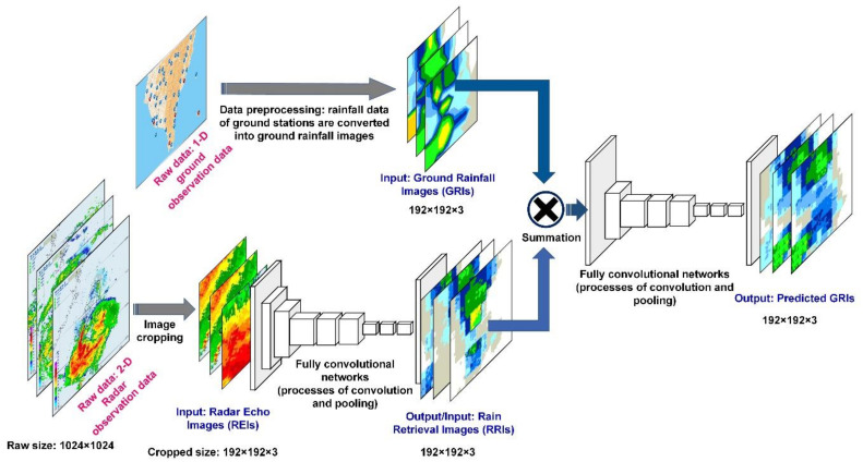
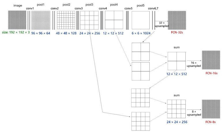
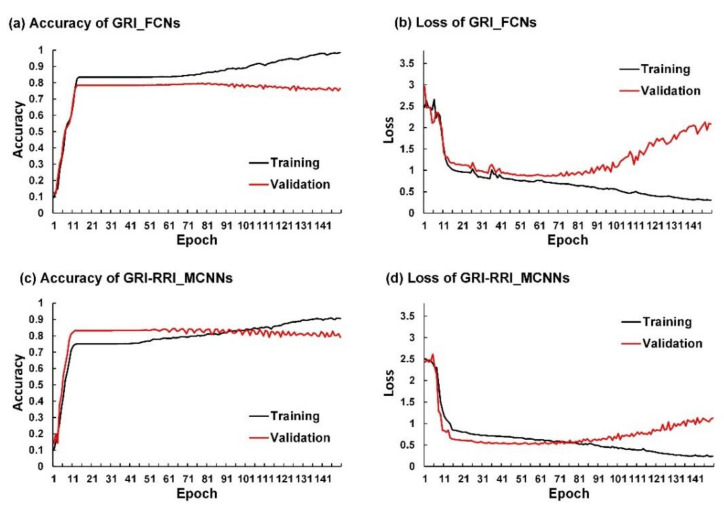
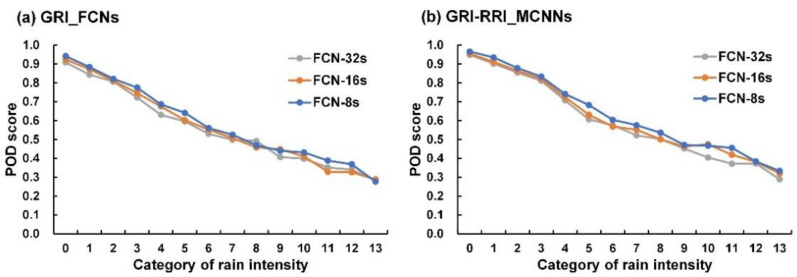
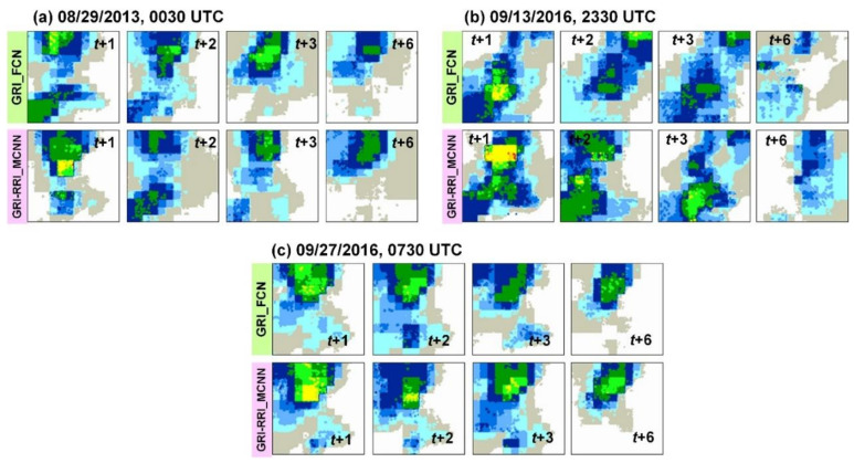
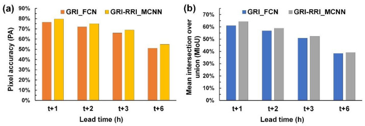
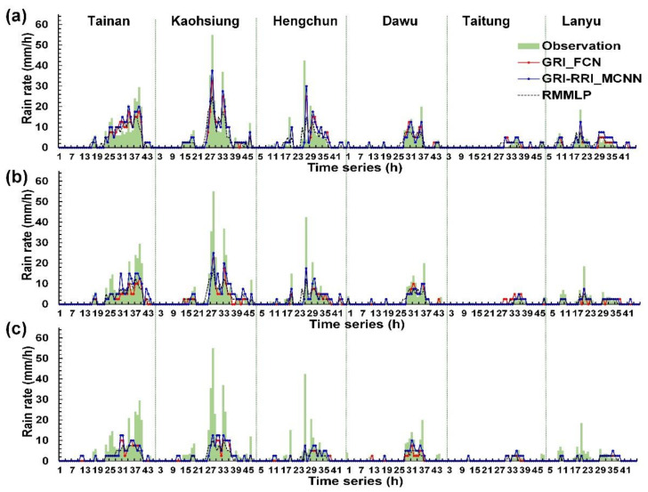
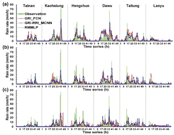
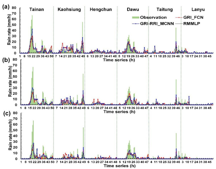
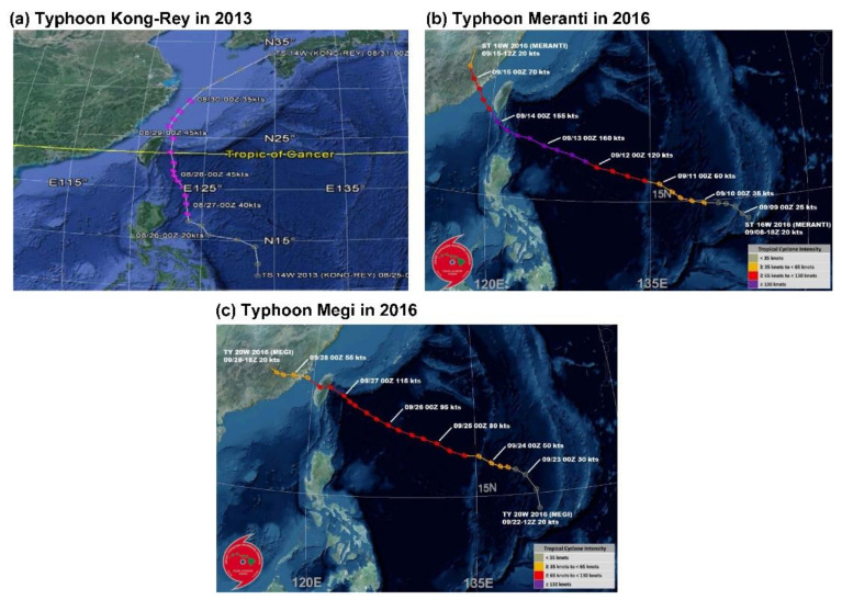
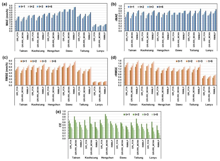
Taiwan is located at the edge of the northwestern Pacific Ocean and within a typhoon zone. After typhoons are generated, strong winds and heavy rains come to Taiwan and cause major natural disasters. This study employed fully convolutional networks (FCNs) to establish a forecast model for predicting the hourly rainfall data during the arrival of a typhoon. An FCN is an advanced technology that can be used to perform the deep learning of image recognition through semantic segmentation. FCNs deepen the neural net layers and perform upsampling on the feature map of the final convolution layer. This process enables FCN models to restore the size of the output results to that of the raw input image. In this manner, the classification of each raw pixel becomes feasible. The study data were radar echo images and ground station rainfall information for typhoon periods during 2013-2019 in southern Taiwan. Two model cases were designed. The ground rainfall image-based FCN (GRI_FCN) involved the use of the ground rain images to directly forecast the ground rainfall. The GRI combined with rain retrieval image-based modular convolutional neural network (GRI-RRI_MCNN) involved the use of radar echo images to determine the ground rainfall before the prediction of future ground rainfall. Moreover, the RMMLP, a conventional multilayer perceptron neural network, was used to a benchmark model. Forecast horizons varying from 1 to 6 h were evaluated. The results revealed that the GRI-RRI_MCNN model enabled a complete understanding of the future rainfall variation in southern Taiwan during typhoons and effectively improved the accuracy of rainfall forecasting during typhoons.

摘要

台湾位于西北太平洋边缘,处于台风带内。台风生成后,狂风暴雨会袭击台湾,造成重大自然灾害。本研究采用全卷积网络(FCN)建立台风来临时每小时降雨量的预测模型。FCN 是一种先进的技术,可以通过语义分割来实现图像识别的深度学习。FCN 加深神经网络的层数,并对最后卷积层的特征图进行上采样。这一过程使 FCN 模型能够将输出结果的大小恢复到原始输入图像的大小。这样,就可以对每个原始像素进行分类。本研究的数据是台湾南部 2013-2019 年台风期间的雷达回波图像和地面站降雨信息。设计了两个模型案例。基于地面降雨图像的 FCN(GRI_FCN)使用地面降雨图像直接预测地面降雨。GRI 与基于降雨反演图像的模块化卷积神经网络(GRI-RRI_MCNN)相结合,在预测未来地面降雨之前,使用雷达回波图像来确定地面降雨。此外,还使用传统的多层感知机神经网络 RMMLP 作为基准模型。评估了从 1 到 6 小时的预测时窗。结果表明,GRI-RRI_MCNN 模型能够全面了解台风期间台湾南部未来的降雨变化,有效提高了台风期间的降雨预测精度。

https://cdn.ncbi.nlm.nih.gov/pmc/blobs/4350/8235076/dbb760f139f7/sensors-21-04200-g017.jpg
https://cdn.ncbi.nlm.nih.gov/pmc/blobs/4350/8235076/26f286734a4d/sensors-21-04200-g001.jpg
https://cdn.ncbi.nlm.nih.gov/pmc/blobs/4350/8235076/740b007682da/sensors-21-04200-g002.jpg
https://cdn.ncbi.nlm.nih.gov/pmc/blobs/4350/8235076/049ad37d26ee/sensors-21-04200-g003.jpg
https://cdn.ncbi.nlm.nih.gov/pmc/blobs/4350/8235076/3de7627d1093/sensors-21-04200-g004.jpg
https://cdn.ncbi.nlm.nih.gov/pmc/blobs/4350/8235076/bbd8b71b5665/sensors-21-04200-g005.jpg
https://cdn.ncbi.nlm.nih.gov/pmc/blobs/4350/8235076/c0bfe352f535/sensors-21-04200-g006.jpg
https://cdn.ncbi.nlm.nih.gov/pmc/blobs/4350/8235076/916e49df92b0/sensors-21-04200-g007.jpg
https://cdn.ncbi.nlm.nih.gov/pmc/blobs/4350/8235076/5d02933336d9/sensors-21-04200-g008.jpg
https://cdn.ncbi.nlm.nih.gov/pmc/blobs/4350/8235076/e01e7b388efa/sensors-21-04200-g009.jpg
https://cdn.ncbi.nlm.nih.gov/pmc/blobs/4350/8235076/67b1015291dc/sensors-21-04200-g010.jpg
https://cdn.ncbi.nlm.nih.gov/pmc/blobs/4350/8235076/463213dcb461/sensors-21-04200-g011.jpg
https://cdn.ncbi.nlm.nih.gov/pmc/blobs/4350/8235076/de90edfa2a0c/sensors-21-04200-g012.jpg
https://cdn.ncbi.nlm.nih.gov/pmc/blobs/4350/8235076/3b3aa42f3af4/sensors-21-04200-g013.jpg
https://cdn.ncbi.nlm.nih.gov/pmc/blobs/4350/8235076/6acee66ddddc/sensors-21-04200-g014.jpg
https://cdn.ncbi.nlm.nih.gov/pmc/blobs/4350/8235076/2bcc5eae5312/sensors-21-04200-g015.jpg
https://cdn.ncbi.nlm.nih.gov/pmc/blobs/4350/8235076/d51a7cd7a9a0/sensors-21-04200-g016.jpg
https://cdn.ncbi.nlm.nih.gov/pmc/blobs/4350/8235076/dbb760f139f7/sensors-21-04200-g017.jpg

相似文献

1
Modular Neural Networks with Fully Convolutional Networks for Typhoon-Induced Short-Term Rainfall Predictions.基于全卷积网络的模块化神经网络在台风短期降雨预测中的应用。
Sensors (Basel). 2021 Jun 18;21(12):4200. doi: 10.3390/s21124200.
2
Forecasting of Typhoon-Induced Wind-Wave by Using Convolutional Deep Learning on Fused Data of Remote Sensing and Ground Measurements.利用遥感和地面测量融合数据的卷积深度学习预测台风引起的风浪。
Sensors (Basel). 2021 Aug 2;21(15):5234. doi: 10.3390/s21155234.
3
Real-Time Rainfall Forecasts Based on Radar Reflectivity during Typhoons: Case Study in Southeastern Taiwan.基于台风期间雷达反射率的实时降雨预报:以台湾东南部为例。
Sensors (Basel). 2021 Feb 18;21(4):1421. doi: 10.3390/s21041421.
4
Measuring the effects of typhoon trajectories on dengue outbreaks in tropical regions of Taiwan: 1998-2019.测量台风轨迹对台湾热带地区登革热疫情爆发的影响:1998-2019 年。
Int J Biometeorol. 2023 Aug;67(8):1311-1322. doi: 10.1007/s00484-023-02498-0. Epub 2023 Jun 2.
5
A time series image prediction method combining a CNN and LSTM and its application in typhoon track prediction.一种结合卷积神经网络(CNN)和长短期记忆网络(LSTM)的时间序列图像预测方法及其在台风路径预测中的应用。
Math Biosci Eng. 2022 Aug 22;19(12):12260-12278. doi: 10.3934/mbe.2022571.
6
Typhoon disaster emergency forecasting method based on big data.基于大数据的台风灾害应急预测方法
PLoS One. 2024 Apr 25;19(4):e0299530. doi: 10.1371/journal.pone.0299530. eCollection 2024.
7
Joint Risk of Rainfall and Storm Surges during Typhoons in a Coastal City of Haidian Island, China.中国沿海城市海岛县降雨和风暴潮的联合风险
Int J Environ Res Public Health. 2018 Jun 30;15(7):1377. doi: 10.3390/ijerph15071377.
8
Automatic liver segmentation by integrating fully convolutional networks into active contour models.基于全卷积网络的主动轮廓模型自动肝脏分割
Med Phys. 2019 Oct;46(10):4455-4469. doi: 10.1002/mp.13735. Epub 2019 Aug 16.
9
Complex networks for tracking extreme rainfall during typhoons.用于追踪台风期间极端降雨的复杂网络。
Chaos. 2018 Jul;28(7):075301. doi: 10.1063/1.5004480.
10
A segmentation method combining probability map and boundary based on multiple fully convolutional networks and repetitive training.一种基于多个全卷积网络和重复训练的概率图和边界相结合的分割方法。
Phys Med Biol. 2019 Sep 11;64(18):185003. doi: 10.1088/1361-6560/ab0a90.

引用本文的文献

1
Forecasting of Typhoon-Induced Wind-Wave by Using Convolutional Deep Learning on Fused Data of Remote Sensing and Ground Measurements.利用遥感和地面测量融合数据的卷积深度学习预测台风引起的风浪。
Sensors (Basel). 2021 Aug 2;21(15):5234. doi: 10.3390/s21155234.

本文引用的文献

1
Real-Time Rainfall Forecasts Based on Radar Reflectivity during Typhoons: Case Study in Southeastern Taiwan.基于台风期间雷达反射率的实时降雨预报:以台湾东南部为例。
Sensors (Basel). 2021 Feb 18;21(4):1421. doi: 10.3390/s21041421.
2
Deep Learning-Based Real-Time Multiple-Object Detection and Tracking from Aerial Imagery via a Flying Robot with GPU-Based Embedded Devices.基于深度学习的通过配备基于GPU的嵌入式设备的飞行机器人从航空图像中进行实时多目标检测与跟踪
Sensors (Basel). 2019 Jul 31;19(15):3371. doi: 10.3390/s19153371.
3
Object Detection With Deep Learning: A Review.
基于深度学习的目标检测研究综述。
IEEE Trans Neural Netw Learn Syst. 2019 Nov;30(11):3212-3232. doi: 10.1109/TNNLS.2018.2876865. Epub 2019 Jan 28.