Centre for Polar Observation and Modelling, School of Earth and Environment, University of Leeds, Leeds, UK.
Lancaster Environment Centre, Lancaster University, Lancaster, UK.
Nat Commun. 2021 Nov 1;12(1):6069. doi: 10.1038/s41467-021-26229-4.
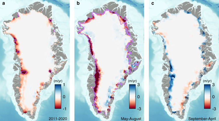
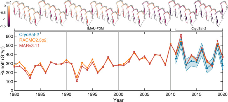
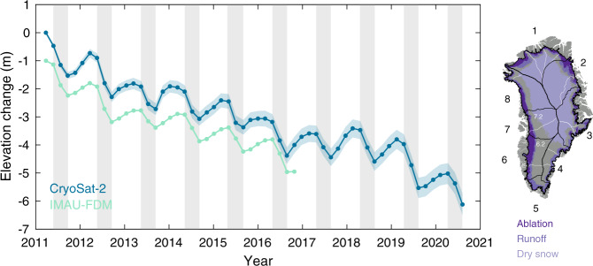
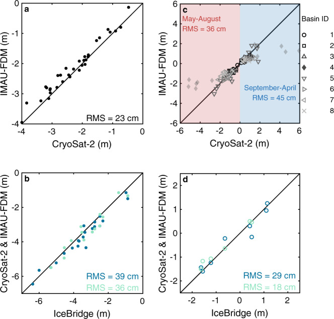
Runoff from the Greenland Ice Sheet has increased over recent decades affecting global sea level, regional ocean circulation, and coastal marine ecosystems, and it now accounts for most of the contemporary mass imbalance. Estimates of runoff are typically derived from regional climate models because satellite records have been limited to assessments of melting extent. Here, we use CryoSat-2 satellite altimetry to produce direct measurements of Greenland's runoff variability, based on seasonal changes in the ice sheet's surface elevation. Between 2011 and 2020, Greenland's ablation zone thinned on average by 1.4 ± 0.4 m each summer and thickened by 0.9 ± 0.4 m each winter. By adjusting for the steady-state divergence of ice, we estimate that runoff was 357 ± 58 Gt/yr on average - in close agreement with regional climate model simulations (root mean square difference of 47 to 60 Gt/yr). As well as being 21 % higher between 2011 and 2020 than over the preceding three decades, runoff is now also 60 % more variable from year-to-year as a consequence of large-scale fluctuations in atmospheric circulation. Because this variability is not captured in global climate model simulations, our satellite record of runoff should help to refine them and improve confidence in their projections.
近几十年来,来自格陵兰冰原的径流量不断增加,影响了全球海平面、区域海洋环流和沿海海洋生态系统,目前它占当前大部分质量不平衡的原因。径流量的估计通常来自区域气候模型,因为卫星记录仅限于对融化范围的评估。在这里,我们使用 CryoSat-2 卫星测高数据来制作格陵兰岛径流量变化的直接测量,这是基于冰盖表面高程的季节性变化。在 2011 年至 2020 年期间,格陵兰岛的消融区平均每个夏季变薄 1.4±0.4 米,每个冬季增厚 0.9±0.4 米。通过调整冰的稳态发散,我们估计平均每年的径流量为 357±58 Gt/yr,与区域气候模型模拟非常吻合(均方根差为 47 至 60 Gt/yr)。与过去三十年相比,2011 年至 2020 年期间的径流量增加了 21%,而且由于大气环流的大规模波动,每年的径流量变化也增加了 60%。由于全球气候模型模拟中没有捕捉到这种可变性,我们的卫星径流量记录应该有助于改进这些模型,并提高对其预测的信心。