• 文献检索
  • 文档翻译
  • 深度研究
  • 学术资讯
  • Suppr Zotero 插件Zotero 插件
  • 邀请有礼
  • 套餐&价格
  • 历史记录
应用&插件
Suppr Zotero 插件Zotero 插件浏览器插件Mac 客户端Windows 客户端微信小程序
定价
高级版会员购买积分包购买API积分包
服务
文献检索文档翻译深度研究API 文档MCP 服务
关于我们
关于 Suppr公司介绍联系我们用户协议隐私条款
关注我们

Suppr 超能文献

核心技术专利:CN118964589B侵权必究
粤ICP备2023148730 号-1Suppr @ 2026

文献检索

告别复杂PubMed语法,用中文像聊天一样搜索,搜遍4000万医学文献。AI智能推荐,让科研检索更轻松。

立即免费搜索

文件翻译

保留排版,准确专业,支持PDF/Word/PPT等文件格式,支持 12+语言互译。

免费翻译文档

深度研究

AI帮你快速写综述,25分钟生成高质量综述,智能提取关键信息,辅助科研写作。

立即免费体验

利用智能手机传感器和众包技术实现高效的表面地图创建和跟踪。

An Efficient Surface Map Creation and Tracking Using Smartphone Sensors and Crowdsourcing.

机构信息

Department of Electrical & Computer Engineering, North South University, Dhaka 1229, Bangladesh.

出版信息

Sensors (Basel). 2021 Oct 20;21(21):6969. doi: 10.3390/s21216969.

DOI:10.3390/s21216969
PMID:34770276
原文链接:https://pmc.ncbi.nlm.nih.gov/articles/PMC8587749/
Abstract

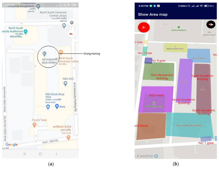
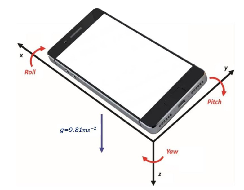
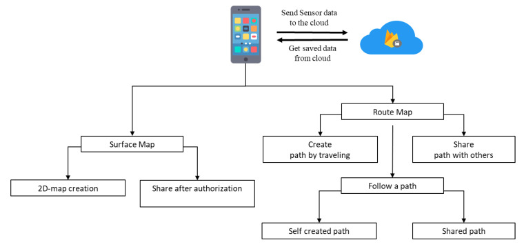
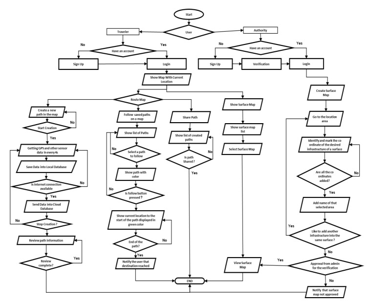
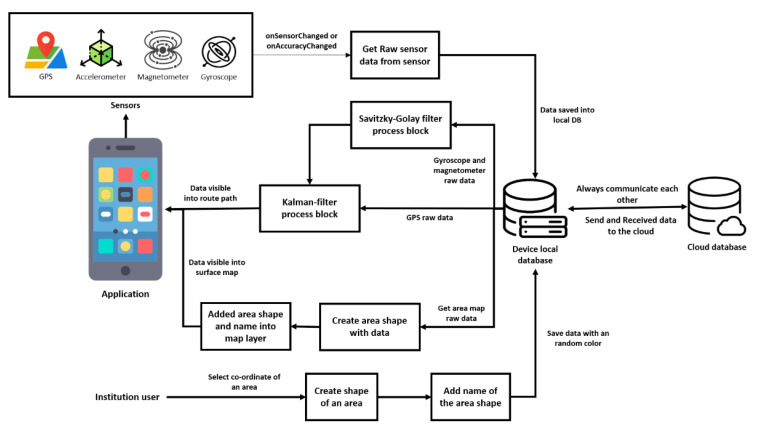
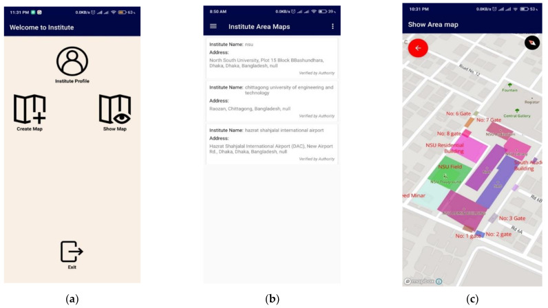
Like Smart Home and Smart Devices, Smart Navigation has become necessary to travel through the congestion of the structure of either building or in the wild. The advancement in smartphone technology and incorporation of many different precise sensors have made the smartphone a unique choice for developing practical navigation applications. Many have taken the initiative to address this by developing mobile-based solutions. Here, a cloud-based intelligent traveler assistant is proposed that exploits user-generated position and elevation data collected from ubiquitous smartphone devices equipped with Accelerometer, Gyroscope, Magnetometer, and GPS (Global Positioning System) sensors. The data can be collected by the pedestrians and the drivers, and are then automatically put into topological information. The platform and associated innovative application allow travelers to create a map of a route or an infrastructure with ease and to share the information for others to follow. The cloud-based solution that does not cost travelers anything allows them to create, access, and follow any maps online and offline. The proposed solution consumes little battery power and can be used with lowly configured resources. The ability to create unknown, unreached, or unrecognized rural/urban road maps, building structures, and the wild map with the help of volunteer traveler-generated data and to share these data with the greater community makes the presented solution unique and valuable. The proposed crowdsourcing method of knowing the unknown would be an excellent support for travelers.

摘要

像智能家居和智能设备一样,智能导航已经成为穿越建筑物或野外结构拥堵的必要手段。智能手机技术的进步和众多不同精确传感器的结合,使得智能手机成为开发实用导航应用的独特选择。许多人已经主动通过开发基于移动的解决方案来解决这个问题。在这里,提出了一种基于云的智能旅行者助手,它利用了从配备加速度计、陀螺仪、磁力计和 GPS(全球定位系统)传感器的普及智能手机设备收集的用户生成的位置和海拔数据。数据可以由行人和驾驶员收集,然后自动转换为拓扑信息。该平台和相关创新应用程序允许旅行者轻松创建路线或基础设施的地图,并共享信息供其他人遵循。基于云的解决方案不向旅行者收取任何费用,允许他们在线和离线创建、访问和遵循任何地图。所提出的解决方案消耗的电池电量很少,并且可以在低配置资源上使用。借助志愿者旅行者生成的数据创建未知、未到达或未被识别的农村/城市道路地图、建筑物结构和野外地图的能力,并将这些数据与更广泛的社区共享,使得所提出的解决方案具有独特性和价值。这种众包的未知知识方法将是旅行者的绝佳支持。

https://cdn.ncbi.nlm.nih.gov/pmc/blobs/1a95/8587749/84566a3f56fe/sensors-21-06969-g015.jpg
https://cdn.ncbi.nlm.nih.gov/pmc/blobs/1a95/8587749/67c49a8c169d/sensors-21-06969-g001.jpg
https://cdn.ncbi.nlm.nih.gov/pmc/blobs/1a95/8587749/28c83c9a7602/sensors-21-06969-g002.jpg
https://cdn.ncbi.nlm.nih.gov/pmc/blobs/1a95/8587749/f435fc33d3a3/sensors-21-06969-g003.jpg
https://cdn.ncbi.nlm.nih.gov/pmc/blobs/1a95/8587749/ece888d859e0/sensors-21-06969-g004.jpg
https://cdn.ncbi.nlm.nih.gov/pmc/blobs/1a95/8587749/4bb5a599efd5/sensors-21-06969-g005.jpg
https://cdn.ncbi.nlm.nih.gov/pmc/blobs/1a95/8587749/180b667f7acf/sensors-21-06969-g006.jpg
https://cdn.ncbi.nlm.nih.gov/pmc/blobs/1a95/8587749/748dd1be68dd/sensors-21-06969-g007.jpg
https://cdn.ncbi.nlm.nih.gov/pmc/blobs/1a95/8587749/6de751b50942/sensors-21-06969-g008.jpg
https://cdn.ncbi.nlm.nih.gov/pmc/blobs/1a95/8587749/bd1a0f4e7166/sensors-21-06969-g009.jpg
https://cdn.ncbi.nlm.nih.gov/pmc/blobs/1a95/8587749/dd44ad01ae89/sensors-21-06969-g010.jpg
https://cdn.ncbi.nlm.nih.gov/pmc/blobs/1a95/8587749/c3d7f4830369/sensors-21-06969-g011.jpg
https://cdn.ncbi.nlm.nih.gov/pmc/blobs/1a95/8587749/8625d39ec8a4/sensors-21-06969-g012.jpg
https://cdn.ncbi.nlm.nih.gov/pmc/blobs/1a95/8587749/8f34bb85c6f4/sensors-21-06969-g013.jpg
https://cdn.ncbi.nlm.nih.gov/pmc/blobs/1a95/8587749/ca0e18929957/sensors-21-06969-g014.jpg
https://cdn.ncbi.nlm.nih.gov/pmc/blobs/1a95/8587749/84566a3f56fe/sensors-21-06969-g015.jpg

相似文献

1
An Efficient Surface Map Creation and Tracking Using Smartphone Sensors and Crowdsourcing.利用智能手机传感器和众包技术实现高效的表面地图创建和跟踪。
Sensors (Basel). 2021 Oct 20;21(21):6969. doi: 10.3390/s21216969.
2
Citizen Sensors for SHM: Towards a Crowdsourcing Platform.用于结构健康监测的公民传感器:迈向众包平台。
Sensors (Basel). 2015 Jun 19;15(6):14591-614. doi: 10.3390/s150614591.
3
Semantic VPS for Smartphone Localization in Challenging Urban Environments.用于挑战性城市环境中智能手机定位的语义 VPS。
Sensors (Basel). 2021 Sep 13;21(18):6137. doi: 10.3390/s21186137.
4
An Improved Map-Matching Technique Based on the Fréchet Distance Approach for Pedestrian Navigation Services.一种基于弗雷歇距离法的改进型地图匹配技术,用于行人导航服务。
Sensors (Basel). 2016 Oct 22;16(10):1768. doi: 10.3390/s16101768.
5
An intelligent indoor positioning system based on pedestrian directional signage object detection: a case study of Taipei Main Station.基于行人方向指示牌目标检测的智能室内定位系统:以台北车站为例。
Math Biosci Eng. 2019 Oct 8;17(1):266-285. doi: 10.3934/mbe.2020015.
6
Towards the Crowdsourcing of Massive Smartphone Assisted-GPS Sensor Ground Observations for the Production of Digital Terrain Models.迈向通过众包大规模智能手机辅助全球定位系统(GPS)传感器地面观测数据来生成数字地形模型。
Sensors (Basel). 2018 Mar 17;18(3):898. doi: 10.3390/s18030898.
7
Using a Clustering Method to Detect Spatial Events in a Smartphone-Based Crowd-Sourced Database for Environmental Noise Assessment.利用聚类方法检测基于智能手机的人群源环境噪声评估数据库中的空间事件。
Sensors (Basel). 2022 Nov 15;22(22):8832. doi: 10.3390/s22228832.
8
Wearable Urban Mobility Assistive Device for Visually Impaired Pedestrians Using a Smartphone and a Tactile-Foot Interface.使用智能手机和触觉足垫的视障行人可穿戴式城市移动辅助设备。
Sensors (Basel). 2021 Aug 4;21(16):5274. doi: 10.3390/s21165274.
9
iSignDB: A database for smartphone signature biometrics.iSignDB:一个用于智能手机签名生物识别的数据库。
Data Brief. 2020 Nov 28;33:106597. doi: 10.1016/j.dib.2020.106597. eCollection 2020 Dec.
10
A hybrid smartphone indoor positioning solution for mobile LBS.一种用于移动 LBS 的混合智能手机室内定位解决方案。
Sensors (Basel). 2012 Dec 12;12(12):17208-33. doi: 10.3390/s121217208.

本文引用的文献

1
Constructing an Indoor Floor Plan Using Crowdsourcing Based on Magnetic Fingerprinting.基于磁指纹的众包室内平面图构建
Sensors (Basel). 2017 Nov 20;17(11):2678. doi: 10.3390/s17112678.
2
A Robust Crowdsourcing-Based Indoor Localization System.一种基于众包的稳健室内定位系统。
Sensors (Basel). 2017 Apr 14;17(4):864. doi: 10.3390/s17040864.
3
A Kalman filter implementation for precision improvement in low-cost GPS positioning of tractors.一种卡尔曼滤波器在拖拉机低成本 GPS 定位精度改进中的实现。
Sensors (Basel). 2013 Nov 8;13(11):15307-23. doi: 10.3390/s131115307.