School of Geography and Environmental Science, University of Southampton, Southampton, UK.
School of Public Health, University of Ghana, Accra, Ghana.
Sci Rep. 2022 Mar 8;12(1):3701. doi: 10.1038/s41598-022-07720-4.
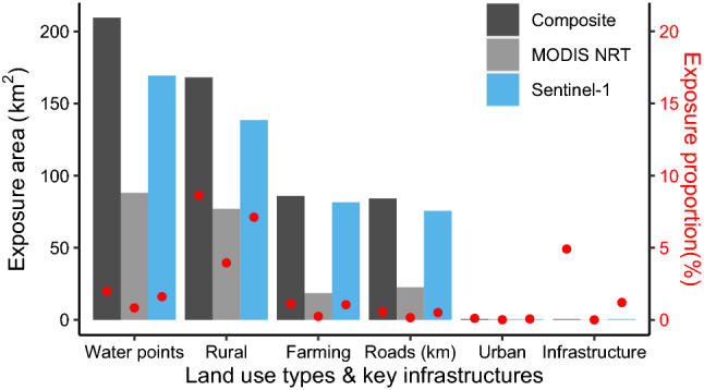
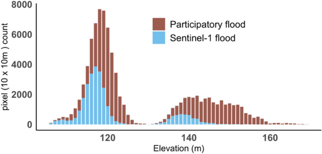
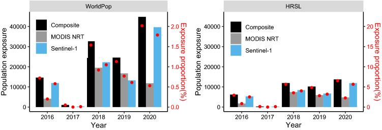
Accurate information on flood extent and exposure is critical for disaster management in data-scarce, vulnerable regions, such as Sub-Saharan Africa (SSA). However, uncertainties in flood extent affect flood exposure estimates. This study developed a framework to examine the spatiotemporal pattern of floods and to assess flood exposure through utilization of satellite images, ground-based participatory mapping of flood extent, and socio-economic data. Drawing on a case study in the White Volta basin in Western Africa, our results showed that synergetic use of multi-temporal radar and optical satellite data improved flood mapping accuracy (77% overall agreement compared with participatory mapping outputs), in comparison with existing global flood datasets (43% overall agreement for the moderate-resolution imaging spectroradiometer (MODIS) Near Real-Time (NRT) Global Flood Product). Increases in flood extent were observed according to our classified product, as well as two existing global flood products. Similarly, increased flood exposure was also observed, however its estimation remains highly uncertain and sensitive to the input dataset used. Population exposure varied greatly depending on the population dataset used, while the greatest farmland and infrastructure exposure was estimated using a composite flood map derived from three products, with lower exposure estimated from each flood product individually. The study shows that there is considerable scope to develop an accurate flood mapping system in SSA and thereby improve flood exposure assessment and develop mitigation and intervention plans.
在数据匮乏、脆弱的地区,如撒哈拉以南非洲(SSA),准确的洪水范围和暴露信息对于灾害管理至关重要。然而,洪水范围的不确定性会影响洪水暴露估计。本研究开发了一个框架,通过利用卫星图像、基于地面的洪水范围参与式绘图以及社会经济数据,来研究洪水的时空模式,并评估洪水暴露情况。本研究以西非白沃尔特河流域为例,结果表明,多时间雷达和光学卫星数据的协同使用提高了洪水绘图的准确性(与参与式绘图结果相比,总体一致性为 77%),与现有的全球洪水数据集(中分辨率成像光谱仪(MODIS)近实时(NRT)全球洪水产品的总体一致性为 43%)相比。根据我们的分类产品以及两个现有的全球洪水产品,洪水范围都有所增加。同样,也观察到洪水暴露的增加,但对其估计仍然高度不确定,并且对输入数据集非常敏感。人口暴露程度因使用的人口数据集而异,而最大的农田和基础设施暴露程度是根据三个产品的合成洪水图来估计的,而每个洪水产品单独估计的暴露程度较低。该研究表明,在 SSA 开发准确的洪水绘图系统以改进洪水暴露评估和制定缓解和干预计划有很大的空间。