• 文献检索
  • 文档翻译
  • 深度研究
  • 学术资讯
  • Suppr Zotero 插件Zotero 插件
  • 邀请有礼
  • 套餐&价格
  • 历史记录
应用&插件
Suppr Zotero 插件Zotero 插件浏览器插件Mac 客户端Windows 客户端微信小程序
定价
高级版会员购买积分包购买API积分包
服务
文献检索文档翻译深度研究API 文档MCP 服务
关于我们
关于 Suppr公司介绍联系我们用户协议隐私条款
关注我们

Suppr 超能文献

核心技术专利:CN118964589B侵权必究
粤ICP备2023148730 号-1Suppr @ 2026

文献检索

告别复杂PubMed语法,用中文像聊天一样搜索,搜遍4000万医学文献。AI智能推荐,让科研检索更轻松。

立即免费搜索

文件翻译

保留排版,准确专业,支持PDF/Word/PPT等文件格式,支持 12+语言互译。

免费翻译文档

深度研究

AI帮你快速写综述,25分钟生成高质量综述,智能提取关键信息,辅助科研写作。

立即免费体验

俄罗斯色楞格河三角洲地表水的分布驱动因素及范围

Drivers and extent of surface water occurrence in the Selenga River Delta, Russia.

作者信息

Aminjafari Saeid, Brown Ian, Chalov Sergey, Simard Marc, Lane Charles R, Jarsjö Jerker, Darvishi Mehdi, Jaramillo Fernando

机构信息

Department of Physical Geography and Bolin Centre for Climate Research, Stockholm University, Stockholm SE-106 91, Sweden.

Faculty of Geography, Lomonosov Moscow State University, Moscow 119991, Russia.

出版信息

J Hydrol Reg Stud. 2021 Dec;38:1-18. doi: 10.1016/j.ejrh.2021.100945.

DOI:10.1016/j.ejrh.2021.100945
PMID:35529522
原文链接:https://pmc.ncbi.nlm.nih.gov/articles/PMC9067400/
Abstract

STUDY REGION

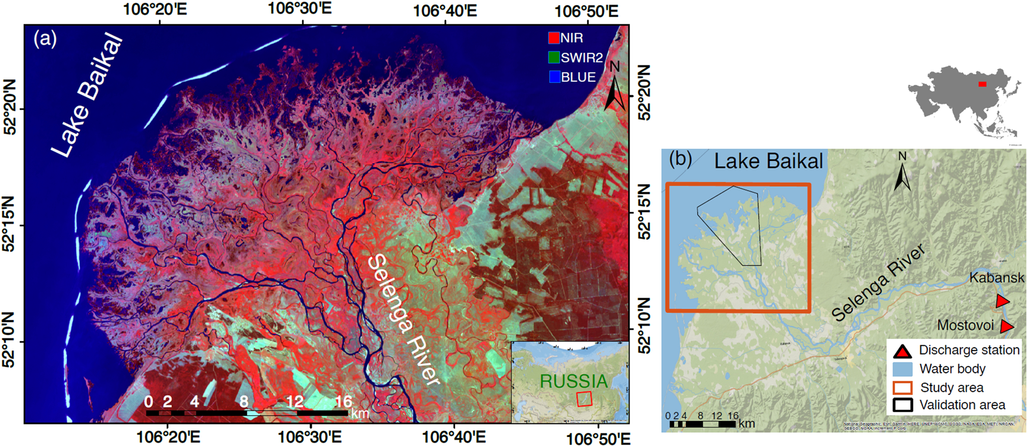
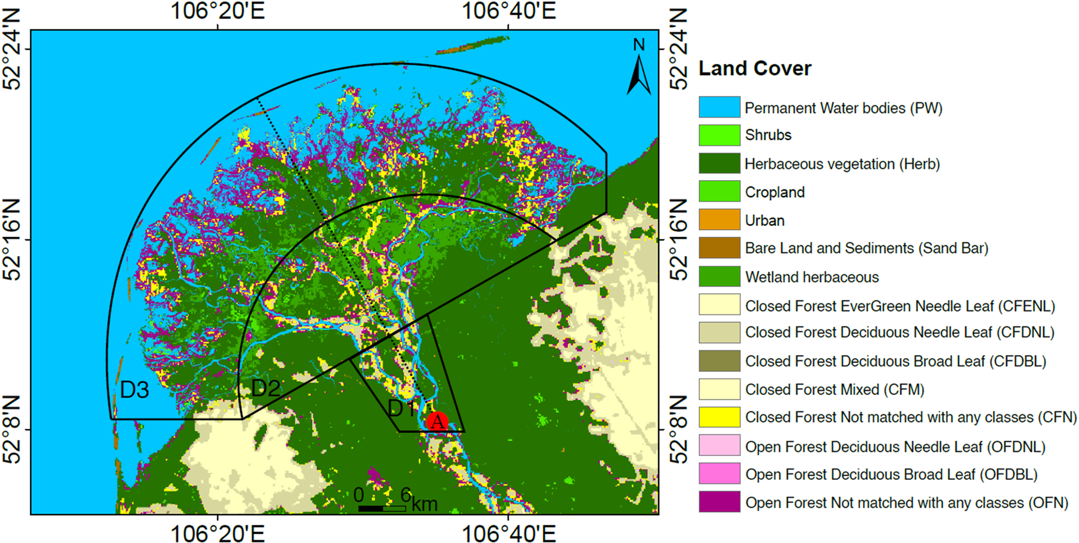
Selenga River Delta (SRD), Russia.

STUDY FOCUS

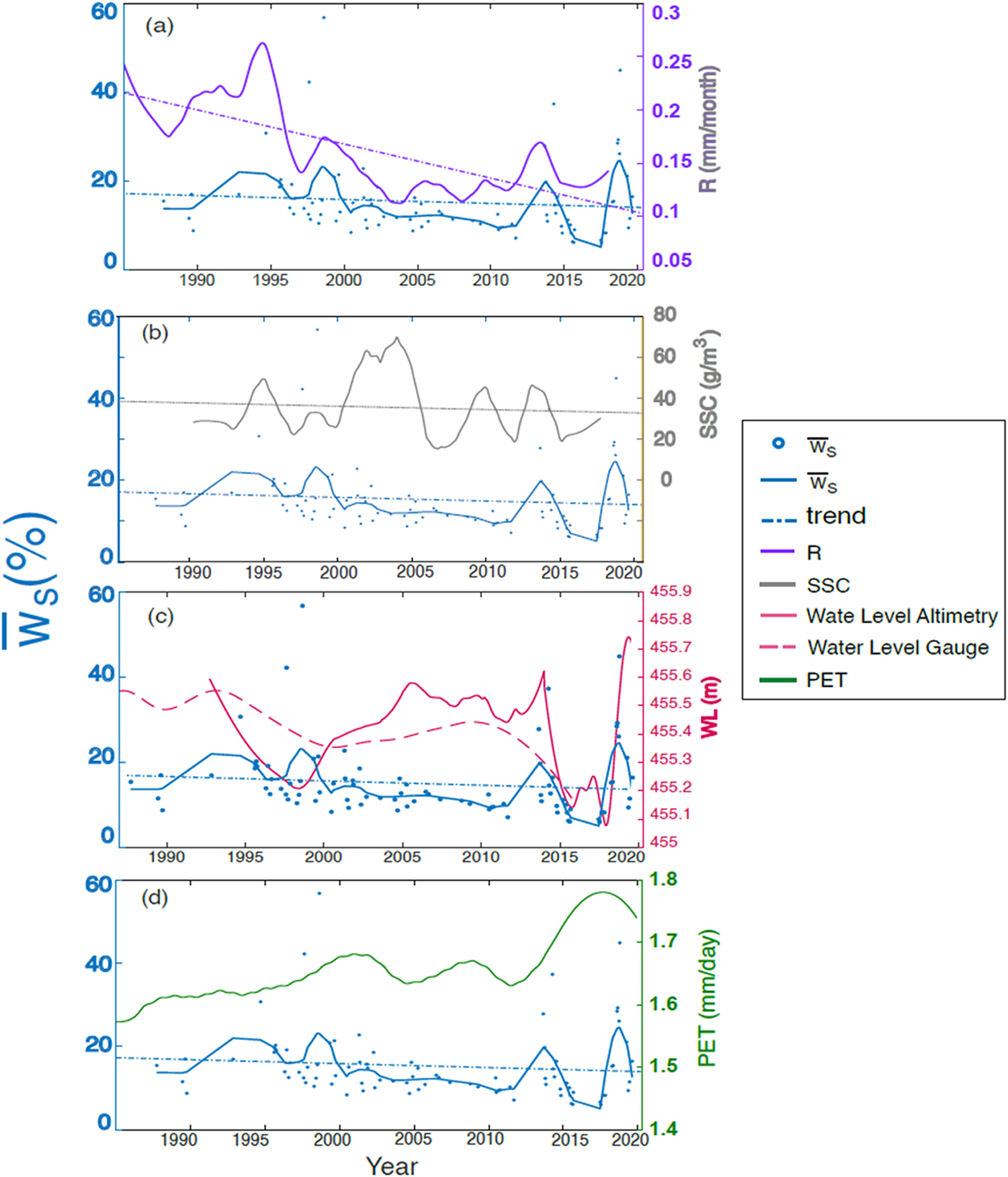
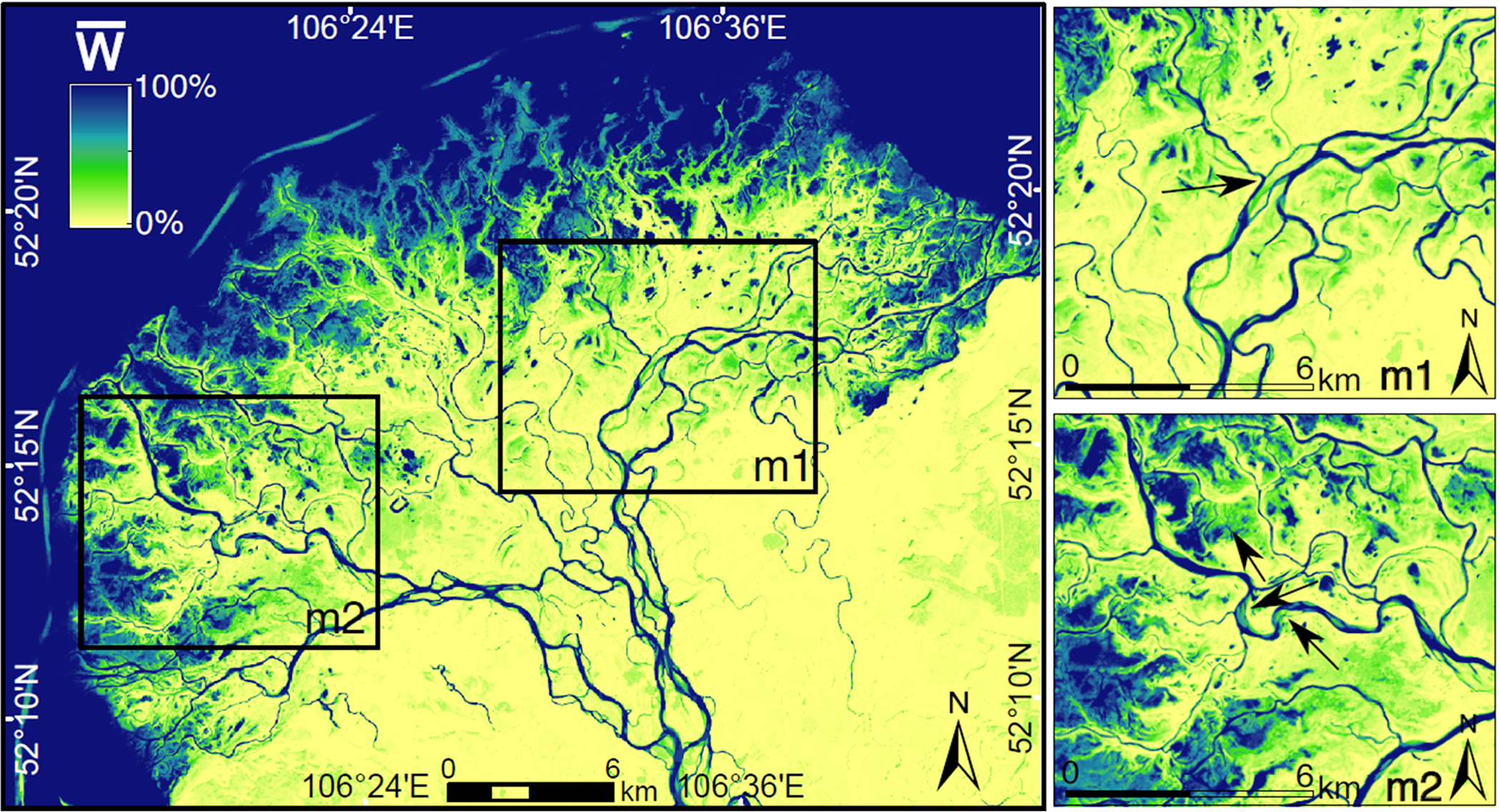
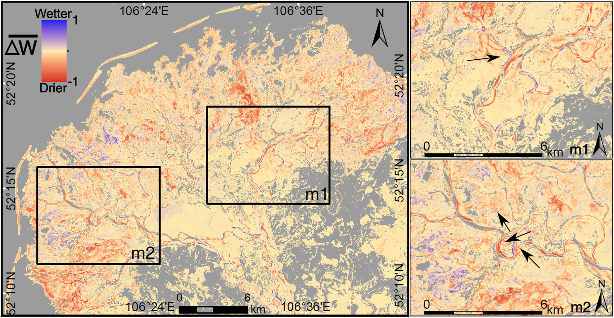
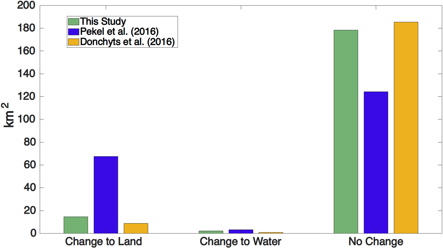
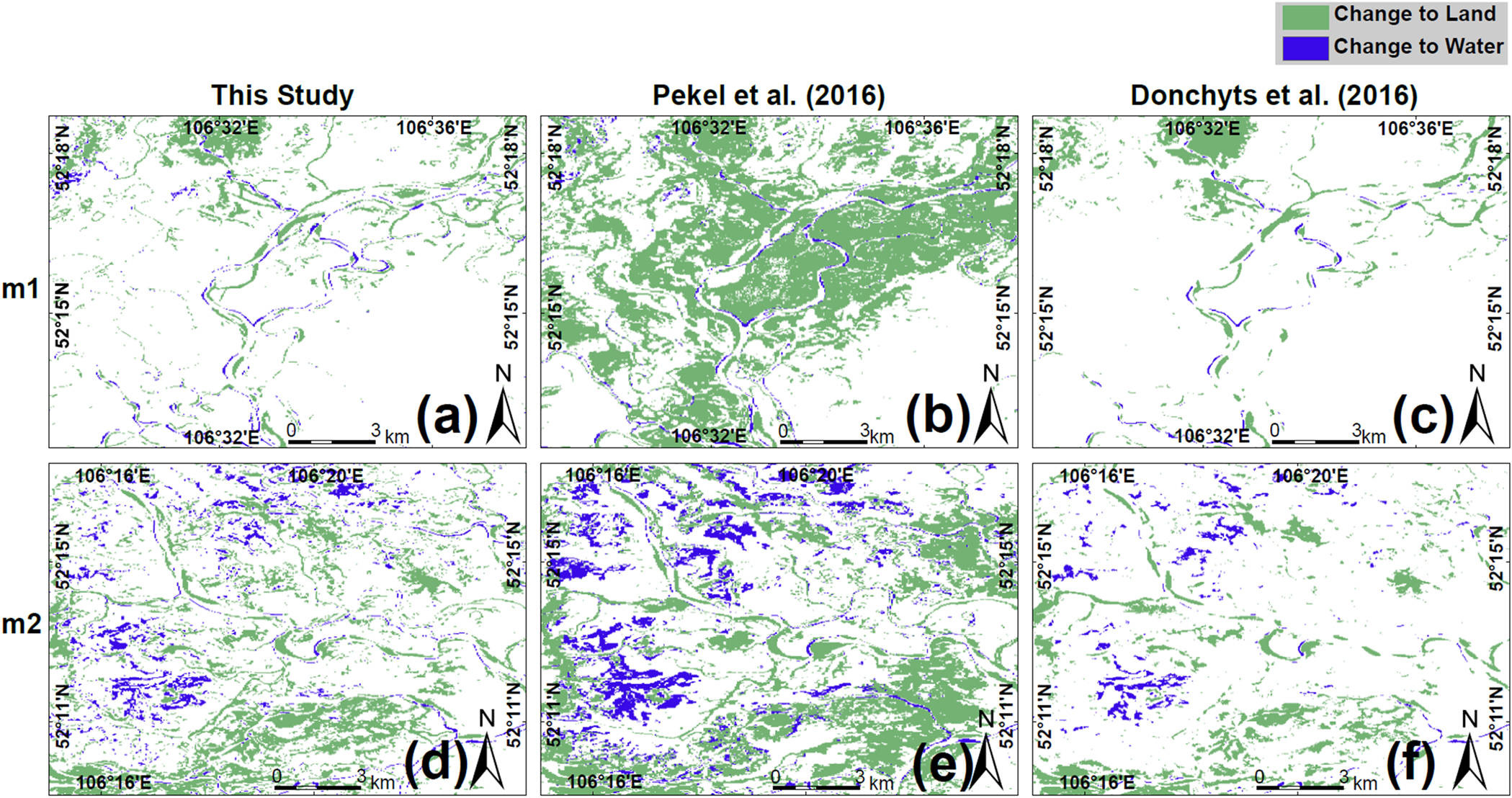
How is water occurrence changing in the SRD, and what are the hydroclimatic drivers behind these changes? The presence of water on the surface in river deltas is governed by land use, geomorphology, and the flux of water to and from the Delta. We trained an accurate image classification of the Landsat satellite imagery during the last 33 years to quantify surface water occurrence and its changes in the SRD. After comparing our estimations with global-scale datasets, we determined the hydrological drivers of these changes.

NEW HYDROLOGICAL INSIGHTS FOR THE REGION

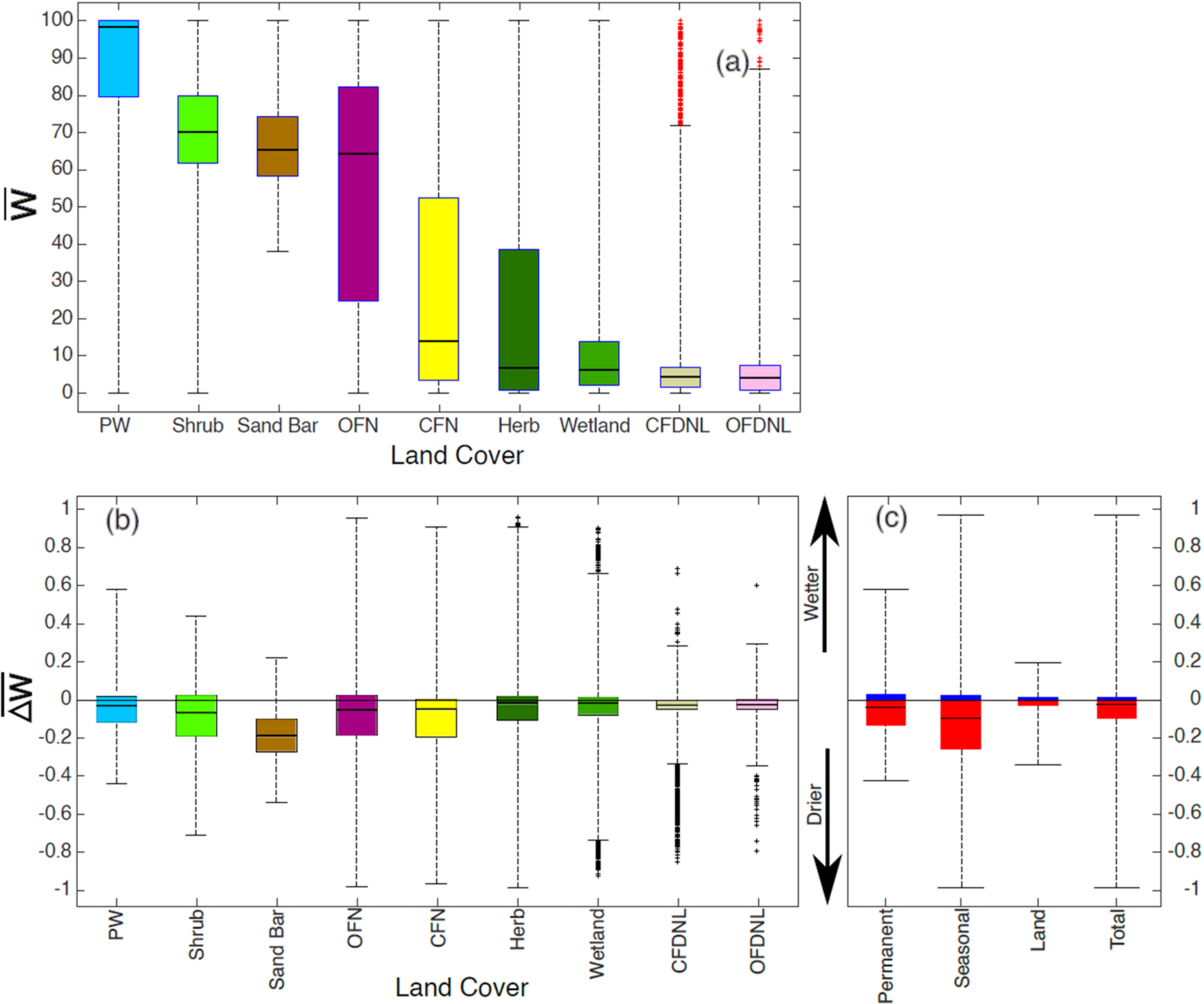
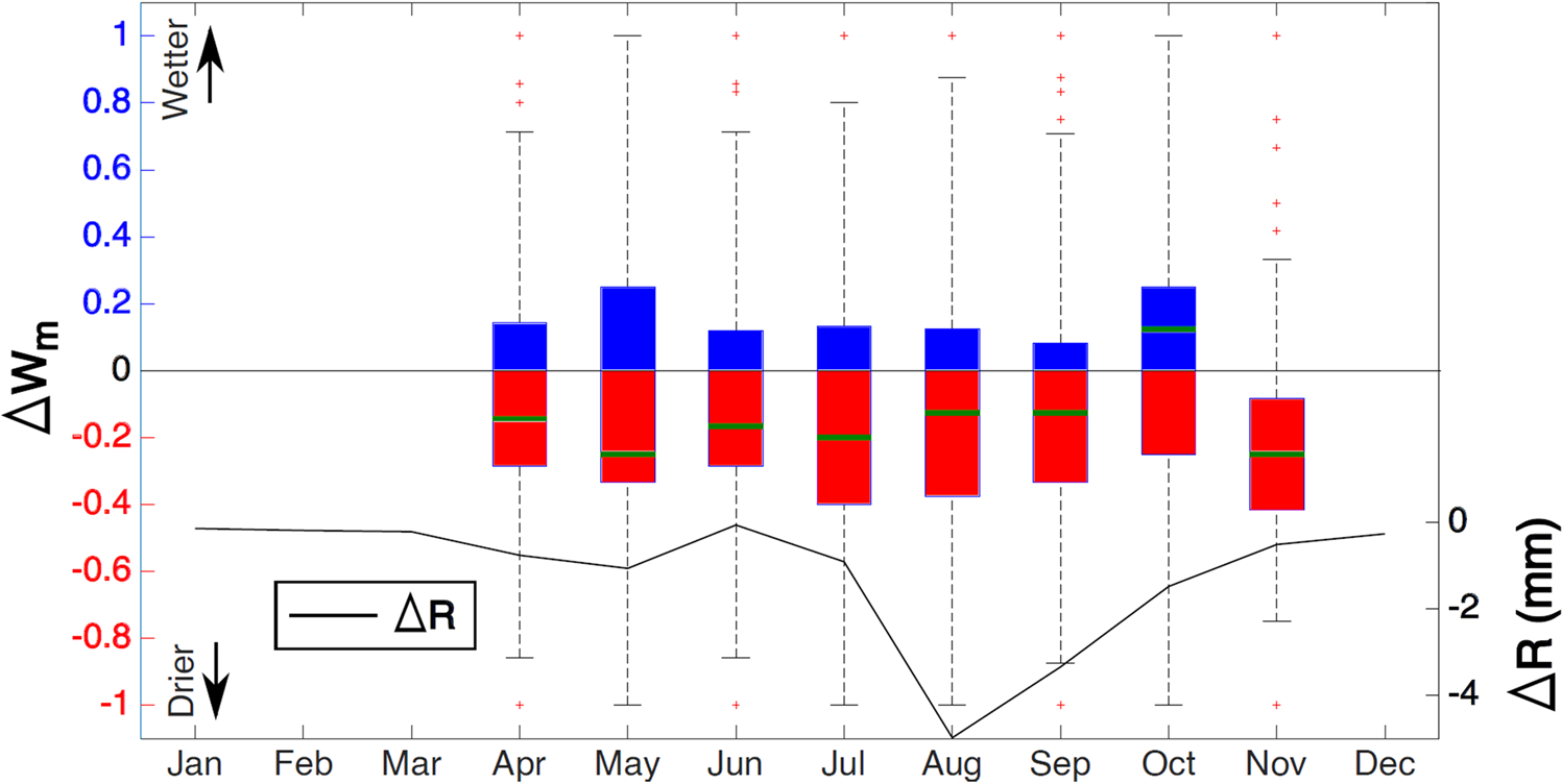
We find mild decreases in water occurrence in 51% of the SRD's surface area from 1987-2002 to 2003-2020. Water occurrence in the most affected areas decreased by 20% and in the most water-gaining areas increased by 10%. We find a significant relationship between water occurrence and runoff (R = 0.56) that does not exist between water occurrence and suspended sediment concentration (SSC), Lake Baikal's water level, and potential evapotranspiration. The time series of water occurrence follows the peaks in the runoff but not its long-term trend. However, the extremes in SSC do not influence surface water occurrence (R < 0.1), although their long-term trends are similar. Contrary to expected, we find that the Delta has a relatively stable long-term water availability for the time being.

摘要

研究区域

俄罗斯色楞格河三角洲(SRD)。

研究重点

色楞格河三角洲的地表水状况如何变化,以及这些变化背后的水文气候驱动因素是什么?河三角洲地表水体的存在受土地利用、地貌以及进出三角洲的水流通量控制。我们对过去33年的陆地卫星图像进行了精确的图像分类,以量化色楞格河三角洲地表水状况及其变化。在将我们的估算结果与全球尺度数据集进行比较之后,我们确定了这些变化的水文驱动因素。

该区域新的水文见解

我们发现,从1987 - 2002年到2003 - 2020年,色楞格河三角洲51%的表面积的地表水状况略有下降。受影响最严重地区的地表水状况下降了20%,而地表水增加最多的地区则增加了10%。我们发现地表水状况与径流之间存在显著关系(R = 0.56),而地表水状况与悬浮泥沙浓度(SSC)、贝加尔湖水位和潜在蒸散之间不存在这种关系。地表水状况的时间序列跟随径流的峰值,但不跟随其长期趋势。然而,尽管悬浮泥沙浓度的长期趋势相似,但其极值并不影响地表水状况(R < 0.1)。与预期相反,我们发现目前三角洲的长期可用水量相对稳定。

https://cdn.ncbi.nlm.nih.gov/pmc/blobs/6a02/9067400/2fd65a43f569/nihms-1751663-f0010.jpg
https://cdn.ncbi.nlm.nih.gov/pmc/blobs/6a02/9067400/703c0c0205b3/nihms-1751663-f0001.jpg
https://cdn.ncbi.nlm.nih.gov/pmc/blobs/6a02/9067400/c50837042adb/nihms-1751663-f0002.jpg
https://cdn.ncbi.nlm.nih.gov/pmc/blobs/6a02/9067400/b11ac2b26dc8/nihms-1751663-f0003.jpg
https://cdn.ncbi.nlm.nih.gov/pmc/blobs/6a02/9067400/460900344426/nihms-1751663-f0004.jpg
https://cdn.ncbi.nlm.nih.gov/pmc/blobs/6a02/9067400/16aaadd1bc74/nihms-1751663-f0005.jpg
https://cdn.ncbi.nlm.nih.gov/pmc/blobs/6a02/9067400/d9f49307d152/nihms-1751663-f0006.jpg
https://cdn.ncbi.nlm.nih.gov/pmc/blobs/6a02/9067400/56ce87936d11/nihms-1751663-f0007.jpg
https://cdn.ncbi.nlm.nih.gov/pmc/blobs/6a02/9067400/2dace98bbddd/nihms-1751663-f0008.jpg
https://cdn.ncbi.nlm.nih.gov/pmc/blobs/6a02/9067400/0121043f6767/nihms-1751663-f0009.jpg
https://cdn.ncbi.nlm.nih.gov/pmc/blobs/6a02/9067400/2fd65a43f569/nihms-1751663-f0010.jpg

相似文献

1
Drivers and extent of surface water occurrence in the Selenga River Delta, Russia.俄罗斯色楞格河三角洲地表水的分布驱动因素及范围
J Hydrol Reg Stud. 2021 Dec;38:1-18. doi: 10.1016/j.ejrh.2021.100945.
2
Earthquake, floods and changing land use history: A 200-year overview of environmental changes in Selenga River basin as indicated by n-alkanes and related proxies in sediments from shallow lakes.地震、洪水和土地利用历史变化:通过浅湖沉积物中 n-烷烃和相关示踪物指示的色楞格河流域 200 年来的环境变化概述。
Sci Total Environ. 2023 May 15;873:162245. doi: 10.1016/j.scitotenv.2023.162245. Epub 2023 Feb 18.
3
Mercury loading within the Selenga River basin and Lake Baikal, Siberia.西伯利亚色楞格河流域和贝加尔湖的汞负荷。
Environ Pollut. 2020 Apr;259:113814. doi: 10.1016/j.envpol.2019.113814. Epub 2019 Dec 16.
4
Inter-comparison of water balance components of river basins draining into selected delta districts of Eastern India.对比流入印度东部选定三角洲地区的河流流域的水量平衡组成部分。
Sci Total Environ. 2019 Mar 1;654:1258-1269. doi: 10.1016/j.scitotenv.2018.11.162. Epub 2018 Nov 12.
5
Sustained increase in suspended sediments near global river deltas over the past two decades.在过去二十年里,全球河流三角洲附近悬浮沉积物持续增加。
Nat Commun. 2024 Apr 18;15(1):3319. doi: 10.1038/s41467-024-47598-6.
6
Large-scale monitoring and assessment of metal contamination in surface water of the Selenga River Basin (2007-2009).色楞格河流域地表水金属污染的大规模监测与评估(2007 - 2009年)
Environ Sci Pollut Res Int. 2015 Feb;22(4):2856-67. doi: 10.1007/s11356-014-3564-6. Epub 2014 Sep 14.
7
Lake sediment records of persistent organic pollutants and polycyclic aromatic hydrocarbons in southern Siberia mirror the changing fortunes of the Russian economy over the past 70 years.西伯利亚南部湖泊沉积物中持久性有机污染物和多环芳烃的记录反映了俄罗斯经济在过去 70 年中的兴衰变化。
Environ Pollut. 2018 Nov;242(Pt A):528-538. doi: 10.1016/j.envpol.2018.07.005. Epub 2018 Jul 3.
8
Analysis of Land Use/Cover Change and Driving Forces in the Selenga River Basin.分析色楞格河流域的土地利用/覆被变化及其驱动力。
Sensors (Basel). 2022 Jan 28;22(3):1041. doi: 10.3390/s22031041.
9
Assessing the long-term effects of land use changes on runoff patterns and food production in a large lake watershed with policy implications.评估土地利用变化对大型湖泊流域径流量模式和粮食生产的长期影响及其政策意义。
J Environ Manage. 2017 Dec 15;204(Pt 1):92-101. doi: 10.1016/j.jenvman.2017.08.043. Epub 2017 Aug 30.
10
[Decline of Gammarus lacustris Sars (Crustacea: Amphipoda) population in the delta of the Selenga River].[色楞格河三角洲湖泊钩虾(甲壳纲:端足目)种群数量的下降]
Izv Akad Nauk Ser Biol. 2014 Mar-Apr(2):176-84.

本文引用的文献

1
Future Hydroclimatic Impacts on Africa: Beyond the Paris Agreement.未来水文气候对非洲的影响:超越《巴黎协定》
Earths Future. 2019 Jul;7(7):748-761. doi: 10.1029/2019EF001169. Epub 2019 Jul 11.
2
Version 4 of the CRU TS monthly high-resolution gridded multivariate climate dataset.第四版 CRU TS 月高分辨率网格化多变量气候数据集。
Sci Data. 2020 Apr 3;7(1):109. doi: 10.1038/s41597-020-0453-3.
3
Preliminary analysis of the performance of the Landsat 8/OLI land surface reflectance product.陆地卫星8号/OLI地表反射率产品性能的初步分析
Remote Sens Environ. 2016 Apr 28;Volume 185(Iss 2):46-56. doi: 10.1016/j.rse.2016.04.008.
4
Global-scale human impact on delta morphology has led to net land area gain.全球范围内人类活动对三角洲形态的影响导致了净陆地面积的增加。
Nature. 2020 Jan;577(7791):514-518. doi: 10.1038/s41586-019-1905-9. Epub 2020 Jan 22.
5
Human activities have changed the shapes of river deltas.人类活动改变了河口三角洲的形状。
Nature. 2020 Jan;577(7791):473-474. doi: 10.1038/d41586-020-00047-y.
6
Decision-Tree, Rule-Based, and Random Forest Classification of High-Resolution Multispectral Imagery for Wetland Mapping and Inventory.用于湿地测绘与清查的高分辨率多光谱影像的决策树、基于规则和随机森林分类
Remote Sens (Basel). 2018;10(4):580. doi: 10.3390/rs10040580.
7
Global extent of rivers and streams.全球河流和溪流的范围。
Science. 2018 Aug 10;361(6402):585-588. doi: 10.1126/science.aat0636. Epub 2018 Jun 28.
8
A Review of Wetland Remote Sensing.湿地遥感研究综述。
Sensors (Basel). 2017 Apr 5;17(4):777. doi: 10.3390/s17040777.
9
High-resolution mapping of global surface water and its long-term changes.高分辨率绘制全球地表水及其长期变化图。
Nature. 2016 Dec 15;540(7633):418-422. doi: 10.1038/nature20584. Epub 2016 Dec 7.
10
Climate change: protect the world's deltas.气候变化:保护世界三角洲地区。
Nature. 2014 Dec 4;516(7529):31-3. doi: 10.1038/516031a.