• 文献检索
  • 文档翻译
  • 深度研究
  • 学术资讯
  • Suppr Zotero 插件Zotero 插件
  • 邀请有礼
  • 套餐&价格
  • 历史记录
应用&插件
Suppr Zotero 插件Zotero 插件浏览器插件Mac 客户端Windows 客户端微信小程序
定价
高级版会员购买积分包购买API积分包
服务
文献检索文档翻译深度研究API 文档MCP 服务
关于我们
关于 Suppr公司介绍联系我们用户协议隐私条款
关注我们

Suppr 超能文献

核心技术专利:CN118964589B侵权必究
粤ICP备2023148730 号-1Suppr @ 2026

文献检索

告别复杂PubMed语法,用中文像聊天一样搜索,搜遍4000万医学文献。AI智能推荐,让科研检索更轻松。

立即免费搜索

文件翻译

保留排版,准确专业,支持PDF/Word/PPT等文件格式,支持 12+语言互译。

免费翻译文档

深度研究

AI帮你快速写综述,25分钟生成高质量综述,智能提取关键信息,辅助科研写作。

立即免费体验

基于云的应用程序,用于访问卫星地球观测数据,以支持疟疾预警。

Cloud-based applications for accessing satellite Earth observations to support malaria early warning.

机构信息

Department of Geography and Environmental Sustainability, University of Oklahoma, Norman, OK, 73019, USA.

出版信息

Sci Data. 2022 May 16;9(1):208. doi: 10.1038/s41597-022-01337-y.

DOI:10.1038/s41597-022-01337-y
PMID:35577816
原文链接:https://pmc.ncbi.nlm.nih.gov/articles/PMC9110363/
Abstract

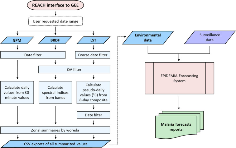
Malaria epidemics can be triggered by fluctuations in temperature and precipitation that influence vector mosquitoes and the malaria parasite. Identifying and monitoring environmental risk factors can thus provide early warning of future outbreaks. Satellite Earth observations provide relevant measurements, but obtaining these data requires substantial expertise, computational resources, and internet bandwidth. To support malaria forecasting in Ethiopia, we developed software for Retrieving Environmental Analytics for Climate and Health (REACH). REACH is a cloud-based application for accessing data on land surface temperature, spectral indices, and precipitation using the Google Earth Engine (GEE) platform. REACH can be implemented using the GEE code editor and JavaScript API, as a standalone web app, or as package with the Python API. Users provide a date range and data for 852 districts in Ethiopia are automatically summarized and downloaded as tables. REACH was successfully used in Ethiopia to support a pilot malaria early warning project in the Amhara region. The software can be extended to new locations and modified to access other environmental datasets through GEE.

摘要

疟疾疫情可能由影响病媒蚊子和疟原虫的温度和降水波动引发。因此,识别和监测环境风险因素可以为未来的疫情爆发提供预警。卫星地球观测提供了相关测量数据,但获取这些数据需要大量专业知识、计算资源和互联网带宽。为了支持埃塞俄比亚的疟疾预测,我们开发了用于检索气候和健康环境分析(REACH)的软件。REACH 是一个基于云的应用程序,用于使用谷歌地球引擎(GEE)平台访问陆地表面温度、光谱指数和降水数据。REACH 可以使用 GEE 代码编辑器和 JavaScript API 实现,也可以作为独立的网络应用程序或带有 Python API 的软件包实现。用户提供一个日期范围,埃塞俄比亚的 852 个地区的数据将自动汇总并下载为表格。REACH 在埃塞俄比亚成功用于支持阿姆哈拉地区的一个疟疾早期预警试点项目。该软件可以扩展到新的地点,并通过 GEE 进行修改以访问其他环境数据集。

https://cdn.ncbi.nlm.nih.gov/pmc/blobs/ff3a/9110363/cc0da3aad54f/41597_2022_1337_Fig7_HTML.jpg
https://cdn.ncbi.nlm.nih.gov/pmc/blobs/ff3a/9110363/0179e8a2e1ef/41597_2022_1337_Fig1_HTML.jpg
https://cdn.ncbi.nlm.nih.gov/pmc/blobs/ff3a/9110363/b58e833d3d0d/41597_2022_1337_Fig2_HTML.jpg
https://cdn.ncbi.nlm.nih.gov/pmc/blobs/ff3a/9110363/21519be11459/41597_2022_1337_Fig3_HTML.jpg
https://cdn.ncbi.nlm.nih.gov/pmc/blobs/ff3a/9110363/911bcc3fa7d8/41597_2022_1337_Fig4_HTML.jpg
https://cdn.ncbi.nlm.nih.gov/pmc/blobs/ff3a/9110363/87ca3117ee63/41597_2022_1337_Fig5_HTML.jpg
https://cdn.ncbi.nlm.nih.gov/pmc/blobs/ff3a/9110363/42c353ac51cb/41597_2022_1337_Fig6_HTML.jpg
https://cdn.ncbi.nlm.nih.gov/pmc/blobs/ff3a/9110363/cc0da3aad54f/41597_2022_1337_Fig7_HTML.jpg

相似文献

1
Cloud-based applications for accessing satellite Earth observations to support malaria early warning.基于云的应用程序,用于访问卫星地球观测数据,以支持疟疾预警。
Sci Data. 2022 May 16;9(1):208. doi: 10.1038/s41597-022-01337-y.
2
Integrating malaria surveillance with climate data for outbreak detection and forecasting: the EPIDEMIA system.将疟疾监测与气候数据相结合以进行疫情检测和预测:EPIDEMIA系统。
Malar J. 2017 Feb 23;16(1):89. doi: 10.1186/s12936-017-1735-x.
3
Mapping land cover change over continental Africa using Landsat and Google Earth Engine cloud computing.利用陆地卫星和谷歌地球引擎云计算绘制非洲大陆的土地覆盖变化图。
PLoS One. 2017 Sep 27;12(9):e0184926. doi: 10.1371/journal.pone.0184926. eCollection 2017.
4
Remote sensing-based time series models for malaria early warning in the highlands of Ethiopia.基于遥感的时间序列模型在埃塞俄比亚高地进行疟疾预警。
Malar J. 2012 May 14;11:165. doi: 10.1186/1475-2875-11-165.
5
Leveraging Google Earth Engine for Drought Assessment using Global Soil Moisture Data.利用谷歌地球引擎结合全球土壤湿度数据进行干旱评估。
Remote Sens (Basel). 2018;10(8). doi: 10.3390/rs10081265. Epub 2018 Aug 11.
6
Evaluation of Remotely Sensed and Interpolated Environmental Datasets for Vector-Borne Disease Monitoring Using In Situ Observations Over the Amhara Region, Ethiopia.利用埃塞俄比亚阿姆哈拉地区的实地观测评估遥感和插值环境数据集在虫媒传染病监测中的应用。
Sensors (Basel). 2020 Feb 28;20(5):1316. doi: 10.3390/s20051316.
7
A genetic algorithm for identifying spatially-varying environmental drivers in a malaria time series model.一种用于在疟疾时间序列模型中识别空间变化环境驱动因素的遗传算法。
Environ Model Softw. 2019 Sep;119:275-284. doi: 10.1016/j.envsoft.2019.06.010. Epub 2019 Jun 24.
8
Seasonal associations of climatic drivers and malaria in the highlands of Ethiopia.埃塞俄比亚高地气候驱动因素与疟疾的季节性关联
Parasit Vectors. 2015 Jun 24;8:339. doi: 10.1186/s13071-015-0954-7.
9
Spatial synchrony of malaria outbreaks in a highland region of Ethiopia.埃塞俄比亚高原地区疟疾疫情的时空同步性。
Trop Med Int Health. 2012 Oct;17(10):1192-201. doi: 10.1111/j.1365-3156.2012.03058.x. Epub 2012 Aug 5.
10
A Google Earth Engine-enabled Python approach for the identification of anthropogenic palaeo-landscape features.一种利用谷歌地球引擎的Python方法来识别古人类活动形成的景观特征。
Open Res Eur. 2021 Sep 3;1:22. doi: 10.12688/openreseurope.13135.2. eCollection 2021.

引用本文的文献

1
Spatiotemporal dataset of dengue influencing factors in Brazil based on geospatial big data cloud computing.基于地理空间大数据云计算的巴西登革热影响因素时空数据集
Sci Data. 2025 Apr 29;12(1):712. doi: 10.1038/s41597-025-05045-1.
2
Exploring the Relationship between Melioidosis Morbidity Rate and Local Environmental Indicators Using Remotely Sensed Data.利用遥感数据探索类鼻疽发病率与当地环境指标的关系。
Int J Environ Res Public Health. 2024 May 13;21(5):614. doi: 10.3390/ijerph21050614.
3
The Arbovirus Mapping and Prediction (ArboMAP) system for West Nile virus forecasting.

本文引用的文献

1
A genetic algorithm for identifying spatially-varying environmental drivers in a malaria time series model.一种用于在疟疾时间序列模型中识别空间变化环境驱动因素的遗传算法。
Environ Model Softw. 2019 Sep;119:275-284. doi: 10.1016/j.envsoft.2019.06.010. Epub 2019 Jun 24.
2
Satellite Observations and Malaria: New Opportunities for Research and Applications.卫星观测与疟疾:研究与应用的新机遇。
Trends Parasitol. 2021 Jun;37(6):525-537. doi: 10.1016/j.pt.2021.03.003. Epub 2021 Mar 25.
3
Identifying Environmental Risk Factors and Mapping the Distribution of West Nile Virus in an Endemic Region of North America.
用于西尼罗河病毒预测的虫媒病毒图谱与预测(ArboMAP)系统。
JAMIA Open. 2023 Dec 21;7(1):ooad110. doi: 10.1093/jamiaopen/ooad110. eCollection 2024 Apr.
4
Trend analysis of malaria in urban settings in Ethiopia from 2014 to 2019.2014 年至 2019 年埃塞俄比亚城市地区疟疾的趋势分析。
Malar J. 2023 Aug 14;22(1):235. doi: 10.1186/s12936-023-04656-6.
5
Forecasting Weekly Dengue Cases by Integrating Google Earth Engine-Based Risk Predictor Generation and Google Colab-Based Deep Learning Modeling in Fortaleza and the Federal District, Brazil.利用基于 Google Earth Engine 的风险预测模型生成和基于 Google Colab 的深度学习模型,对巴西福塔莱萨和联邦区的登革热进行每周病例预测。
Int J Environ Res Public Health. 2022 Oct 19;19(20):13555. doi: 10.3390/ijerph192013555.
识别北美一个流行地区的西尼罗河病毒环境风险因素并绘制其分布图。
Geohealth. 2018 Dec 27;2(12):395-409. doi: 10.1029/2018GH000161. eCollection 2018 Dec.
4
Evaluation of Remotely Sensed and Interpolated Environmental Datasets for Vector-Borne Disease Monitoring Using In Situ Observations Over the Amhara Region, Ethiopia.利用埃塞俄比亚阿姆哈拉地区的实地观测评估遥感和插值环境数据集在虫媒传染病监测中的应用。
Sensors (Basel). 2020 Feb 28;20(5):1316. doi: 10.3390/s20051316.
5
The effect of global change on mosquito-borne disease.全球变化对蚊媒传染病的影响。
Lancet Infect Dis. 2019 Sep;19(9):e302-e312. doi: 10.1016/S1473-3099(19)30161-6. Epub 2019 Jun 18.
6
Best practices in scaling digital health in low and middle income countries.在中低收入国家推广数字健康的最佳实践。
Global Health. 2018 Nov 3;14(1):103. doi: 10.1186/s12992-018-0424-z.
7
Projections of temperature-related excess mortality under climate change scenarios.气候变化情景下与温度相关的超额死亡率预测。
Lancet Planet Health. 2017 Dec;1(9):e360-e367. doi: 10.1016/S2542-5196(17)30156-0.
8
Global risk mapping for major diseases transmitted by Aedes aegypti and Aedes albopictus.全球登革热和白纹伊蚊传播主要疾病风险图
Int J Infect Dis. 2018 Feb;67:25-35. doi: 10.1016/j.ijid.2017.11.026. Epub 2017 Nov 28.
9
Heat Wave and Mortality: A Multicountry, Multicommunity Study.热浪与死亡率:一项多国多社区研究
Environ Health Perspect. 2017 Aug 10;125(8):087006. doi: 10.1289/EHP1026.
10
Integrating malaria surveillance with climate data for outbreak detection and forecasting: the EPIDEMIA system.将疟疾监测与气候数据相结合以进行疫情检测和预测:EPIDEMIA系统。
Malar J. 2017 Feb 23;16(1):89. doi: 10.1186/s12936-017-1735-x.