• 文献检索
  • 文档翻译
  • 深度研究
  • 学术资讯
  • Suppr Zotero 插件Zotero 插件
  • 邀请有礼
  • 套餐&价格
  • 历史记录
应用&插件
Suppr Zotero 插件Zotero 插件浏览器插件Mac 客户端Windows 客户端微信小程序
定价
高级版会员购买积分包购买API积分包
服务
文献检索文档翻译深度研究API 文档MCP 服务
关于我们
关于 Suppr公司介绍联系我们用户协议隐私条款
关注我们

Suppr 超能文献

核心技术专利:CN118964589B侵权必究
粤ICP备2023148730 号-1Suppr @ 2026

文献检索

告别复杂PubMed语法,用中文像聊天一样搜索,搜遍4000万医学文献。AI智能推荐,让科研检索更轻松。

立即免费搜索

文件翻译

保留排版,准确专业,支持PDF/Word/PPT等文件格式,支持 12+语言互译。

免费翻译文档

深度研究

AI帮你快速写综述,25分钟生成高质量综述,智能提取关键信息,辅助科研写作。

立即免费体验

卫星观测与疟疾:研究与应用的新机遇。

Satellite Observations and Malaria: New Opportunities for Research and Applications.

机构信息

Department of Geography and Environmental Sustainability, University of Oklahoma, Norman, OK, USA.

Department of Geography and Environmental Sustainability, University of Oklahoma, Norman, OK, USA.

出版信息

Trends Parasitol. 2021 Jun;37(6):525-537. doi: 10.1016/j.pt.2021.03.003. Epub 2021 Mar 25.

DOI:10.1016/j.pt.2021.03.003
PMID:33775559
原文链接:https://pmc.ncbi.nlm.nih.gov/articles/PMC8122067/
Abstract

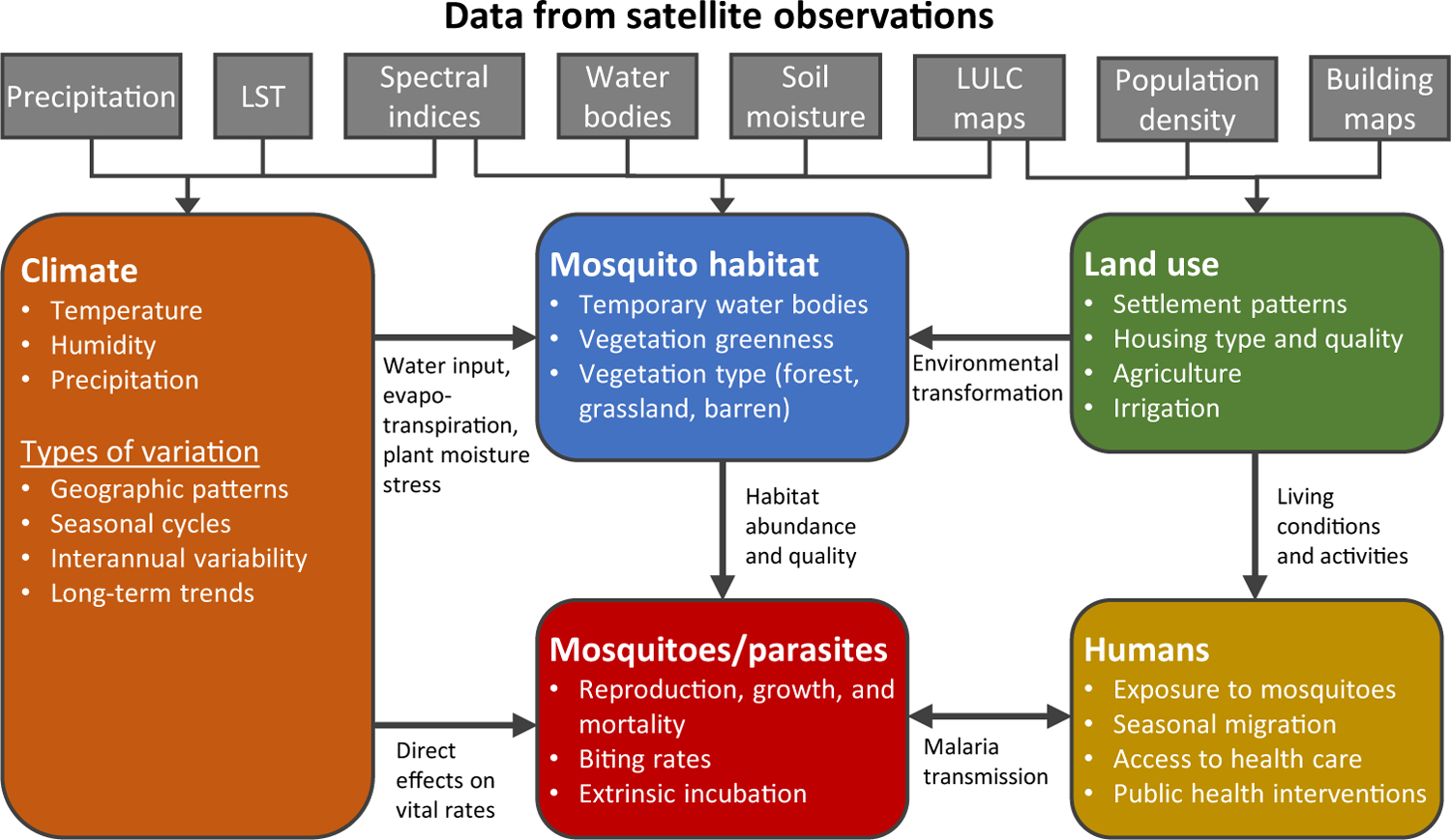
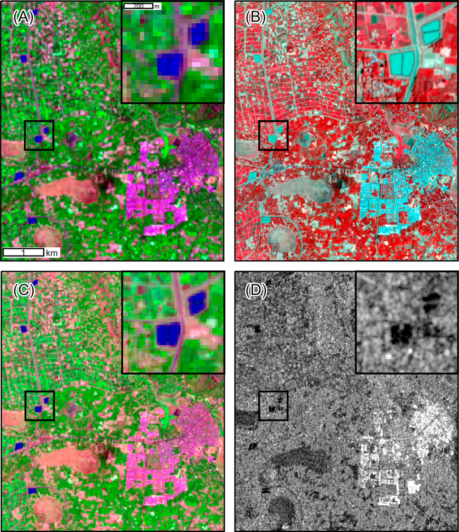
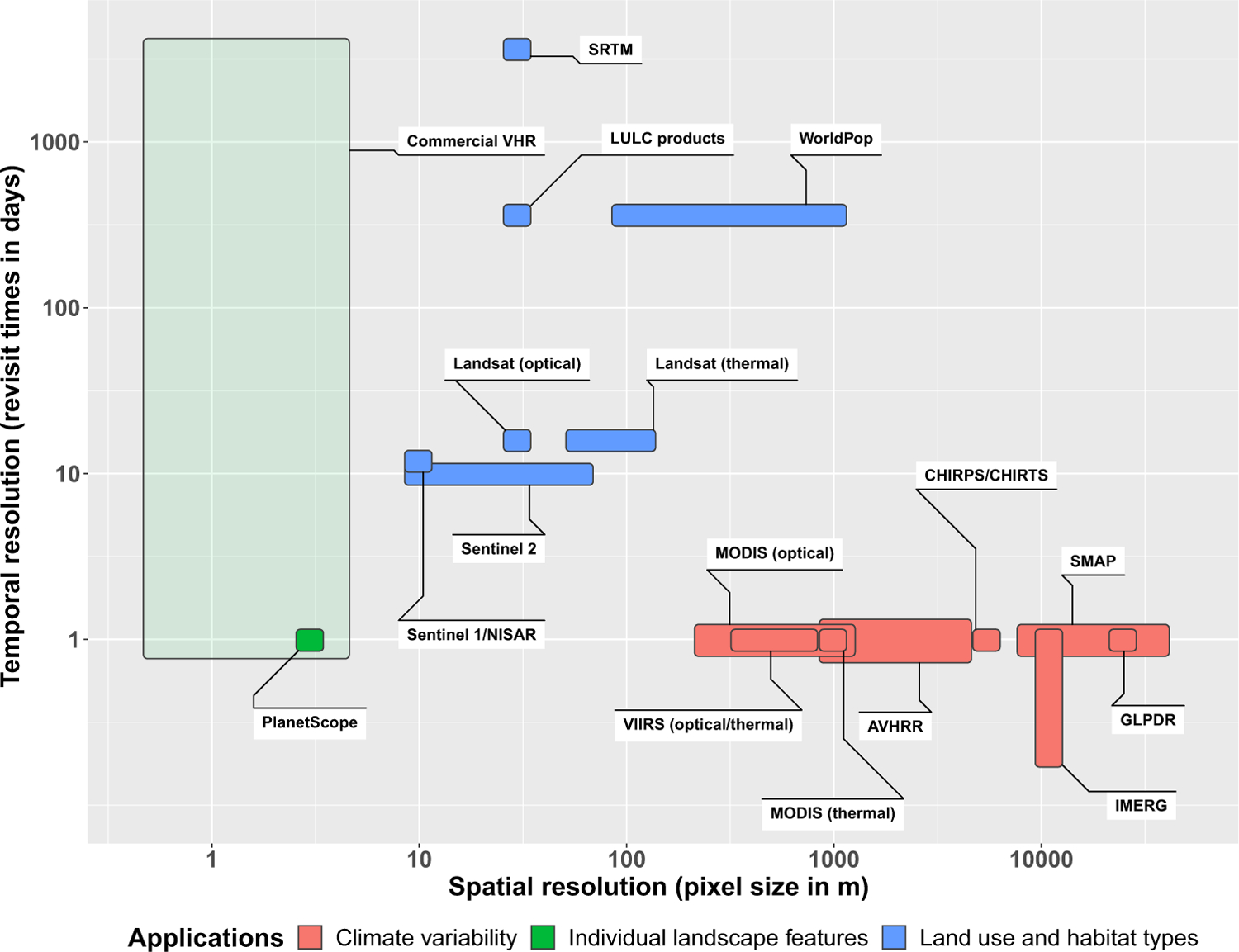
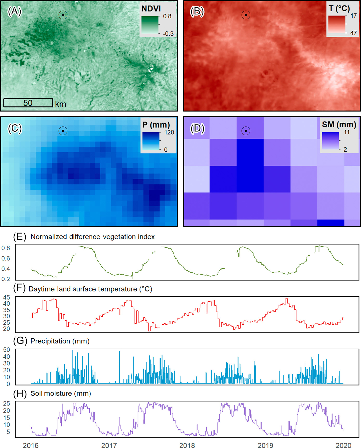
Satellite remote sensing provides a wealth of information about environmental factors that influence malaria transmission cycles and human populations at risk. Long-term observations facilitate analysis of climate-malaria relationships, and high-resolution data can be used to assess the effects of agriculture, urbanization, deforestation, and water management on malaria. New sources of very-high-resolution satellite imagery and synthetic aperture radar data will increase the precision and frequency of observations. Cloud computing platforms for remote sensing data combined with analysis-ready datasets and high-level data products have made satellite remote sensing more accessible to nonspecialists. Further collaboration between the malaria and remote sensing communities is needed to develop and implement useful geospatial data products that will support global efforts toward malaria control, elimination, and eradication.

摘要

卫星遥感提供了大量有关影响疟疾传播周期和处于危险中的人群的环境因素的信息。长期观测有助于分析气候与疟疾之间的关系,而高分辨率数据可用于评估农业、城市化、森林砍伐和水管理对疟疾的影响。非常高分辨率卫星图像和合成孔径雷达数据的新来源将提高观测的精度和频率。用于遥感数据的云计算平台与准备好进行分析的数据集和高级数据产品相结合,使卫星遥感更容易为非专业人员所使用。疟疾和遥感两个领域之间需要进一步合作,开发和实施有用的地理空间数据产品,以支持全球控制、消除和消灭疟疾的努力。

https://cdn.ncbi.nlm.nih.gov/pmc/blobs/8be4/8122067/8de0cdf55558/nihms-1683221-f0004.jpg
https://cdn.ncbi.nlm.nih.gov/pmc/blobs/8be4/8122067/bbfed4745aed/nihms-1683221-f0001.jpg
https://cdn.ncbi.nlm.nih.gov/pmc/blobs/8be4/8122067/cbedbfb69ee2/nihms-1683221-f0002.jpg
https://cdn.ncbi.nlm.nih.gov/pmc/blobs/8be4/8122067/2d422cf9b5c0/nihms-1683221-f0003.jpg
https://cdn.ncbi.nlm.nih.gov/pmc/blobs/8be4/8122067/8de0cdf55558/nihms-1683221-f0004.jpg

相似文献

1
Satellite Observations and Malaria: New Opportunities for Research and Applications.卫星观测与疟疾:研究与应用的新机遇。
Trends Parasitol. 2021 Jun;37(6):525-537. doi: 10.1016/j.pt.2021.03.003. Epub 2021 Mar 25.
2
Assessment and statistical modeling of the relationship between remotely sensed aerosol optical depth and PM2.5 in the eastern United States.美国东部地区遥感气溶胶光学厚度与PM2.5之间关系的评估及统计建模
Res Rep Health Eff Inst. 2012 May(167):5-83; discussion 85-91.
3
Evaluating the accuracy of satellite-based methods to estimate residential proximity to agricultural crops.评估基于卫星的方法估算居民与农作物之间的居住接近度的准确性。
J Expo Sci Environ Epidemiol. 2024 Mar;34(2):294-307. doi: 10.1038/s41370-022-00467-0. Epub 2022 Aug 24.
4
Monitoring spatio-temporal dynamics of urban and peri-urban land transitions using ensemble of remote sensing spectral indices-a case study of Chennai Metropolitan Area, India.利用遥感光谱指数集合监测城市和城郊土地转化的时空动态——以印度钦奈大都市区为例。
Environ Monit Assess. 2019 Dec 7;192(1):15. doi: 10.1007/s10661-019-7986-y.
5
A review of spatial technologies with applications for malaria transmission modelling and control in Africa.非洲疟疾传播建模与控制应用的空间技术综述。
Geospat Health. 2015 Nov 26;10(2):328. doi: 10.4081/gh.2015.328.
6
Multispectral analysis-ready satellite data for three East African mountain ecosystems.多光谱分析准备好的卫星数据,适用于三个东非山地生态系统。
Sci Data. 2024 May 9;11(1):473. doi: 10.1038/s41597-024-03283-3.
7
A review on drone-based harmful algae blooms monitoring.基于无人机的有害藻华监测研究综述。
Environ Monit Assess. 2019 Mar 9;191(4):211. doi: 10.1007/s10661-019-7365-8.
8
A study of the environmental determinants of malaria and schistosomiasis in the Philippines using Remote Sensing and Geographic Information Systems.利用遥感和地理信息系统对菲律宾疟疾和血吸虫病的环境决定因素进行的一项研究。
Parassitologia. 2005 Mar;47(1):105-14.
9
Remote sensing of tropical wetlands for malaria control in Chiapas, Mexico.墨西哥恰帕斯州用于疟疾防控的热带湿地遥感监测
Ecol Appl. 1994 Feb;4(1):81-90.
10
Application of satellite remote sensing in monitoring dissolved oxygen variabilities: A case study for coastal waters in Korea.卫星遥感在监测溶解氧变化中的应用:以韩国沿海海域为例。
Environ Int. 2020 Jan;134:105301. doi: 10.1016/j.envint.2019.105301. Epub 2019 Nov 16.

引用本文的文献

1
Environmental correlates of Aedes aegypti abundance in the West Valley region of San Bernardino County, California, USA, from 2017 to 2023: an ecological modeling study.2017年至2023年美国加利福尼亚州圣贝纳迪诺县西谷地区埃及伊蚊数量的环境相关因素:一项生态建模研究
Parasit Vectors. 2025 Aug 18;18(1):349. doi: 10.1186/s13071-025-06967-w.
2
Remote Sensing-Derived Environmental Variables to Estimate Transmission Risk and Predict Malaria Cases in Argentina: A Pre-Certification Study (1986-2005).利用遥感得出的环境变量评估阿根廷疟疾传播风险并预测疟疾病例:一项预认证研究(1986 - 2005年)
Pathogens. 2025 May 1;14(5):448. doi: 10.3390/pathogens14050448.
3

本文引用的文献

1
A genetic algorithm for identifying spatially-varying environmental drivers in a malaria time series model.一种用于在疟疾时间序列模型中识别空间变化环境驱动因素的遗传算法。
Environ Model Softw. 2019 Sep;119:275-284. doi: 10.1016/j.envsoft.2019.06.010. Epub 2019 Jun 24.
2
Malaria Transmission and Spillover across the Peru-Ecuador Border: A Spatiotemporal Analysis.疟疾在秘鲁-厄瓜多尔边境的传播和溢出:时空分析。
Int J Environ Res Public Health. 2020 Oct 13;17(20):7434. doi: 10.3390/ijerph17207434.
3
Incorporating hydrology into climate suitability models changes projections of malaria transmission in Africa.
Early warning systems, mobile technology, and cholera aversion: Evidence from rural Bangladesh.
早期预警系统、移动技术与霍乱预防:来自孟加拉国农村的证据
J Environ Econ Manage. 2024 May;125. doi: 10.1016/j.jeem.2024.102966. Epub 2024 Mar 2.
4
Spatiotemporal dataset of dengue influencing factors in Brazil based on geospatial big data cloud computing.基于地理空间大数据云计算的巴西登革热影响因素时空数据集
Sci Data. 2025 Apr 29;12(1):712. doi: 10.1038/s41597-025-05045-1.
5
Learning from China's journey to achieve malaria elimination.从中国实现疟疾消除的历程中学习。
BMJ. 2025 Apr 22;389:r758. doi: 10.1136/bmj.r758.
6
Increasing the resolution of malaria early warning systems for use by local health actors.提高疟疾早期预警系统的分辨率,以供当地卫生工作者使用。
Malar J. 2025 Jan 30;24(1):30. doi: 10.1186/s12936-025-05266-0.
7
Larviciding for malaria control and elimination in Africa.用于非洲疟疾控制与消除的杀幼虫措施
Malar J. 2025 Jan 15;24(1):16. doi: 10.1186/s12936-024-05236-y.
8
Spatial Machine Learning for Exploring the Variability in Low Height-For-Age From Socioeconomic, Agroecological, and Climate Features in the Northern Province of Rwanda.利用空间机器学习探索卢旺达北部省份基于社会经济、农业生态和气候特征的低年龄别身高变异性
Geohealth. 2024 Sep 4;8(9):e2024GH001027. doi: 10.1029/2024GH001027. eCollection 2024 Sep.
9
Impact of climate and land use/land cover changes on malaria incidence in the Ecuadorian Amazon.气候和土地利用/土地覆盖变化对厄瓜多尔亚马逊地区疟疾发病率的影响。
PLOS Clim. 2024;3(4). doi: 10.1371/journal.pclm.0000315. Epub 2024 Apr 19.
10
Assessment of environmental and spatial factors influencing the establishment of Anopheles gambiae larval habitats in the malaria endemic province of Woleu-Ntem, northern Gabon.评估环境和空间因素对加蓬沃勒-恩特姆省疟疾流行地区冈比亚按蚊幼虫栖息地建立的影响。
Malar J. 2024 May 21;23(1):158. doi: 10.1186/s12936-024-04980-5.
将水文学纳入气候适宜性模型会改变非洲疟疾传播的预测。
Nat Commun. 2020 Aug 28;11(1):4353. doi: 10.1038/s41467-020-18239-5.
4
Leveraging big data for public health: Mapping malaria vector suitability in Malawi with Google Earth Engine.利用大数据进行公共卫生:利用谷歌地球引擎绘制马拉维的疟疾媒介适宜性图。
PLoS One. 2020 Aug 4;15(8):e0235697. doi: 10.1371/journal.pone.0235697. eCollection 2020.
5
Leveraging risk maps of malaria vector abundance to guide control efforts reduces malaria incidence in Eastern Province, Zambia.利用疟疾媒介丰度风险图来指导控制工作,降低了赞比亚东部省的疟疾发病率。
Sci Rep. 2020 Jun 25;10(1):10307. doi: 10.1038/s41598-020-66968-w.
6
Malaria eradication within a generation: ambitious, achievable, and necessary.一代人时间内根除疟疾:雄心勃勃、切实可行且势在必行。
Lancet. 2019 Sep 21;394(10203):1056-1112. doi: 10.1016/S0140-6736(19)31139-0. Epub 2019 Sep 8.
7
Mapping and enumerating houses and households to support malaria control interventions on Bioko Island.绘制和编目房屋和住户图,以支持在比奥科岛开展疟疾控制干预措施。
Malar J. 2019 Aug 22;18(1):283. doi: 10.1186/s12936-019-2920-x.
8
The use of GPS data loggers to describe the impact of spatio-temporal movement patterns on malaria control in a high-transmission area of northern Zambia.利用 GPS 数据记录仪描述时空运动模式对赞比亚北部高传播地区疟疾控制的影响。
Int J Health Geogr. 2019 Aug 19;18(1):19. doi: 10.1186/s12942-019-0183-y.
9
Thermal biology of mosquito-borne disease.蚊媒疾病的热生物学
Ecol Lett. 2019 Oct;22(10):1690-1708. doi: 10.1111/ele.13335. Epub 2019 Jul 8.
10
Predictive analysis across spatial scales links zoonotic malaria to deforestation.跨空间尺度的预测分析将人类疟疾与森林砍伐联系起来。
Proc Biol Sci. 2019 Jan 16;286(1894):20182351. doi: 10.1098/rspb.2018.2351.