• 文献检索
  • 文档翻译
  • 深度研究
  • 学术资讯
  • Suppr Zotero 插件Zotero 插件
  • 邀请有礼
  • 套餐&价格
  • 历史记录
应用&插件
Suppr Zotero 插件Zotero 插件浏览器插件Mac 客户端Windows 客户端微信小程序
定价
高级版会员购买积分包购买API积分包
服务
文献检索文档翻译深度研究API 文档MCP 服务
关于我们
关于 Suppr公司介绍联系我们用户协议隐私条款
关注我们

Suppr 超能文献

核心技术专利:CN118964589B侵权必究
粤ICP备2023148730 号-1Suppr @ 2026

文献检索

告别复杂PubMed语法,用中文像聊天一样搜索,搜遍4000万医学文献。AI智能推荐,让科研检索更轻松。

立即免费搜索

文件翻译

保留排版,准确专业,支持PDF/Word/PPT等文件格式,支持 12+语言互译。

免费翻译文档

深度研究

AI帮你快速写综述,25分钟生成高质量综述,智能提取关键信息,辅助科研写作。

立即免费体验

遥感生态指数法评估稀土元素采矿的恢复状况。

A Remote-Sensing Ecological Index Approach for Restoration Assessment of Rare-Earth Elements Mining.

机构信息

College of Landscape Architecture, Beijing Forestry University, Beijing 100083, China.

School of Ecology and Nature Conservation, Beijing Forestry University, Beijing 100083, China.

出版信息

Comput Intell Neurosci. 2022 Jul 14;2022:5335419. doi: 10.1155/2022/5335419. eCollection 2022.

DOI:10.1155/2022/5335419
PMID:35875751
原文链接:https://pmc.ncbi.nlm.nih.gov/articles/PMC9303088/
Abstract

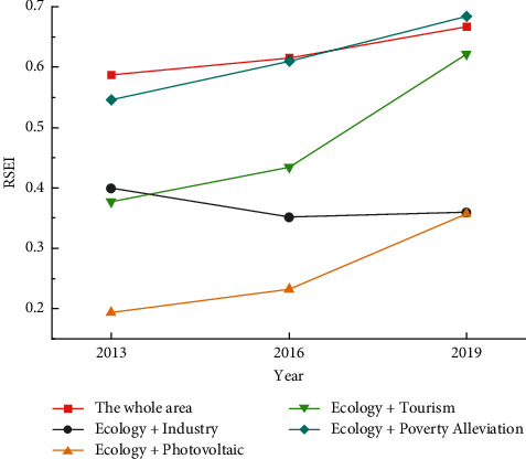
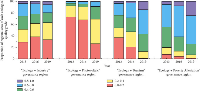
In order to meet the requirements for comprehensive and multidimensional generalization of ecological management effectiveness evaluation indexes in the context of ecological restoration advocating comprehensive management by multiple means, this paper explores the rationality of using RSEI as an ecological management effectiveness evaluation index to adapt to the systematic transformation of the management goal of abandoned mine restoration from ecological restoration to regional socioeconomic sustainable development. Based on Landsat-8 image data, the remote sensing ecological index (RSEI) was used to evaluate the dynamic changes and spatial and temporal differences of the ecological environment in the study area under the long-term multimeans comprehensive management. The RSEI is suitable for evaluating the effectiveness of comprehensive ecological management in mining areas with a large amount of bare soil. The regional RSEI mean value increased by 0.029 in the early stage and 0.051 in the later stage by fragmentation management, indicating a better effect of multimeans comprehensive management. The remote sensing ecological index can objectively reflect the difference of spatial distribution characteristics of ecological environment in the four "Ecological+" governance regions. It can both objectively reflect the ecological status of the study area and reflect the differentiated spatial distribution characteristics of the ecological environment in different treatment areas, which is of long-term practical significance to the ecological construction of the study area. This study provides a theoretical reference for ecological assessment of complex situation under difficult site conditions.

摘要

为了满足生态修复背景下综合多维概括生态管理效果评价指标的要求,提倡多种手段综合治理,本文探讨了使用 RSEI 作为生态管理效果评价指标的合理性,以适应废弃矿山修复管理目标从生态修复到区域社会经济可持续发展的系统转变。基于 Landsat-8 图像数据,利用遥感生态指数(RSEI)评价了长期多手段综合治理下研究区生态环境的动态变化及时空差异。RSEI 适用于评价大面积裸土矿区综合生态管理的效果。分区 RSEI 均值在碎化管理的早期和后期分别增加了 0.029 和 0.051,表明多手段综合治理效果较好。遥感生态指数可以客观反映四个“生态+”治理区生态环境空间分布特征的差异。既能客观反映研究区的生态状况,又能反映不同处理区生态环境的差异化空间分布特征,对研究区的生态建设具有长期的实际意义。本研究为复杂困难场地条件下的生态评估提供了理论参考。

https://cdn.ncbi.nlm.nih.gov/pmc/blobs/83c2/9303088/976db7e7578a/CIN2022-5335419.006.jpg
https://cdn.ncbi.nlm.nih.gov/pmc/blobs/83c2/9303088/63fdf708523a/CIN2022-5335419.001.jpg
https://cdn.ncbi.nlm.nih.gov/pmc/blobs/83c2/9303088/c95bb3d28eb4/CIN2022-5335419.002.jpg
https://cdn.ncbi.nlm.nih.gov/pmc/blobs/83c2/9303088/53be69b5b986/CIN2022-5335419.003.jpg
https://cdn.ncbi.nlm.nih.gov/pmc/blobs/83c2/9303088/ec979cbd358f/CIN2022-5335419.004.jpg
https://cdn.ncbi.nlm.nih.gov/pmc/blobs/83c2/9303088/f55ca9e65ec5/CIN2022-5335419.005.jpg
https://cdn.ncbi.nlm.nih.gov/pmc/blobs/83c2/9303088/976db7e7578a/CIN2022-5335419.006.jpg

相似文献

1
A Remote-Sensing Ecological Index Approach for Restoration Assessment of Rare-Earth Elements Mining.遥感生态指数法评估稀土元素采矿的恢复状况。
Comput Intell Neurosci. 2022 Jul 14;2022:5335419. doi: 10.1155/2022/5335419. eCollection 2022.
2
Evaluation of Remote Sensing Ecological Index Based on Soil and Water Conservation on the Effectiveness of Management of Abandoned Mine Landscaping Transformation.基于水土保持的遥感生态指数评价对废弃矿山景观改造管理成效的影响。
Int J Environ Res Public Health. 2022 Aug 8;19(15):9750. doi: 10.3390/ijerph19159750.
3
Ecological environment quality evaluation and evolution analysis of a rare earth mining area under different disturbance conditions.不同扰动条件下稀土矿区生态环境质量评价与演变分析。
Environ Geochem Health. 2021 Jun;43(6):2243-2256. doi: 10.1007/s10653-020-00761-6. Epub 2020 Nov 9.
4
Spatio-temporal evolutionary analysis of surface ecological quality in Pingshuo open-cast mine area, China.中国平朔露天矿区地表生态质量的时空演变分析。
Environ Sci Pollut Res Int. 2024 Jan;31(5):7312-7329. doi: 10.1007/s11356-023-31650-x. Epub 2023 Dec 29.
5
Monitoring the effects of open-pit mining on the eco-environment using a moving window-based remote sensing ecological index.运用基于移动窗口的遥感生态指数监测露天开采对生态环境的影响。
Environ Sci Pollut Res Int. 2020 May;27(13):15716-15728. doi: 10.1007/s11356-020-08054-2. Epub 2020 Feb 21.
6
Research on remote sensing ecological environmental assessment method optimized by regional scale.基于区域尺度的遥感生态环境评价方法优化研究
Environ Sci Pollut Res Int. 2021 Dec;28(48):68174-68187. doi: 10.1007/s11356-021-15262-x. Epub 2021 Jul 15.
7
Analysis of Spatial Heterogeneity and Influencing Factors of Ecological Environment Quality in China's North-South Transitional Zone.中国南北过渡带生态环境质量空间异质性及其影响因素分析。
Int J Environ Res Public Health. 2022 Feb 16;19(4):2236. doi: 10.3390/ijerph19042236.
8
[Ecological Environment Assessment and Driving Mechanism Analysis of Nagqu and Amdo Sections of Qinghai-Xizang Highway Based on Improved Remote Sensing Ecological Index].基于改进遥感生态指数的青藏公路那曲与安多段生态环境评价及驱动机制分析
Huan Jing Ke Xue. 2024 Mar 8;45(3):1586-1597. doi: 10.13227/j.hjkx.202303252.
9
Instability of remote sensing based ecological index (RSEI) and its improvement for time series analysis.基于遥感的生态指数(RSEI)的不稳定性及其在时间序列分析中的改进。
Sci Total Environ. 2022 Mar 25;814:152595. doi: 10.1016/j.scitotenv.2021.152595. Epub 2022 Jan 4.
10
Exploring the Driving Factors of Remote Sensing Ecological Index Changes from the Perspective of Geospatial Differentiation: A Case Study of the Weihe River Basin, China.从地理空间分异角度探究遥感生态指数变化的驱动因素:以中国渭河流域为例。
Int J Environ Res Public Health. 2022 Sep 1;19(17):10930. doi: 10.3390/ijerph191710930.

本文引用的文献

1
Assessment of spatial and temporal ecological environment quality under land use change of urban agglomeration in the North Slope of Tianshan, China.评估中国天山北坡城市群土地利用变化下的时空生态环境质量。
Environ Sci Pollut Res Int. 2022 Feb;29(8):12282-12299. doi: 10.1007/s11356-021-16579-3. Epub 2021 Sep 25.
2
Evaluation of potential ecological risks in potential toxic elements contaminated agricultural soils: Correlations between soil contamination and polymetallic mining activity.评价潜在有毒元素污染农田的潜在生态风险:土壤污染与多金属矿采活动的相关性。
J Environ Manage. 2021 Dec 15;300:113679. doi: 10.1016/j.jenvman.2021.113679. Epub 2021 Sep 9.
3
Research on remote sensing ecological environmental assessment method optimized by regional scale.
基于区域尺度的遥感生态环境评价方法优化研究
Environ Sci Pollut Res Int. 2021 Dec;28(48):68174-68187. doi: 10.1007/s11356-021-15262-x. Epub 2021 Jul 15.
4
Spatiotemporal ecological quality assessment of metropolitan cities: a case study of central Iran.大都市时空生态质量评估:以伊朗中部为例。
Environ Monit Assess. 2021 Apr 26;193(5):305. doi: 10.1007/s10661-021-09082-2.
5
Spatiotemporal ecological vulnerability analysis with statistical correlation based on satellite remote sensing in Samara, Russia.基于卫星遥感的俄罗斯萨马拉时空生态脆弱性分析与统计相关。
J Environ Manage. 2021 May 1;285:112138. doi: 10.1016/j.jenvman.2021.112138. Epub 2021 Feb 14.
6
Ecological environment quality evaluation and evolution analysis of a rare earth mining area under different disturbance conditions.不同扰动条件下稀土矿区生态环境质量评价与演变分析。
Environ Geochem Health. 2021 Jun;43(6):2243-2256. doi: 10.1007/s10653-020-00761-6. Epub 2020 Nov 9.
7
Ecological Risk Assessment of Heavy Metals in Water Bodies around Typical Copper Mines in China.中国典型铜矿周边水体中重金属的生态风险评估。
Int J Environ Res Public Health. 2020 Jun 17;17(12):4315. doi: 10.3390/ijerph17124315.
8
Remote sensing monitoring of land damage and restoration in rare earth mining areas in 6 counties in southern Jiangxi based on multisource sequential images.基于多源时序影像的赣南 6 县稀土矿区土地损毁与复垦遥感监测。
J Environ Manage. 2020 Aug 1;267:110653. doi: 10.1016/j.jenvman.2020.110653. Epub 2020 Apr 29.
9
Monitoring the effects of open-pit mining on the eco-environment using a moving window-based remote sensing ecological index.运用基于移动窗口的遥感生态指数监测露天开采对生态环境的影响。
Environ Sci Pollut Res Int. 2020 May;27(13):15716-15728. doi: 10.1007/s11356-020-08054-2. Epub 2020 Feb 21.
10
Quantitative Evaluation of the Eco-Environment in a Coalfield Based on Multi-Temporal Remote Sensing Imagery: A Case Study of Yuxian, China.基于多时相遥感影像的矿区生态环境定量评价——以中国盂县为例。
Int J Environ Res Public Health. 2019 Feb 12;16(3):511. doi: 10.3390/ijerph16030511.