Ghosh Soumen, Mistri Biswaranjan
Department of Geography, The University of Burdwan, Bardhaman, West Bengal 713104 India.
Nat Hazards (Dordr). 2023;116(3):3857-3878. doi: 10.1007/s11069-023-05840-2. Epub 2023 Feb 14.
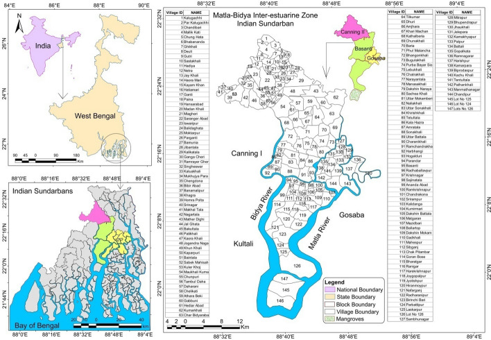
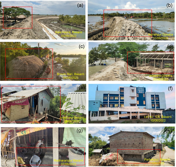
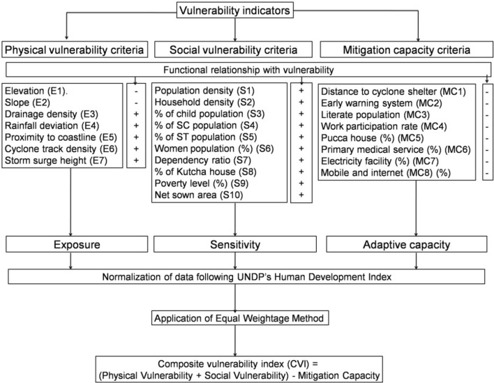
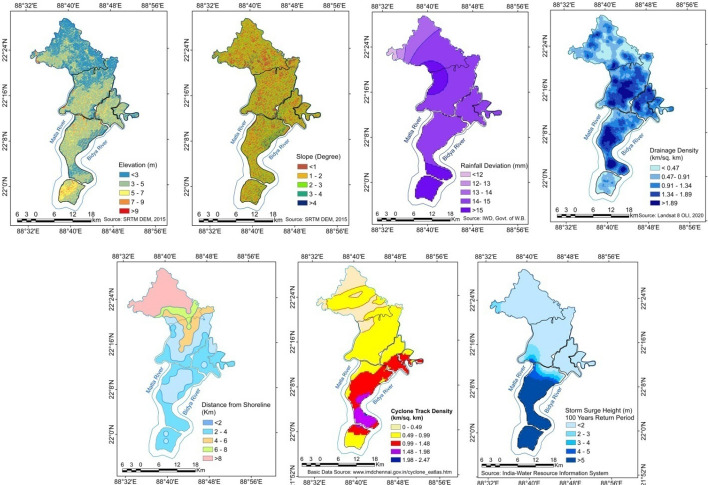
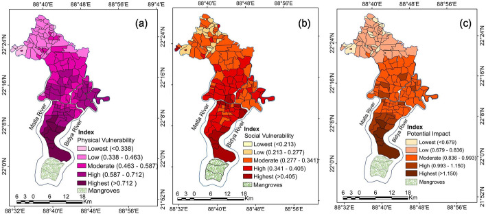
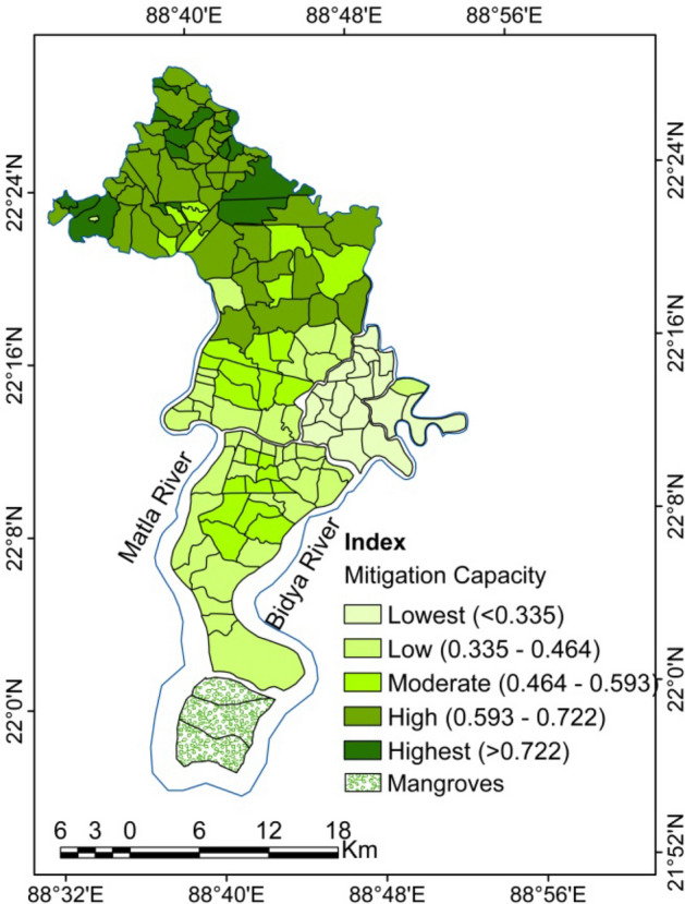
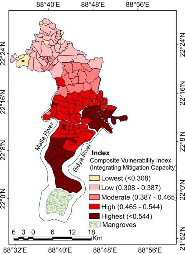
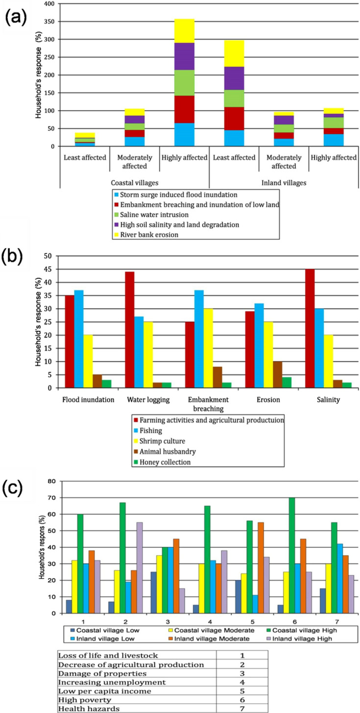
Indian Sundarban is highly susceptible to tropical cyclones and resultant impacts such as storm surge-induced floods, embankment breaching, and saline water intrusion. It affects life and livelihood in severe ways. Mitigation and policy measures are therefore very important, based on information gathered at the grassroots level. Hence, this study is designed to assess inter-village variation in cyclone vulnerability, considering physical vulnerability, social vulnerability, and mitigation capacity. This study also highlights livelihood challenges faced by coastal dwellers. Geospatial and quantitative methods were used to assess the composite vulnerability index (CVI). Remote sensing data and climatic data were integrated to assess physical vulnerability and various socioeconomic data were incorporated to determine the social vulnerability. Moreover, an intensive field survey (2020-2021) was also conducted to understand the livelihood challenges of local people and accordingly suggest mitigation measures to cope with natural hazards. According to this analysis, nearly 18% of the total population living in the southern and eastern parts of the Matla-Bidya inter-estuarine area (MBI) are extremely vulnerable (CVI > 0.544) due to their geographical location and high exposure to coastal hazards. Almost 51% of the total populations inhabited in 46% of the total MBI villages are experiencing high to moderate vulnerability. Conversely, MBI villages in the northern part, where 32% of the total population lives, show low vulnerability (CVI < 0.387) due to less exposure and high resilience. Coastal low-lying villages are often hardest hit by tropical cyclones. Therefore, effective mitigation strategies and coping mechanisms are essentially needed to reduce the adverse impacts of cyclones.
印度孙德尔本斯极易受到热带气旋及其带来的影响,如风暴潮引发的洪水、堤坝决口和海水入侵。它对生命和生计造成严重影响。因此,基于基层收集的信息,减灾和政策措施非常重要。因此,本研究旨在评估村庄间在气旋脆弱性方面的差异,考虑物理脆弱性、社会脆弱性和减灾能力。本研究还突出了沿海居民面临的生计挑战。采用地理空间和定量方法评估综合脆弱性指数(CVI)。整合遥感数据和气候数据以评估物理脆弱性,并纳入各种社会经济数据以确定社会脆弱性。此外,还开展了一项密集的实地调查(2020 - 2021年),以了解当地居民的生计挑战,并据此提出应对自然灾害的减灾措施。根据该分析,由于地理位置和对沿海灾害的高暴露度,生活在马特拉克河 - 比迪亚河河口间地区(MBI)南部和东部的总人口中近18%极易受到影响(CVI > 0.544)。居住在MBI地区46%的村庄中的总人口中近51%正经历高到中度的脆弱性。相反,北部的MBI村庄,有32%的总人口居住在那里,由于暴露度较低和恢复力较高,显示出低脆弱性(CVI < 0.387)。沿海低洼村庄往往受热带气旋影响最严重。因此,迫切需要有效的减灾策略和应对机制来减少气旋的不利影响。