Xiao Hai-Yan, Chai Jong-Yil, Fang Yue-Yi, Lai Ying-Si
Department of Medical Statistics, School of Public Health, Sun Yat-sen University, Guangzhou, Guangdong, PR China.
Department of Parasitology and Tropical Medicine, Seoul National University College of Medicine, and Institute of Endemic Diseases, Seoul National University Medical Research Center, Seoul, 110-799, South Korea.
Lancet Reg Health West Pac. 2023 Feb 3;33:100697. doi: 10.1016/j.lanwpc.2023.100697. eCollection 2023 Apr.
Over the past 50 years, two national control programs on infection have been conducted in South Korea. Spatial-temporal profiles of infection risk provide useful information on assessing the effectiveness of the programs and planning spatial-targeted control strategies.
Advanced Bayesian geostatistical joint models with spatial-temporal random effects were developed to analyze disease data collecting by a systematic review with potential influencing factors, and to handle issues of preferential sampling and data heterogeneities. Changes of the infection risk were analyzed.
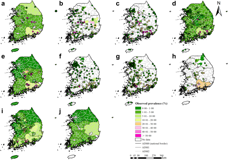
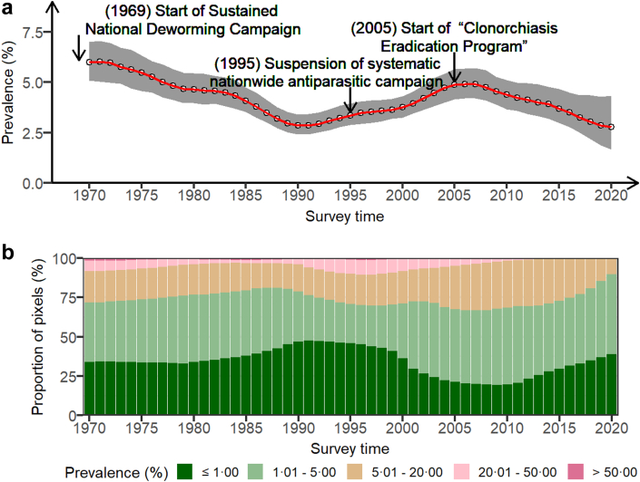
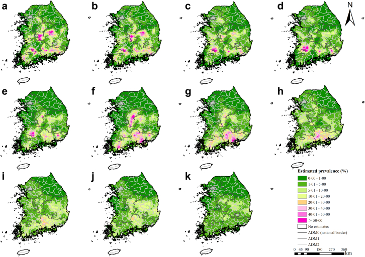
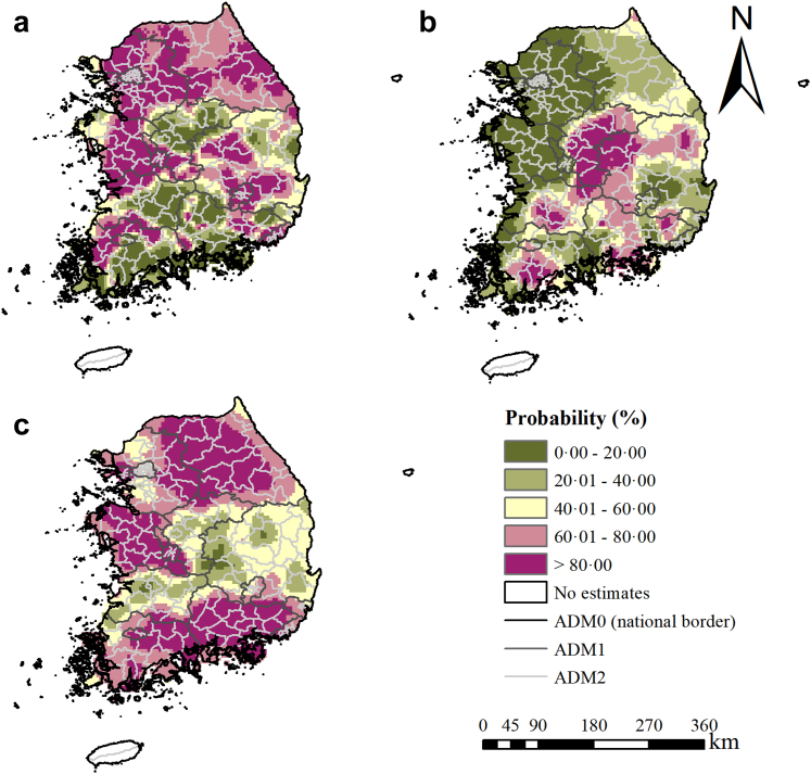
We presented the first spatial-temporal risk maps of infection at 5 × 5 km resolution from 1970 to 2020 in South Korea. Moderate-to-high risk areas were shrunk, but temporal variances were shown in different areas. The population-adjusted estimated prevalence across the country was 5.99% (95% BCI: 5.09-7.01%) in 1970, when the first national deworming campaign began. It declined to 3.95% (95% BCI: 2.88-3.95%) in 1995, when the campaign suspended, and increased to 4.73% (95% BCI: 4.00-5.42%) in 2004, just before the Clonorchiasis Eradication Program (CEP). The population-adjusted prevalence was estimated at 2.77% (95% BCI: 1.67-4.34%) in 2020, 15 years after CEP started, corresponding to 1.42 (95% BCI: 0.85-2.23) million infected people.
The first nationwide campaign and the CEP showed effectiveness on control of infection. Moderate-to-high risk areas identified by risk maps should be prioritized for control and intervention.
The National Natural Science Foundation of China (project no. 82073665) and the Natural Science Foundation of Guangdong Province (project no. 2022A1515010042).
在过去50年里,韩国实施了两项全国性感染控制项目。感染风险的时空分布为评估这些项目的有效性以及制定空间靶向控制策略提供了有用信息。
开发了具有时空随机效应的先进贝叶斯地理统计联合模型,以分析通过系统综述收集的疾病数据及潜在影响因素,并处理优先抽样和数据异质性问题。分析了感染风险的变化。
我们展示了韩国1970年至2020年5×5公里分辨率下的首张感染时空风险地图。中高风险区域有所缩小,但不同区域存在时间差异。1970年首次全国驱虫运动开始时,全国经人口调整后的估计患病率为5.99%(95%贝叶斯可信区间:5.09%-7.01%)。1995年该运动暂停时,患病率降至3.95%(95%贝叶斯可信区间:2.88%-3.95%),2004年,即华支睾吸虫病根除项目(CEP)启动前夕,患病率升至4.73%(95%贝叶斯可信区间:4.00%-5.42%)。CEP启动15年后的2020年,经人口调整后的患病率估计为2.77%(95%贝叶斯可信区间:1.67%-4.34%),相当于142万(95%贝叶斯可信区间:85万-223万)感染者。
首次全国性运动和CEP在控制感染方面显示出有效性。风险地图确定的中高风险区域应优先进行控制和干预。
中国国家自然科学基金(项目编号:82073665)和广东省自然科学基金(项目编号:2022A1515010042)。