RMIT University, Centre for Urban Research, Melbourne, 3000, Australia.
Australian Urban Design Research Centre, University of Western Australia, Perth, 6009, Australia.
Sci Data. 2023 Feb 25;10(1):113. doi: 10.1038/s41597-023-02013-5.
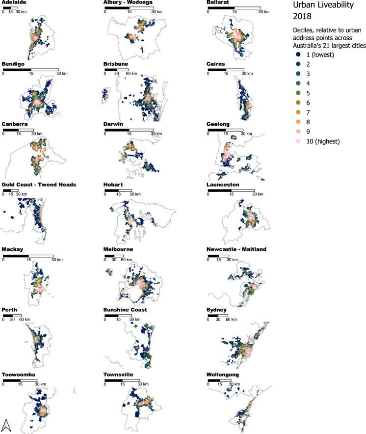
Measuring and monitoring the spatial distribution of liveability is crucial to ensure that implemented urban and transport planning decisions support health and wellbeing. Spatial liveability indicators can be used to ensure these decisions are effective, equitable and tracked across time. The 2018 Australian National Liveability Study datasets comprise a suite of policy-relevant health-related spatial indicators of local neighbourhood liveability and amenity access estimated for residential address points and administrative areas across Australia's 21 most populous cities. The indicators and measures encompass access to community and health services, social infrastructure, employment, food, housing, public open space, transportation, walkability and overall liveability. This national 'baseline' liveability indicators dataset for residential address points and areas can be further linked with surveys containing geocoded participant locations, as well as Census data for areas from the Australian Statistical Geography Standard. The datasets will be of interest to planners, policy makers and researchers interested in modelling and mapping the spatial distribution of urban environmental exposures and their relationship with health and other outcomes.
衡量和监测宜居性的空间分布对于确保实施的城市和交通规划决策能够支持健康和幸福感至关重要。空间宜居性指标可用于确保这些决策具有有效性、公平性,并能够随着时间的推移进行跟踪。2018 年澳大利亚国家宜居性研究数据集包含一系列与政策相关的健康相关空间指标,用于估计澳大利亚 21 个人口最多的城市的居民住址点和行政区域的当地社区宜居性和便利设施可达性。这些指标和措施包括获得社区和卫生服务、社会基础设施、就业、食品、住房、公共开放空间、交通、可步行性和整体宜居性。这个针对居民住址点和区域的全国“基线”宜居性指标数据集可以与包含地理编码参与者位置的调查以及澳大利亚统计地理标准区域的人口普查数据进一步关联。这些数据集将引起规划者、政策制定者和研究人员的兴趣,他们有兴趣对城市环境暴露的空间分布及其与健康和其他结果的关系进行建模和制图。