• 文献检索
  • 文档翻译
  • 深度研究
  • 学术资讯
  • Suppr Zotero 插件Zotero 插件
  • 邀请有礼
  • 套餐&价格
  • 历史记录
应用&插件
Suppr Zotero 插件Zotero 插件浏览器插件Mac 客户端Windows 客户端微信小程序
定价
高级版会员购买积分包购买API积分包
服务
文献检索文档翻译深度研究API 文档MCP 服务
关于我们
关于 Suppr公司介绍联系我们用户协议隐私条款
关注我们

Suppr 超能文献

核心技术专利:CN118964589B侵权必究
粤ICP备2023148730 号-1Suppr @ 2026

文献检索

告别复杂PubMed语法,用中文像聊天一样搜索,搜遍4000万医学文献。AI智能推荐,让科研检索更轻松。

立即免费搜索

文件翻译

保留排版,准确专业,支持PDF/Word/PPT等文件格式,支持 12+语言互译。

免费翻译文档

深度研究

AI帮你快速写综述,25分钟生成高质量综述,智能提取关键信息,辅助科研写作。

立即免费体验

利用地理信息系统(GIS)从数字高程模型(DEM)中模拟水文因素。

Modelling hydrological factors from DEM using GIS.

作者信息

Chowdhury Md Sharafat

机构信息

Information and Communication Technology Division, Government of Bangladesh; Department of Geography and Environment, Jahangirnagar University, Dhaka, Bangladesh.

出版信息

MethodsX. 2023 Feb 6;10:102062. doi: 10.1016/j.mex.2023.102062. eCollection 2023.

DOI:10.1016/j.mex.2023.102062
PMID:36845367
原文链接:https://pmc.ncbi.nlm.nih.gov/articles/PMC9945793/
Abstract

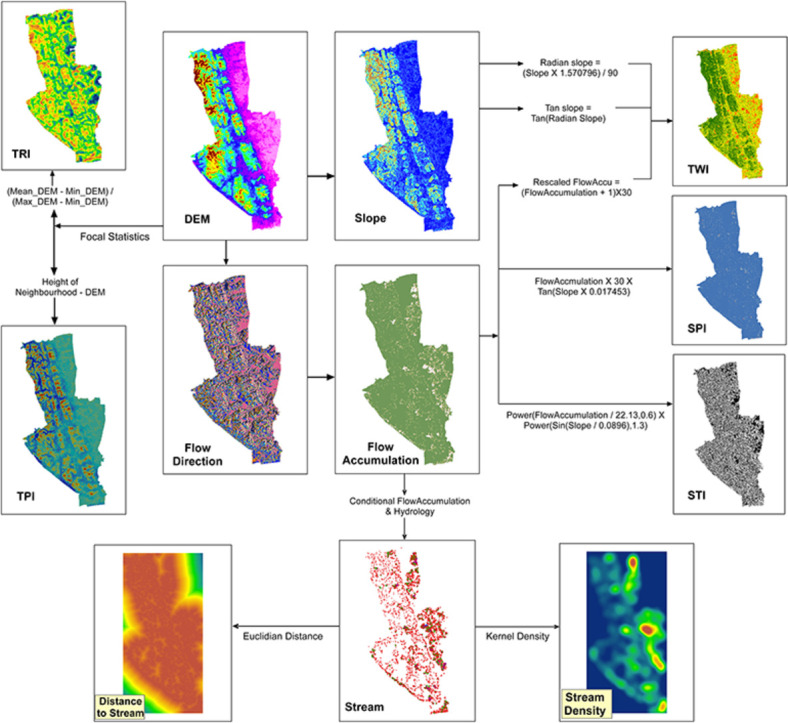
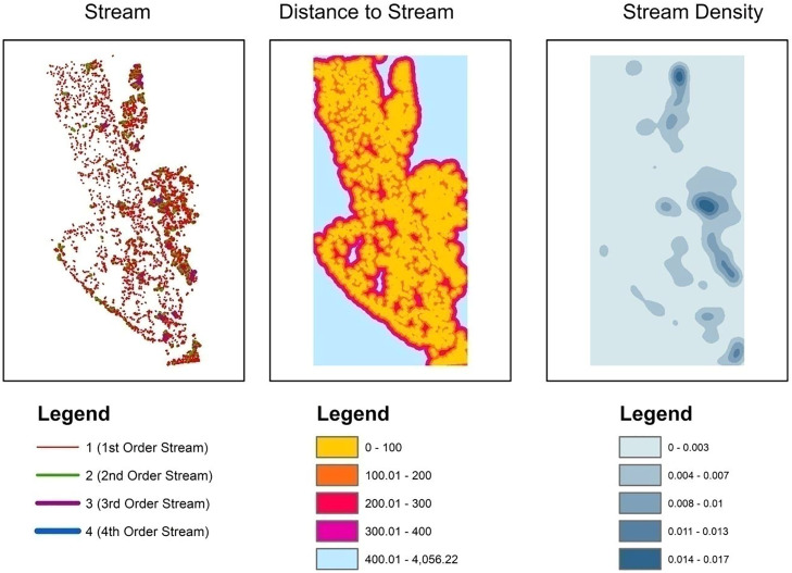
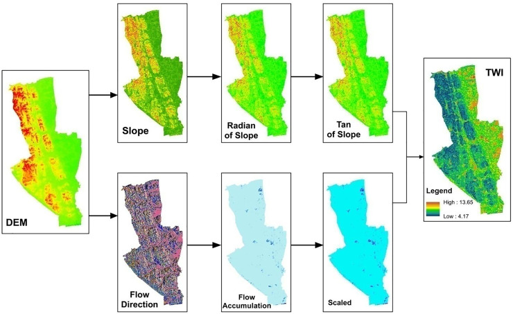
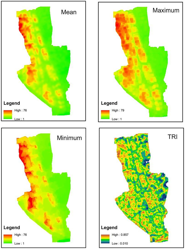
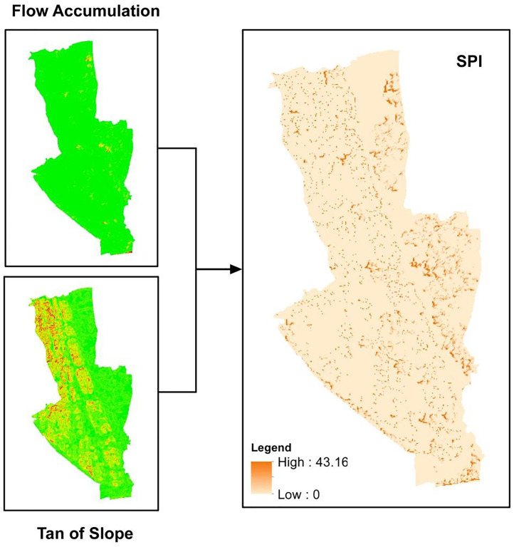
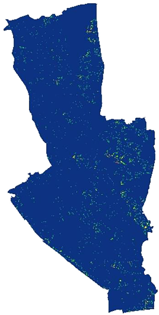
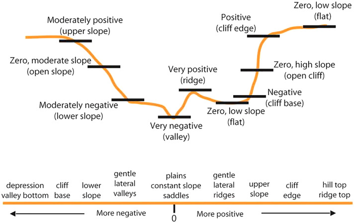
Hydrological modelling is a precondition for many scientific researches such as species distribution models, ecological models, agricultural suitability models, climatological models, hydrological models, flood and flash flood models, landslide models etc. Even the topographic control over many hydrological factors has also been studied. Over time different hydrological models have been developed and extensively used. Recently, these models have been used to prepare different types of conditional factors that are widely used in hazard modelling such as floods, flash floods, landslides etc. Quantitative analysis of the Digital Elevation Model (DEM) according to different models by engaging Geographic Information Systems (GIS) supports users to extract various types of information about landscapes where hydrological and topographic information are most important. Methods to prepare hydrological factors namely TWI, TRI, SPI, STI, TPI, stream density and distance to stream by processing DEM in GIS are discussed in this paper. These common hydrological factors are extensively used in many scientific research papers either for modelling or to measure their relationship with other environmental factors.•Hydrological factors have great importance in understanding the landscape and are widely used in scientific research, especially geo-environmental hazard mapping.•Physically based hydrological methods are engaged in ArcMap 10.5 software.•Commonly used hydrological factors are processed using freely available DEM and ArcMap 10.5 software.

摘要

水文建模是许多科学研究的前提条件,如物种分布模型、生态模型、农业适宜性模型、气候模型、水文模型、洪水和山洪暴发模型、滑坡模型等。甚至对许多水文因素的地形控制也已得到研究。随着时间的推移,不同的水文模型得到了开发和广泛应用。最近,这些模型已被用于准备不同类型的条件因素,这些因素在洪水、山洪暴发、滑坡等灾害建模中被广泛使用。通过地理信息系统(GIS)根据不同模型对数字高程模型(DEM)进行定量分析,支持用户提取有关水文和地形信息最为重要的景观的各种类型信息。本文讨论了在GIS中通过处理DEM来准备水文因素(即地形湿度指数、地形粗糙度指数、坡度位置指数、地形湿度指数、地形位置指数、河流密度和到河流的距离)的方法。这些常见的水文因素在许多科学研究论文中被广泛用于建模或测量它们与其他环境因素的关系。

•水文因素在理解景观方面具有重要意义,并且在科学研究中广泛使用,特别是在地质环境灾害制图中。

•基于物理的水文方法在ArcMap 10.5软件中使用。

•常用的水文因素使用免费的DEM和ArcMap 10.5软件进行处理。

https://cdn.ncbi.nlm.nih.gov/pmc/blobs/12cd/9945793/6c41c55d9563/gr8.jpg
https://cdn.ncbi.nlm.nih.gov/pmc/blobs/12cd/9945793/fc6c4aad42b7/ga1.jpg
https://cdn.ncbi.nlm.nih.gov/pmc/blobs/12cd/9945793/2303ae900e86/gr1.jpg
https://cdn.ncbi.nlm.nih.gov/pmc/blobs/12cd/9945793/7356fa3f6ef2/gr2.jpg
https://cdn.ncbi.nlm.nih.gov/pmc/blobs/12cd/9945793/354383e0ff85/gr3.jpg
https://cdn.ncbi.nlm.nih.gov/pmc/blobs/12cd/9945793/e2aead85eca0/gr4.jpg
https://cdn.ncbi.nlm.nih.gov/pmc/blobs/12cd/9945793/35499398078d/gr5.jpg
https://cdn.ncbi.nlm.nih.gov/pmc/blobs/12cd/9945793/4ba25f8fad72/gr6.jpg
https://cdn.ncbi.nlm.nih.gov/pmc/blobs/12cd/9945793/5634848ce69e/gr7.jpg
https://cdn.ncbi.nlm.nih.gov/pmc/blobs/12cd/9945793/6c41c55d9563/gr8.jpg

相似文献

1
Modelling hydrological factors from DEM using GIS.利用地理信息系统(GIS)从数字高程模型(DEM)中模拟水文因素。
MethodsX. 2023 Feb 6;10:102062. doi: 10.1016/j.mex.2023.102062. eCollection 2023.
2
GIS-based multicriteria decision analysis for settlement areas: a case study in Canik.基于地理信息系统的定居点多准则决策分析:以卡尼克为例
Environ Sci Pollut Res Int. 2022 May;29(24):35746-35759. doi: 10.1007/s11356-021-17970-w. Epub 2022 Jan 21.
3
Application of geographical information system-based analytical hierarchy process modeling for flood susceptibility mapping of Krishna District in Andhra Pradesh.基于地理信息系统的层次分析模型在安得拉邦克里希纳区洪水易发性制图中的应用。
Environ Sci Pollut Res Int. 2023 Sep;30(44):99062-99075. doi: 10.1007/s11356-022-22924-x. Epub 2022 Sep 10.
4
Data Mining and Statistical Approaches in Debris-Flow Susceptibility Modelling Using Airborne LiDAR Data.利用机载激光雷达数据进行泥石流易发性建模中的数据挖掘与统计方法
Sensors (Basel). 2019 Aug 7;19(16):3451. doi: 10.3390/s19163451.
5
Soil erodibility mapping of hilly watershed using analytical hierarchy process and geographical information system: A case of Chittagong hill tract, Bangladesh.利用层次分析法和地理信息系统绘制丘陵流域土壤可蚀性图:以孟加拉国吉大港山区为例
Heliyon. 2024 Feb 22;10(5):e26728. doi: 10.1016/j.heliyon.2024.e26728. eCollection 2024 Mar 15.
6
A Multi-Sensor Comparative Analysis on the Suitability of Generated DEM from Sentinel-1 SAR Interferometry Using Statistical and Hydrological Models.基于统计模型和水文模型对哨兵-1合成孔径雷达干涉测量生成数字高程模型适用性的多传感器对比分析
Sensors (Basel). 2020 Dec 16;20(24):7214. doi: 10.3390/s20247214.
7
Debris flow-induced topographic changes: effects of recurrent debris flow initiation.泥石流引发的地形变化:反复发生泥石流引发的影响
Environ Monit Assess. 2017 Aug 12;189(9):449. doi: 10.1007/s10661-017-6169-y.
8
Flash flood susceptibility analysis and its mapping using different bivariate models in Iran: a comparison between Shannons entropy, statistical index, and weighting factor models.伊朗不同双变量模型的暴洪易发性分析及其制图:香农熵、统计指数和加权因子模型的比较
Environ Monit Assess. 2016 Dec;188(12):656. doi: 10.1007/s10661-016-5665-9. Epub 2016 Nov 8.
9
Evaluating scale effects of topographic variables in landslide susceptibility models using GIS-based machine learning techniques.利用基于地理信息系统的机器学习技术评估滑坡易发性模型中地形变量的尺度效应。
Sci Rep. 2019 Aug 23;9(1):12296. doi: 10.1038/s41598-019-48773-2.
10
Flash Flood Vulnerability Mapping Based on FFPI Using GIS Spatial Analysis Case Study: Valea Rea Catchment Area, Romania.基于 FFPI 的 Flash Flood Vulnerability Mapping 及 GIS 空间分析案例研究:罗马尼亚雷亚谷流域。
Sensors (Basel). 2022 May 7;22(9):3573. doi: 10.3390/s22093573.

引用本文的文献

1
Utilizing multi-criteria decision-making analysis and 3D visualization techniques for dam site selection and irrigation area identification in Gedeb River, Ethiopia.利用多标准决策分析和3D可视化技术进行埃塞俄比亚格德布河坝址选择和灌区识别。
Heliyon. 2024 Aug 2;10(15):e35604. doi: 10.1016/j.heliyon.2024.e35604. eCollection 2024 Aug 15.

本文引用的文献

1
Topography regulates the responses of water partitioning to climate and vegetation seasonality.地形调节水分分配对气候和植被季节性的响应。
Sci Total Environ. 2022 Sep 10;838(Pt 2):156028. doi: 10.1016/j.scitotenv.2022.156028. Epub 2022 May 17.
2
Topographic Wetness Index calculation guidelines based on measured soil moisture and plant species composition.基于实测土壤水分和植物物种组成的地形湿润指数计算指南。
Sci Total Environ. 2021 Feb 25;757:143785. doi: 10.1016/j.scitotenv.2020.143785. Epub 2020 Nov 14.
3
Application of hydrological indices for erosion hazard mapping using Spatial Analyst tool.
利用 Spatial Analyst 工具进行水文指标在侵蚀危险制图中的应用。
Environ Monit Assess. 2019 Jul 4;191(8):482. doi: 10.1007/s10661-019-7614-x.