• 文献检索
  • 文档翻译
  • 深度研究
  • 学术资讯
  • Suppr Zotero 插件Zotero 插件
  • 邀请有礼
  • 套餐&价格
  • 历史记录
应用&插件
Suppr Zotero 插件Zotero 插件浏览器插件Mac 客户端Windows 客户端微信小程序
定价
高级版会员购买积分包购买API积分包
服务
文献检索文档翻译深度研究API 文档MCP 服务
关于我们
关于 Suppr公司介绍联系我们用户协议隐私条款
关注我们

Suppr 超能文献

核心技术专利:CN118964589B侵权必究
粤ICP备2023148730 号-1Suppr @ 2026

文献检索

告别复杂PubMed语法,用中文像聊天一样搜索,搜遍4000万医学文献。AI智能推荐,让科研检索更轻松。

立即免费搜索

文件翻译

保留排版,准确专业,支持PDF/Word/PPT等文件格式,支持 12+语言互译。

免费翻译文档

深度研究

AI帮你快速写综述,25分钟生成高质量综述,智能提取关键信息,辅助科研写作。

立即免费体验

评估孟加拉国中部沿海地区与水动力相关的长期地貌过程。

Evaluating the long-term geomorphic process in-relation to hydrodynamics in the central coastal zone of Bangladesh.

作者信息

Sultana Tania, Islam Md Tariqul, Rahman Md Shajjadur, Siddique Abu Bokkar, Huda A N M Samiul, Sarker Subrata

机构信息

Department of Geography and Environment, Shahjalal University of Science and Technology, Sylhet, 3114, Bangladesh.

Department of Oceanography, Shahjalal University of Science and Technology, Sylhet, 3114, Bangladesh.

出版信息

Heliyon. 2023 Jun 15;9(6):e17368. doi: 10.1016/j.heliyon.2023.e17368. eCollection 2023 Jun.

DOI:10.1016/j.heliyon.2023.e17368
PMID:37441399
原文链接:https://pmc.ncbi.nlm.nih.gov/articles/PMC10333623/
Abstract

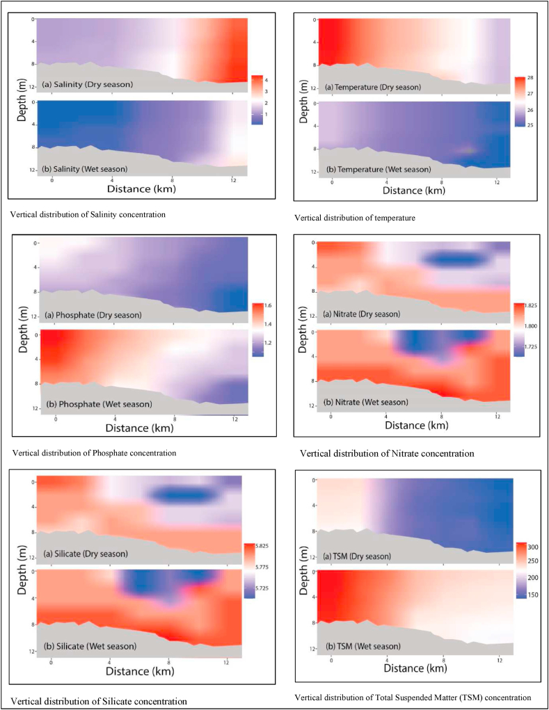
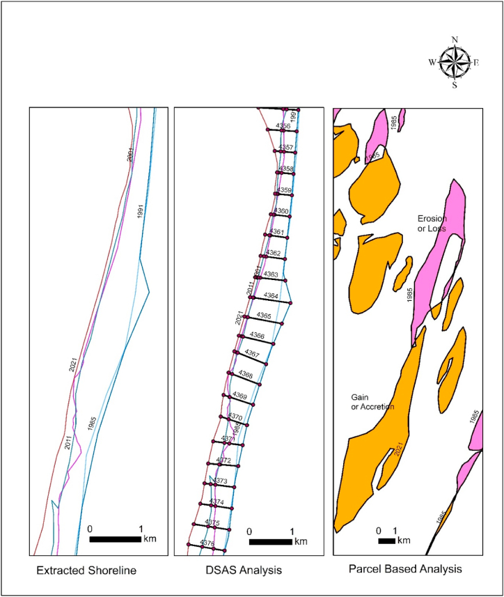
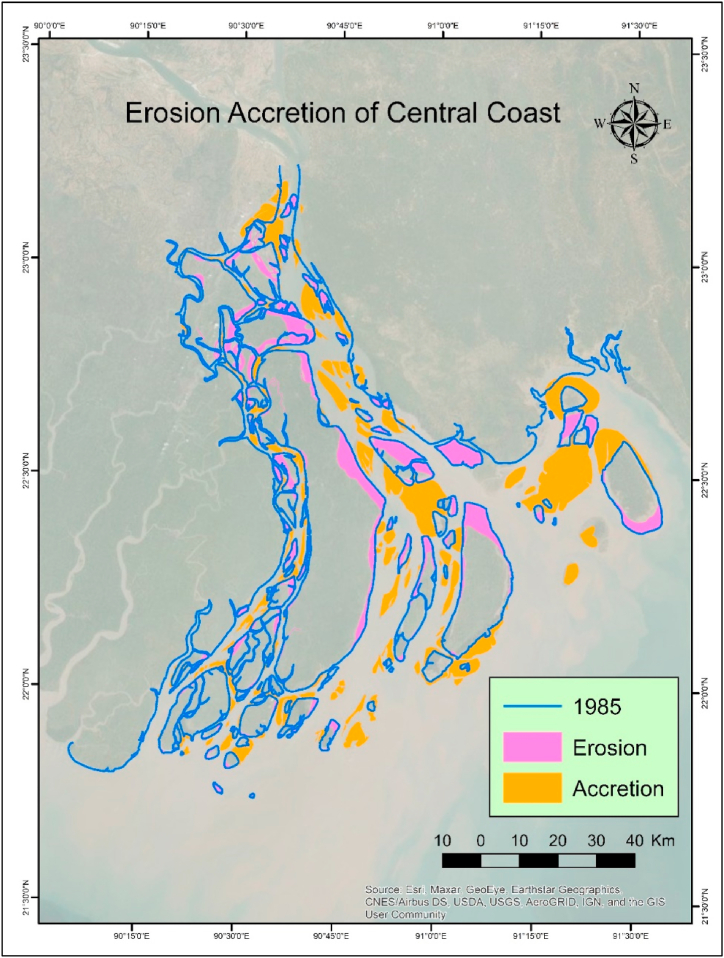
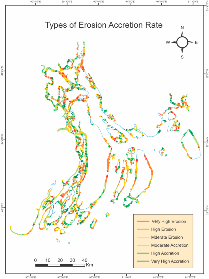
The central coast of Bangladesh is dynamic for its geographical location, hydrodynamic characteristics and residual flow. The research employed the Digital Shoreline Analysis System (DSAS), an ArcGIS extension tool, to conduct a historical trend analysis of shoreline. The study demonstrates that the central coast is eroding to the north and accreting to the south. The highest accretion value was found as 195.42 m/year, whereas the maximum value of erosion was estimated as -185.83 m/year, according to End Point Rate (EPR). The Linear Regression Rate (LRR) indicates that the average rate of erosion and accretion are -17.77 m/year and 17.88 m/year, respectively. Meanwhile, using Weighted Linear Regression (WLR), 0.48% of all transects demonstrated statistically significant erosion, while 0.43% showed statistically significant accretion. During the wet season, heavy river discharge leads to a low salt level in the ocean. Ocean currents hit central coast of Bangladesh from east to west, affecting the majority of the islands in the Meghna Estuary in the dry season. Changes in current directions can be seen during the wet seasons. Southern central coast areas are hit by south-east currents that split in two directions. The Sandwip Channel has a flow of 10,000 to 15,000 m³ s northward. The Tetulia River, Shahbazpur Channel, and Hatia-Sandwip flow southward at rates ranging from 3000 to 17,000 m³ s, 14,000 to 60,000 m³ s, and 7000 to 39,000 m³ s, respectively. In the Meghna Estuary, the combined forces result in a counter-clockwise residual circulation, with the northward flow in the Sandwip channel and southbound flow in the Hatia and Shahbazpur channels. As a result of hydrodynamic, ocean currents, and residual flow, the Central Coast of Bangladesh is continually changing in appearance.

摘要

孟加拉国中部海岸因其地理位置、水动力特征和余流而充满活力。该研究采用了数字海岸线分析系统(DSAS),这是一种ArcGIS扩展工具,对海岸线进行历史趋势分析。研究表明,中部海岸北部正在侵蚀,南部正在淤积。根据终点速率(EPR),最高淤积值为195.42米/年,而最大侵蚀值估计为-185.83米/年。线性回归速率(LRR)表明,侵蚀和淤积的平均速率分别为-17.77米/年和17.88米/年。同时,使用加权线性回归(WLR),所有断面中有0.48%显示出具有统计学意义的侵蚀,而0.43%显示出具有统计学意义的淤积。在雨季,河流大量排放导致海洋盐度降低。洋流从东向西冲击孟加拉国中部海岸,在旱季影响梅克纳河口的大部分岛屿。在雨季可以看到洋流方向的变化。中部海岸南部地区受到向两个方向分流的东南洋流的冲击。桑德维普海峡向北的流量为10000至15000立方米/秒。特图利亚河、沙阿巴兹布尔海峡和哈蒂亚-桑德维普分别以3000至17000立方米/秒、14000至60000立方米/秒和7000至39000立方米/秒的速率向南流动。在梅克纳河口,这些合力导致了逆时针方向的余环流,桑德维普海峡向北流动,哈蒂亚和沙阿巴兹布尔海峡向南流动。由于水动力、洋流和余流的作用,孟加拉国中部海岸的面貌在不断变化。

https://cdn.ncbi.nlm.nih.gov/pmc/blobs/401e/10333623/18b72b79b39c/gr8.jpg
https://cdn.ncbi.nlm.nih.gov/pmc/blobs/401e/10333623/5a4dfac4d6c4/gr1.jpg
https://cdn.ncbi.nlm.nih.gov/pmc/blobs/401e/10333623/e36e014e3edf/gr2.jpg
https://cdn.ncbi.nlm.nih.gov/pmc/blobs/401e/10333623/e780fee412c2/gr3.jpg
https://cdn.ncbi.nlm.nih.gov/pmc/blobs/401e/10333623/7ae4d1e04e95/gr4.jpg
https://cdn.ncbi.nlm.nih.gov/pmc/blobs/401e/10333623/6806f1c08743/gr5.jpg
https://cdn.ncbi.nlm.nih.gov/pmc/blobs/401e/10333623/51232994fa8a/gr6.jpg
https://cdn.ncbi.nlm.nih.gov/pmc/blobs/401e/10333623/2b316b43d314/gr7.jpg
https://cdn.ncbi.nlm.nih.gov/pmc/blobs/401e/10333623/18b72b79b39c/gr8.jpg

相似文献

1
Evaluating the long-term geomorphic process in-relation to hydrodynamics in the central coastal zone of Bangladesh.评估孟加拉国中部沿海地区与水动力相关的长期地貌过程。
Heliyon. 2023 Jun 15;9(6):e17368. doi: 10.1016/j.heliyon.2023.e17368. eCollection 2023 Jun.
2
A quantitative analysis of multi-decadal shoreline changes along the East Coast of South Korea.韩国东海岸数十年来的海岸线变化定量分析。
Sci Total Environ. 2023 Jun 10;876:162756. doi: 10.1016/j.scitotenv.2023.162756. Epub 2023 Mar 13.
3
Analysis of long- and short-term shoreline change dynamics: A study case of João Pessoa city in Brazil.分析岸线长期和短期变化动态:巴西若昂佩索阿市的研究案例。
Sci Total Environ. 2021 May 15;769:144889. doi: 10.1016/j.scitotenv.2020.144889. Epub 2021 Jan 14.
4
Response of long- to short-term tidal inlet morphodynamics on the ecological ramification of Chilika lake, the tropical Ramsar wetland in India.印度热带拉塞尔湿地奇利卡湖的长期和短期潮流入口形态响应对生态的影响。
Sci Total Environ. 2022 Feb 10;807(Pt 2):150769. doi: 10.1016/j.scitotenv.2021.150769. Epub 2021 Oct 5.
5
Quantitative assessment of present and the future potential threat of coastal erosion along the Odisha coast using geospatial tools and statistical techniques.利用地理空间工具和统计技术定量评估奥里萨邦沿海地区当前和未来的海岸侵蚀潜在威胁。
Sci Total Environ. 2023 Jun 1;875:162488. doi: 10.1016/j.scitotenv.2023.162488. Epub 2023 Feb 28.
6
A multi-temporal analysis of shoreline dynamics influenced by natural and anthropogenic factors: Erosion and accretion along the Digha Coast, West Bengal, India.受自然和人为因素影响的海岸线动态多时态分析:印度西孟加拉邦迪加海岸的侵蚀与堆积
Mar Pollut Bull. 2024 Mar;200:116089. doi: 10.1016/j.marpolbul.2024.116089. Epub 2024 Feb 19.
7
Statistical analysis of shoreline change reveals erosion and baseline are increasing off the northern Tamil Nadu Coasts of India.海岸线变化的统计分析显示,印度泰米尔纳德邦北部海岸沿线的侵蚀和基线正在增加。
Environ Monit Assess. 2023 Feb 17;195(3):409. doi: 10.1007/s10661-023-11015-0.
8
Applying geospatial technology in quantifying spatiotemporal shoreline dynamics along Marina El-Alamein Resort, Egypt.运用地理空间技术定量分析埃及马雷纳·阿勒阿莱姆度假区的岸线时空动态变化。
Environ Monit Assess. 2020 Jun 27;192(7):459. doi: 10.1007/s10661-020-08432-w.
9
Monitoring of Chilika Lake mouth dynamics and quantifying rate of shoreline change using 30 m multi-temporal Landsat data.利用30米多时相陆地卫星数据监测奇利卡湖湖口动态并量化海岸线变化速率。
Data Brief. 2018 Dec 29;22:595-600. doi: 10.1016/j.dib.2018.12.082. eCollection 2019 Feb.
10
Deciphering the impact of anthropogenic coastal infrastructure on shoreline dynamicity along Gopalpur coast of Odisha (India): An integrated assessment with geospatial and field-based approaches.解读人为沿海基础设施对印度奥里萨邦戈帕尔布尔海岸海岸线动态的影响:基于地理空间和实地的综合评估。
Sci Total Environ. 2023 Feb 1;858(Pt 1):159625. doi: 10.1016/j.scitotenv.2022.159625. Epub 2022 Oct 22.

本文引用的文献

1
Assessment of soil salinity in the accreted and non-accreted land and its implication on the agricultural aspects of the Noakhali coastal region, Bangladesh.孟加拉国诺阿卡利沿海地区新增土地和未新增土地的土壤盐分评估及其对农业方面的影响
Heliyon. 2020 Sep 19;6(9):e04926. doi: 10.1016/j.heliyon.2020.e04926. eCollection 2020 Sep.
2
Spatio-temporal assessment and trend analysis of surface water salinity in the coastal region of Bangladesh.孟加拉国沿海地区地表水盐度的时空评估与趋势分析。
Environ Sci Pollut Res Int. 2017 Jun;24(16):14273-14290. doi: 10.1007/s11356-017-8976-7. Epub 2017 Apr 19.