• 文献检索
  • 文档翻译
  • 深度研究
  • 学术资讯
  • Suppr Zotero 插件Zotero 插件
  • 邀请有礼
  • 套餐&价格
  • 历史记录
应用&插件
Suppr Zotero 插件Zotero 插件浏览器插件Mac 客户端Windows 客户端微信小程序
定价
高级版会员购买积分包购买API积分包
服务
文献检索文档翻译深度研究API 文档MCP 服务
关于我们
关于 Suppr公司介绍联系我们用户协议隐私条款
关注我们

Suppr 超能文献

核心技术专利:CN118964589B侵权必究
粤ICP备2023148730 号-1Suppr @ 2026

文献检索

告别复杂PubMed语法,用中文像聊天一样搜索,搜遍4000万医学文献。AI智能推荐,让科研检索更轻松。

立即免费搜索

文件翻译

保留排版,准确专业,支持PDF/Word/PPT等文件格式,支持 12+语言互译。

免费翻译文档

深度研究

AI帮你快速写综述,25分钟生成高质量综述,智能提取关键信息,辅助科研写作。

立即免费体验

利用机载激光雷达图像估算红树林的结构损坏:以美国佛罗里达州大沼泽地 2017 年飓风“艾尔玛”对红树林造成的破坏为例。

Estimating Structural Damage to Mangrove Forests Using Airborne Lidar Imagery: Case Study of Damage Induced by the 2017 Hurricane Irma to Mangroves in the Florida Everglades, USA.

机构信息

Institute of Environment, Department of Earth and Environment Florida International University, Miami, FL 33199, USA.

Integrated Coastal Programs, East Carolina University, Wanchese, NC 27981, USA.

出版信息

Sensors (Basel). 2023 Jul 25;23(15):6669. doi: 10.3390/s23156669.

DOI:10.3390/s23156669
PMID:37571453
原文链接:https://pmc.ncbi.nlm.nih.gov/articles/PMC10422621/
Abstract

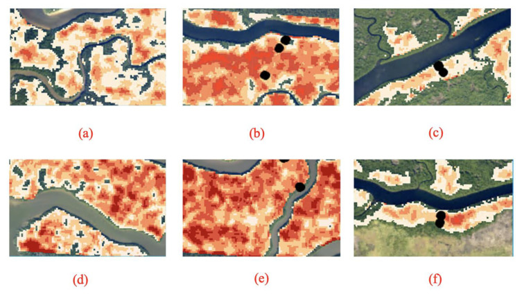
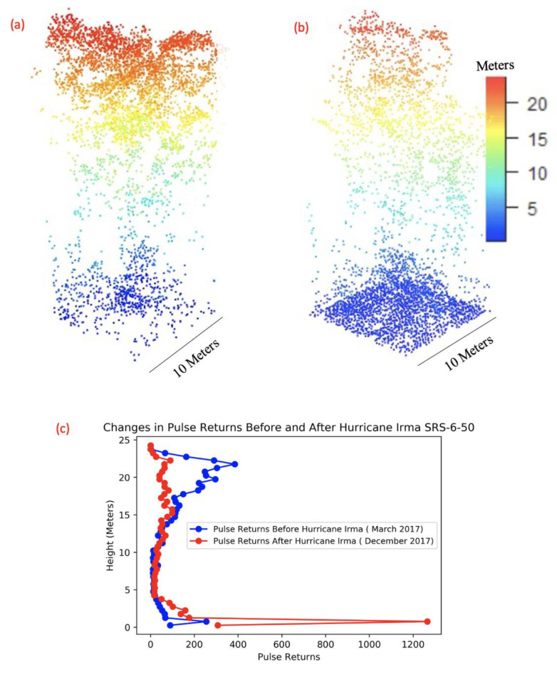
In September 2017, Hurricane Irma made landfall in South Florida, causing a great deal of damage to mangrove forests along the southwest coast. A combination of hurricane strength winds and high storm surge across the area resulted in canopy defoliation, broken branches, and downed trees. Evaluating changes in mangrove forest structure is significant, as a loss or change in mangrove forest structure can lead to loss in the ecosystems services that they provide. In this study, we used lidar remote sensing technology and field data to assess damage to the South Florida mangrove forests from Hurricane Irma. Lidar data provided an opportunity to investigate changes in mangrove forests using 3D high-resolution data to assess hurricane-induced changes at different tree structure levels. Using lidar data in conjunction with field observations, we were able to model aboveground necromass (AGN; standing dead trees) on a regional scale across the Shark River and Harney River within Everglades National Park. AGN estimates were higher in the mouth and downstream section of Shark River and higher in the downstream section of the Harney River, with higher impact observed in Shark River. Mean AGN estimates were 46 Mg/ha in Shark River and 38 Mg/ha in Harney River and an average loss of 29% in biomass, showing a significant damage when compared to other areas impacted by Hurricane Irma and previous disturbances in our study region.

摘要

2017 年 9 月,飓风“艾尔玛”在南佛罗里达州登陆,对该州西南部沿海的红树林造成了巨大破坏。该地区狂风和风暴潮的双重打击导致树冠落叶、树枝折断和树木倒伏。评估红树林森林结构的变化意义重大,因为红树林森林结构的损失或变化可能导致其提供的生态系统服务的丧失。在这项研究中,我们使用激光雷达遥感技术和实地数据来评估飓风“艾尔玛”对南佛罗里达州红树林的破坏。激光雷达数据提供了一个机会,可以利用 3D 高分辨率数据来调查红树林的变化,从而评估不同树木结构水平的飓风引发的变化。通过将激光雷达数据与实地观测相结合,我们能够在鲨鱼河和哈雷河的埃弗格莱兹国家公园内的区域范围内对地上枯木(AGN;立枯树)进行建模。鲨鱼河河口和下游段的 AGN 估计值较高,哈雷河下游段的 AGN 估计值也较高,鲨鱼河受到的影响更大。鲨鱼河的平均 AGN 估计值为 46 Mg/ha,哈雷河的平均 AGN 估计值为 38 Mg/ha,生物量平均损失 29%,与我们研究区域内受飓风“艾尔玛”和以前干扰影响的其他地区相比,这表明破坏非常严重。

https://cdn.ncbi.nlm.nih.gov/pmc/blobs/31e4/10422621/c256d9390592/sensors-23-06669-g007.jpg
https://cdn.ncbi.nlm.nih.gov/pmc/blobs/31e4/10422621/34cbf443d0df/sensors-23-06669-g001.jpg
https://cdn.ncbi.nlm.nih.gov/pmc/blobs/31e4/10422621/bf77fc25ad5a/sensors-23-06669-g003.jpg
https://cdn.ncbi.nlm.nih.gov/pmc/blobs/31e4/10422621/666361103a2b/sensors-23-06669-g005.jpg
https://cdn.ncbi.nlm.nih.gov/pmc/blobs/31e4/10422621/c256d9390592/sensors-23-06669-g007.jpg

相似文献

1
Estimating Structural Damage to Mangrove Forests Using Airborne Lidar Imagery: Case Study of Damage Induced by the 2017 Hurricane Irma to Mangroves in the Florida Everglades, USA.利用机载激光雷达图像估算红树林的结构损坏:以美国佛罗里达州大沼泽地 2017 年飓风“艾尔玛”对红树林造成的破坏为例。
Sensors (Basel). 2023 Jul 25;23(15):6669. doi: 10.3390/s23156669.
2
Storm surge and ponding explain mangrove dieback in southwest Florida following Hurricane Irma.风暴潮和积水解释了佛罗里达西南部在飓风“艾玛”过后红树林的衰退。
Nat Commun. 2021 Jun 28;12(1):4003. doi: 10.1038/s41467-021-24253-y.
3
Airborne Laser Scanning Quantification of Disturbances from Hurricanes and Lightning Strikes to Mangrove Forests in Everglades National Park, USA.美国大沼泽地国家公园中飓风和雷击对红树林造成干扰的机载激光扫描量化分析
Sensors (Basel). 2008 Apr 1;8(4):2262-2292. doi: 10.3390/s8042262.
4
Estimating the Effects of a Hurricane on Carbon Storage in Mangrove Wetlands in Southwest Florida.估算飓风对佛罗里达州西南部红树林湿地碳储存的影响。
Plants (Basel). 2021 Aug 23;10(8):1749. doi: 10.3390/plants10081749.
5
Nutrient enrichment intensifies hurricane impact in scrub mangrove ecosystems in the Indian River Lagoon, Florida, USA.营养物质富集加剧了美国佛罗里达州印度河泻湖灌丛红树林生态系统中飓风的影响。
Ecology. 2015 Nov;96(11):2960-72. doi: 10.1890/14-1853.1.
6
Monitoring detailed mangrove hurricane damage and early recovery using multisource remote sensing data.利用多源遥感数据监测详细的红树林飓风损害和早期恢复。
J Environ Manage. 2022 Oct 15;320:115830. doi: 10.1016/j.jenvman.2022.115830. Epub 2022 Aug 6.
7
Hurricanes fertilize mangrove forests in the Gulf of Mexico (Florida Everglades, USA).飓风使墨西哥湾(美国佛罗里达州大沼泽地)的红树林得到滋养。
Proc Natl Acad Sci U S A. 2020 Mar 3;117(9):4831-4841. doi: 10.1073/pnas.1908597117. Epub 2020 Feb 18.
8
Dynamics of marsh-mangrove ecotone since the mid-Holocene: A palynological study of mangrove encroachment and sea level rise in the Shark River Estuary, Florida.全新世中期以来的沼泽-红树林交错带动态:佛罗里达州鲨鱼河口红树林入侵与海平面上升的孢粉学研究
PLoS One. 2017 Mar 10;12(3):e0173670. doi: 10.1371/journal.pone.0173670. eCollection 2017.
9
The Impact of Hurricane Irma on Population Density of the Black Salt-Marsh Mosquito, , in Collier County, Florida.飓风艾尔玛对佛罗里达州科利尔县黑盐沼蚊种群密度的影响
J Am Mosq Control Assoc. 2019 Mar;35(1):71-74. doi: 10.2987/18-6793.1.
10
Long-term structural and biomass dynamics of virgin Tsuga canadensis-Pinus strobus forests after hurricane disturbance.飓风干扰后原始的加拿大铁杉-火炬松森林的长期结构和生物量动态。
Ecology. 2017 Mar;98(3):721-733. doi: 10.1002/ecy.1684. Epub 2017 Feb 3.

引用本文的文献

1
Aboveground biomass density maps for post-hurricane Ian forest monitoring in Florida.用于佛罗里达州飓风伊恩过后森林监测的地上生物量密度图。
Sci Data. 2025 Jul 10;12(1):1189. doi: 10.1038/s41597-025-05464-0.
2
Resilience to Hurricanes Is High in Mangrove Blue Carbon Forests.红树林蓝碳森林对飓风的恢复力很强。
Glob Chang Biol. 2025 Mar;31(3):e70124. doi: 10.1111/gcb.70124.

本文引用的文献

1
Storm surge and ponding explain mangrove dieback in southwest Florida following Hurricane Irma.风暴潮和积水解释了佛罗里达西南部在飓风“艾玛”过后红树林的衰退。
Nat Commun. 2021 Jun 28;12(1):4003. doi: 10.1038/s41467-021-24253-y.
2
Global declines in human-driven mangrove loss.全球人为导致的红树林损失减少。
Glob Chang Biol. 2020 Oct;26(10):5844-5855. doi: 10.1111/gcb.15275. Epub 2020 Aug 3.
3
The Global Flood Protection Benefits of Mangroves.红树林的全球防洪效益。
Sci Rep. 2020 Mar 10;10(1):4404. doi: 10.1038/s41598-020-61136-6.
4
Hurricanes fertilize mangrove forests in the Gulf of Mexico (Florida Everglades, USA).飓风使墨西哥湾(美国佛罗里达州大沼泽地)的红树林得到滋养。
Proc Natl Acad Sci U S A. 2020 Mar 3;117(9):4831-4841. doi: 10.1073/pnas.1908597117. Epub 2020 Feb 18.
5
Mangroves shelter coastal economic activity from cyclones.红树林为沿海经济活动提供了抵御旋风的庇护。
Proc Natl Acad Sci U S A. 2019 Jun 18;116(25):12232-12237. doi: 10.1073/pnas.1820067116. Epub 2019 Jun 3.
6
Airborne Laser Scanning Quantification of Disturbances from Hurricanes and Lightning Strikes to Mangrove Forests in Everglades National Park, USA.美国大沼泽地国家公园中飓风和雷击对红树林造成干扰的机载激光扫描量化分析
Sensors (Basel). 2008 Apr 1;8(4):2262-2292. doi: 10.3390/s8042262.