• 文献检索
  • 文档翻译
  • 深度研究
  • 学术资讯
  • Suppr Zotero 插件Zotero 插件
  • 邀请有礼
  • 套餐&价格
  • 历史记录
应用&插件
Suppr Zotero 插件Zotero 插件浏览器插件Mac 客户端Windows 客户端微信小程序
定价
高级版会员购买积分包购买API积分包
服务
文献检索文档翻译深度研究API 文档MCP 服务
关于我们
关于 Suppr公司介绍联系我们用户协议隐私条款
关注我们

Suppr 超能文献

核心技术专利:CN118964589B侵权必究
粤ICP备2023148730 号-1Suppr @ 2026

文献检索

告别复杂PubMed语法,用中文像聊天一样搜索,搜遍4000万医学文献。AI智能推荐,让科研检索更轻松。

立即免费搜索

文件翻译

保留排版,准确专业,支持PDF/Word/PPT等文件格式,支持 12+语言互译。

免费翻译文档

深度研究

AI帮你快速写综述,25分钟生成高质量综述,智能提取关键信息,辅助科研写作。

立即免费体验

利用多颗 MODIS 卫星数据研究埃塞俄比亚西部土地利用/土地覆盖和植被的时空变化。

Spatio-Temporal Change of Land Use/Land Cover and Vegetation Using Multi-MODIS Satellite Data, Western Ethiopia.

机构信息

Haramaya Institute of Technology, Haramaya University, P.O. Box 138, Dire Dawa, Ethiopia.

Ethiopian Institute of Water Resources, Addis Ababa University, P.O. Box 1176, Addis Ababa, Ethiopia.

出版信息

ScientificWorldJournal. 2023 Oct 31;2023:7454137. doi: 10.1155/2023/7454137. eCollection 2023.

DOI:10.1155/2023/7454137
PMID:37942016
原文链接:https://pmc.ncbi.nlm.nih.gov/articles/PMC10630015/
Abstract

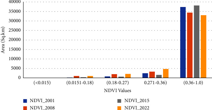
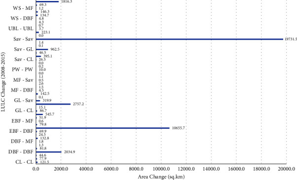
Land use and land cover (LULC) change and variability are some of the challenges to present-day water resource management. The purpose of this study was to determine LULC and Normalized Difference Vegetation Index (NDVI) fluctuations in western Ethiopia during the last 20 years. The first part of the study used MODIS LULC data for the change analysis, change detection, and spatial and temporal coverage in the study region. In the second part, the study analyzes the NDVI change and its spatial and temporal coverage. In this study, The Moderate Resolution Imaging Spectroradiometer (MODIS) satellite data were applied to determine LULC and NDVI changes over four different periods. Evergreen broadleaf forests, deciduous broadleaf forests, mixed forests, woody savannas, savannas, grasslands, permanent wetlands, croplands, urban and built-up lands, and water bodies are the LULC in the period of analysis. The overall classification accuracy for the classified image from 2001 to 2020 was 85.4% and the overall kappa statistic was 81.2%. The results indicate a substantial increase in woody savannas, deciduous broadleaf, grasslands, permanent wetlands, and mixed forest areas by 119.6%, 57.7% 45.2%, 37%, and 21.3%, respectively, followed by reductions in croplands, water bodies, savannas, and evergreen broadleaf forest by 90.1%, 19.8%, 13.2%, and 4.8%, respectively, for the catchment between 2001 and 2020. The result also showed that the area's vegetation cover increased by 64% from 2001 to 2022. This study could provide valuable information for water resource and environmental management as well as policy and decision-making.

摘要

土地利用和土地覆被(LULC)变化和变异性是当今水资源管理面临的一些挑战。本研究旨在确定过去 20 年埃塞俄比亚西部的 LULC 和归一化植被指数(NDVI)波动情况。研究的第一部分使用 MODIS LULC 数据进行变化分析、变化检测以及研究区域的时空覆盖分析。在第二部分,研究分析了 NDVI 变化及其时空覆盖情况。在本研究中,应用中分辨率成像光谱仪(MODIS)卫星数据确定了四个不同时期的 LULC 和 NDVI 变化。常绿阔叶林、落叶阔叶林、混交林、木本稀树草原、稀树草原、草地、永久性湿地、耕地、城市和建成区以及水体是分析期内的 LULC。2001 年至 2020 年分类图像的总体分类精度为 85.4%,总体kappa 统计量为 81.2%。结果表明,木本稀树草原、落叶阔叶林、草地、永久性湿地和混交林面积分别显著增加了 119.6%、57.7%、45.2%、37%和 21.3%,而耕地、水体、稀树草原和常绿阔叶林面积分别减少了 90.1%、19.8%、13.2%和 4.8%,在 2001 年至 2020 年期间,流域面积减少了 90.1%、19.8%、13.2%和 4.8%。结果还表明,该地区的植被覆盖面积从 2001 年到 2022 年增加了 64%。本研究可为水资源和环境管理以及政策和决策提供有价值的信息。

https://cdn.ncbi.nlm.nih.gov/pmc/blobs/0216/10630015/46305d8f6b72/TSWJ2023-7454137.014.jpg
https://cdn.ncbi.nlm.nih.gov/pmc/blobs/0216/10630015/69682ec78999/TSWJ2023-7454137.001.jpg
https://cdn.ncbi.nlm.nih.gov/pmc/blobs/0216/10630015/6d4a62acc6db/TSWJ2023-7454137.002.jpg
https://cdn.ncbi.nlm.nih.gov/pmc/blobs/0216/10630015/6f96ba37c238/TSWJ2023-7454137.003.jpg
https://cdn.ncbi.nlm.nih.gov/pmc/blobs/0216/10630015/c0696147e2a9/TSWJ2023-7454137.004.jpg
https://cdn.ncbi.nlm.nih.gov/pmc/blobs/0216/10630015/d4b402a079df/TSWJ2023-7454137.005.jpg
https://cdn.ncbi.nlm.nih.gov/pmc/blobs/0216/10630015/c61e99af92d1/TSWJ2023-7454137.006.jpg
https://cdn.ncbi.nlm.nih.gov/pmc/blobs/0216/10630015/8457525de9c7/TSWJ2023-7454137.007.jpg
https://cdn.ncbi.nlm.nih.gov/pmc/blobs/0216/10630015/e625eec0d231/TSWJ2023-7454137.008.jpg
https://cdn.ncbi.nlm.nih.gov/pmc/blobs/0216/10630015/9a3ae98842d1/TSWJ2023-7454137.009.jpg
https://cdn.ncbi.nlm.nih.gov/pmc/blobs/0216/10630015/ec39b229a4e3/TSWJ2023-7454137.010.jpg
https://cdn.ncbi.nlm.nih.gov/pmc/blobs/0216/10630015/9e936566ec8f/TSWJ2023-7454137.011.jpg
https://cdn.ncbi.nlm.nih.gov/pmc/blobs/0216/10630015/9dfe9621058f/TSWJ2023-7454137.012.jpg
https://cdn.ncbi.nlm.nih.gov/pmc/blobs/0216/10630015/030af8843bf3/TSWJ2023-7454137.013.jpg
https://cdn.ncbi.nlm.nih.gov/pmc/blobs/0216/10630015/46305d8f6b72/TSWJ2023-7454137.014.jpg

相似文献

1
Spatio-Temporal Change of Land Use/Land Cover and Vegetation Using Multi-MODIS Satellite Data, Western Ethiopia.利用多颗 MODIS 卫星数据研究埃塞俄比亚西部土地利用/土地覆盖和植被的时空变化。
ScientificWorldJournal. 2023 Oct 31;2023:7454137. doi: 10.1155/2023/7454137. eCollection 2023.
2
A time series of land cover maps of South Asia from 2001 to 2015 generated using AVHRR GIMMS NDVI3g data.利用 AVHRR GIMMS NDVI3g 数据生成的 2001 年至 2015 年南亚土地覆盖物时间序列地图。
Environ Sci Pollut Res Int. 2020 Jun;27(16):20309-20320. doi: 10.1007/s11356-020-08433-9. Epub 2020 Apr 2.
3
Remote sensing strategies to monitoring land use maps with AVHRR and MODIS data over the South Asia regions.利用 AVHRR 和 MODIS 数据进行遥感监测南亚地区土地利用图的策略。
Environ Sci Pollut Res Int. 2023 Mar;30(11):31741-31754. doi: 10.1007/s11356-022-24401-x. Epub 2022 Dec 1.
4
Analysis of the spatiotemporal changes in global land cover from 2001 to 2020.2001年至2020年全球土地覆盖的时空变化分析。
Sci Total Environ. 2024 Jan 15;908:168354. doi: 10.1016/j.scitotenv.2023.168354. Epub 2023 Nov 5.
5
[Comparison of GIMMS and MODIS normalized vegetation index composite data for Qing-Hai-Tibet Plateau].[青藏高原GIMMS和MODIS归一化植被指数合成数据比较]
Ying Yong Sheng Tai Xue Bao. 2014 Feb;25(2):533-44.
6
GIS based mapping of land cover changes utilizing multi-temporal remotely sensed image data in Lake Hawassa Watershed, Ethiopia.基于 GIS 的埃塞俄比亚 Hawassa 流域利用多时相遥感影像数据的土地覆盖变化制图。
Environ Monit Assess. 2014 Mar;186(3):1765-80. doi: 10.1007/s10661-013-3491-x. Epub 2013 Dec 6.
7
Land use and land cover dynamics and ecosystem services values in Kewet district in the central dry lowlands of Ethiopia.埃塞俄比亚中部干旱低地 Kewet 区的土地利用/土地覆被动态与生态系统服务价值
Environ Monit Assess. 2022 Sep 19;194(11):801. doi: 10.1007/s10661-022-10486-x.
8
Analyses of LULC dynamics in a socio-ecological system of the Bale Mountains Eco Region of Southeast Ethiopia.分析埃塞俄比亚东南部 Bale 山脉生态区社会-生态系统的土地利用/土地覆被动态变化。
Environ Monit Assess. 2024 Jun 21;196(7):644. doi: 10.1007/s10661-024-12671-6.
9
Monitoring land cover change detection with NOAA-AVHRR and MODIS remotely sensed data in the North and West of Africa from 1982 to 2015.利用 1982 年至 2015 年期间的 NOAA-AVHRR 和 MODIS 遥感数据监测北非和西非的土地覆盖变化检测。
Environ Sci Pollut Res Int. 2020 Feb;27(6):5873-5889. doi: 10.1007/s11356-019-07216-1. Epub 2019 Dec 20.
10
Investigating the interplay between urban dynamics and environmental factors in Thimphu, Bhutan: a satellite remote sensing approach.探讨不丹廷布市的城市动态与环境因素之间的相互作用:卫星遥感方法。
Environ Monit Assess. 2024 Jul 6;196(8):706. doi: 10.1007/s10661-024-12882-x.

引用本文的文献

1
Analyzing Land Use/Land Cover Changes Using Google Earth Engine and Random Forest Algorithm and Their Implications to the Management of Land Degradation in the Upper Tekeze Basin, Ethiopia.利用谷歌地球引擎和随机森林算法分析埃塞俄比亚上特克泽河流域的土地利用/土地覆盖变化及其对土地退化管理的影响
ScientificWorldJournal. 2024 Jul 30;2024:3937558. doi: 10.1155/2024/3937558. eCollection 2024.

本文引用的文献

1
Regional thermal environment changes: Integration of satellite data and land use/land cover.区域热环境变化:卫星数据与土地利用/土地覆盖的整合
iScience. 2022 Dec 17;26(2):105820. doi: 10.1016/j.isci.2022.105820. eCollection 2023 Feb 17.
2
The impact of land use and land cover changes on the landscape pattern and ecosystem service value in Sanjiangyuan region of the Qinghai-Tibet Plateau.青藏高原三江源地区土地利用/土地覆被变化对景观格局和生态系统服务价值的影响。
J Environ Manage. 2023 Jan 1;325(Pt B):116539. doi: 10.1016/j.jenvman.2022.116539. Epub 2022 Oct 20.
3
Habitat quality dynamics in China's first group of national parks in recent four decades: Evidence from land use and land cover changes.
近四十年中国首批国家公园的生境质量动态:基于土地利用和土地覆被变化的证据。
J Environ Manage. 2023 Jan 1;325(Pt A):116505. doi: 10.1016/j.jenvman.2022.116505. Epub 2022 Oct 18.
4
Analysis of the Current and Future Prediction of Land Use/Land Cover Change Using Remote Sensing and the CA-Markov Model in Majang Forest Biosphere Reserves of Gambella, Southwestern Ethiopia.利用遥感和 CA-Markov 模型分析埃塞俄比亚西南部马江森林生物圈保护区土地利用/土地覆盖变化的现状和未来预测。
ScientificWorldJournal. 2021 Feb 23;2021:6685045. doi: 10.1155/2021/6685045. eCollection 2021.
5
Survey on Land Use/Land Cover (LU/LC) change analysis in remote sensing and GIS environment: Techniques and Challenges.遥感和 GIS 环境下土地利用/土地覆盖(LU/LC)变化分析调查:技术与挑战。
Environ Sci Pollut Res Int. 2020 Aug;27(24):29900-29926. doi: 10.1007/s11356-020-09091-7. Epub 2020 Jun 5.
6
Using the satellite-derived NDVI to assess ecological responses to environmental change.利用卫星遥感归一化植被指数评估生态系统对环境变化的响应。
Trends Ecol Evol. 2005 Sep;20(9):503-10. doi: 10.1016/j.tree.2005.05.011. Epub 2005 Jun 9.