School of Epidemiology and Public Health, Faculty of Medicine, University of Ottawa, Ottawa, ON, Canada.
Westmead Applied Research Centre, Faculty of Medicine & Health, The University of Sydney, Westmead, NSW, Australia.
Lancet Glob Health. 2024 Nov;12(11):e1794-e1806. doi: 10.1016/S2214-109X(24)00287-0. Epub 2024 Sep 27.
The built environment can influence human health, but the available evidence is modest and almost entirely from urban communities in high-income countries. Here we aimed to analyse built environment characteristics and their associations with obesity in urban and rural communities in 21 countries at different development levels participating in the Prospective Urban and Rural Epidemiology (PURE) Study.
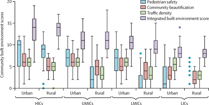
Photographs were acquired with a standardised approach. We used the previously validated Environmental Profile of a Community's Health photo instrument to evaluate photos for safety, walkability, neighbourhood beautification, and community disorder. An integrated built environment score (ie, a minimum of 0 and a maximum of 20) was used to summarise this evaluation across built environment domains. Associations between built environment characteristics, separately and combined in the integrated built environment score, and obesity (ie, a BMI >30kg/m) were assessed using multilevel regression models, adjusting for individual, household, and community confounding factors. Attenuation in the associations due to walking was examined.
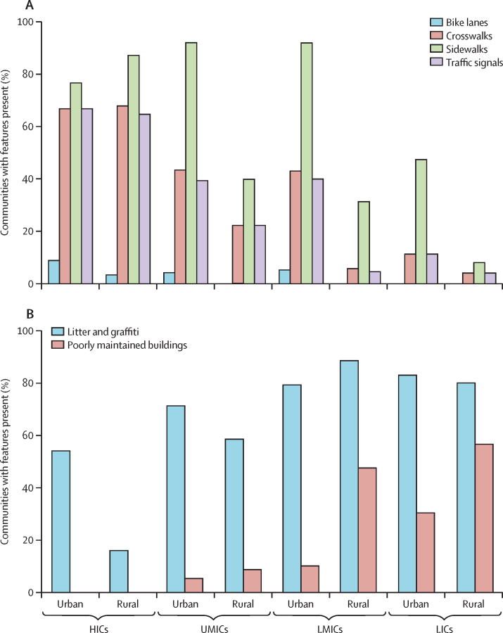
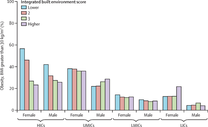
Analyses include 143 338 participants from 530 communities. The mean integrated built environment score was higher in high-income countries (13·3, SD 2·8) compared with other regions (10·1, 2·5) and urban communities (11·2, 3·0). More than 60% of high-income country communities had pedestrian safety features (eg, crosswalks, sidewalks, and traffic signals). Urban communities outside high-income countries had higher rates of sidewalks (176 [84%] of 209) than rural communities (59 [28%] of 209). 15 (5%) of 290 urban communities had bike lanes. Litter and graffiti were present in 372 (70%) of 530 communities, and poorly maintained buildings were present in 103 (19%) of 530. The integrated built environment score was significantly associated with reduced obesity overall (relative risk [RR] 0·58, 95% CI 0·35-0·93; p=0·025) for high compared with low scores and for increasing trend (0·85, 0·78-0·91; p<0·0001). The trends were statistically significant in urban (0·85, 0·77-0·93; p=0·0007) and rural (0·87, 0·78-0·97; p=0·015) communities. Some built environment features were associated with a lower prevalence of obesity: community beautification RR 0·75 (95% CI 0·61-0·92; p=0·0066); bike lanes RR 0·58 (0·45-0·73; p<0·0001); pedestrian safety RR 0·75 (0·62-0·90; p=0·0018); and traffic signals RR 0·68 (0·52-0·89; p=0·0055). Community disorder was associated with a higher prevalence of obesity (RR 1·48, 95% CI 1·17-1·86; p=0·0010).
Community built environment features recorded in photographs, including bike lanes, pedestrian safety measures, beautification, traffic density, and disorder, were related to obesity after adjusting for confounders, and stronger associations were found in urban than rural communities. The method presents a novel way of assessing the built environment's potential effect on health.
Population Health Research Institute, Hamilton Health Sciences Research Institute, Heart and Stroke Foundation of Ontario, Canadian Institutes of Health Research's Strategy for Patient Oriented Research, Ontario Support Unit, Ontario Ministry of Health and Long-Term Care, AstraZeneca, Sanofi-Aventis, Boehringer Ingelheim, Servier, and GlaxoSmithKline.
建筑环境会影响人类健康,但现有证据有限,且几乎全部来自高收入国家的城市社区。本研究旨在分析 21 个不同发展水平国家的城市和农村社区的建筑环境特征及其与肥胖的关系,这些国家均参与了前瞻性城乡流行病学(PURE)研究。
采用标准化方法采集照片。我们使用先前验证过的社区健康环境照片评估工具(Environmental Profile of a Community's Health photo instrument)评估照片的安全性、可步行性、邻里美化和社区混乱程度。使用综合建筑环境评分(即最低 0 分,最高 20 分)综合评估建筑环境领域的评估结果。使用多水平回归模型评估肥胖(即 BMI>30kg/m2)与建筑环境特征(单独评估和整合到综合建筑环境评分中)之间的关联,并调整个体、家庭和社区混杂因素。还检查了因步行而导致关联减弱的情况。
分析纳入了来自 530 个社区的 143338 名参与者。高收入国家的综合建筑环境评分均值(13.3,标准差 2.8)高于其他地区(10.1,2.5)和城市社区(11.2,3.0)。超过 60%的高收入国家社区设有行人安全设施(如横道线、人行道和交通信号)。与农村社区(59%,209 个中的 119 个)相比,高收入国家以外的城市社区的人行道比例更高(84%,209 个中的 176 个)。290 个城市社区中有 15 个(5%)设有自行车道。372 个社区(70%)存在垃圾和涂鸦,103 个社区(19%)存在维护不善的建筑物。综合建筑环境评分与肥胖的发生显著相关(与低评分相比,相对风险 [RR]0.58,95%CI0.35-0.93;p=0.025),且呈递增趋势(0.85,0.78-0.91;p<0.0001)。该趋势在城市(0.85,0.77-0.93;p=0.0007)和农村社区(0.87,0.78-0.97;p=0.015)中均具有统计学意义。一些建筑环境特征与肥胖的患病率较低有关:社区美化 RR0.75(95%CI0.61-0.92;p=0.0066);自行车道 RR0.58(0.45-0.73;p<0.0001);行人安全 RR0.75(0.62-0.90;p=0.0018);和交通信号 RR0.68(0.52-0.89;p=0.0055)。社区混乱与肥胖的患病率较高有关(RR1.48,95%CI1.17-1.86;p=0.0010)。
经混杂因素调整后,照片中记录的社区建筑环境特征(包括自行车道、行人安全措施、美化、交通密度和混乱程度)与肥胖有关,且在城市社区中的关联更强。该方法为评估建筑环境对健康的潜在影响提供了一种新颖的方法。
人口健康研究所以及汉密尔顿健康科学研究所、加拿大心脏和中风基金会、安大略省患者导向研究战略、安大略省支持单位、安大略省卫生部和长期护理部、阿斯利康、赛诺菲-安万特、勃林格殷格翰、施维雅和葛兰素史克。