Ross C Wade, Loudermilk E Louise, O'Brien Joseph J, Snitker Grant
Tall Timbers, 13093 Henry Beadel Dr, Tallahassee, FL 32312, United States.
US Forest Service, Southern Research Station, 320 E Green St, Athens, GA 30602, United States.
Data Brief. 2024 Sep 18;57:110955. doi: 10.1016/j.dib.2024.110955. eCollection 2024 Dec.
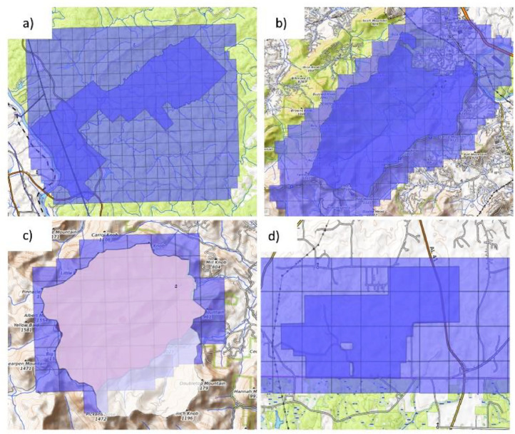
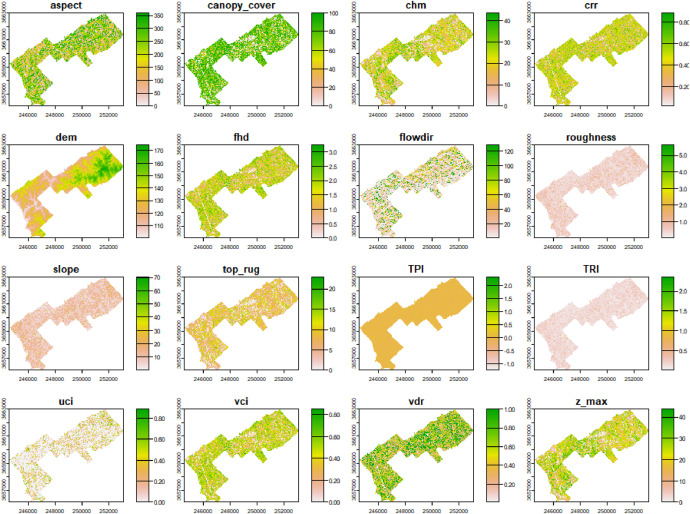
Structural complexity refers to the three-dimensional arrangement and variability of both biotic and abiotic components of an ecosystem. Metrics that characterize structural complexity are often used to manage various aspects of ecosystem function, such as light transmittance, wildlife habitat, and biological diversity. Additionally, these metrics aid in evaluating resilience to disturbance events, including hurricanes, bark-beetle outbreaks, and wildfire. Recent advances in wildland fire modelling have facilitated the integration of forest structural complexity metrics into the QUIC-Fire model, enabling real-time prediction of fire spread and behaviour by simulating interactions between fire, weather, topography, and forest structure. While QUIC-Fire is designed to be highly adaptable, model performance depends on the availability and accuracy of local data inputs. Expanding the model's usability across different regions can be facilitated by the availability of more comprehensive and high-quality data. Thus, the primary goal behind the data products we developed was to establish a basis for collaborative research across various disciplines, particularly within the focal areas of the Southern Research Station, such as forestry, wildland fire, hydrology, soil science, and cultural resources at Bent Creek, Coweeta, Escambia, and Hitchiti Experimental Forests (EFs). Airborne laser scanning (ALS) was used to collect point-cloud data for each EF during the leaf-off season to minimize interference from foliage. Subsequent processing of the raw lidar data involved outlier detection and filtering, ground and non-ground classification, and the computation of a variety of metrics representing various aspects of topography and forest structure at both the pixel-level and the tree-level. Pixel-level topographic data products include: digital elevation model (DEM), slope, aspect, topographic position index (TPI), topographic roughness index (TRI), roughness, and flow direction. Forest structural-complexity metrics include canopy height, foliar height diversity (FHD), vertical distribution ratio (VDR), canopy rugosity, crown relief ratio (CRR), understory complexity index (UCI), vertical complexity index (VCI), canopy cover, mean vegetation height, and the standard deviation of vegetation height. Tree-level data products were computed from the point cloud using multiple algorithms to perform individual tree detection (ITD) and individual tree segmentation (ITS). The datasets have been harmonized and are openly accessible through the USDA Forest Service Research Data Archive.
结构复杂性指的是生态系统中生物和非生物成分的三维排列及变异性。用于描述结构复杂性的指标常被用于管理生态系统功能的各个方面,如光透射率、野生动物栖息地和生物多样性。此外,这些指标有助于评估对干扰事件的恢复力,包括飓风、树皮甲虫爆发和野火。野地火灾建模的最新进展促进了森林结构复杂性指标与QUIC - Fire模型的整合,通过模拟火灾、天气、地形和森林结构之间的相互作用,实现对火灾蔓延和行为的实时预测。虽然QUIC - Fire设计得具有高度适应性,但模型性能取决于本地数据输入的可用性和准确性。更全面、高质量数据的可用性有助于扩大该模型在不同地区的适用性。因此,我们开发的数据产品背后的主要目标是为跨学科合作研究奠定基础,特别是在南方研究站的重点领域内,如本特克里克、考伊塔、埃斯坎比亚和希奇蒂实验林(EFs)的林业、野地火灾、水文、土壤科学和文化资源等领域。在落叶季节使用机载激光扫描(ALS)为每个实验林收集点云数据,以尽量减少树叶的干扰。原始激光雷达数据的后续处理包括异常值检测和滤波、地面和非地面分类,以及在像素级和树级计算代表地形和森林结构各个方面的各种指标。像素级地形数据产品包括:数字高程模型(DEM)、坡度、坡向、地形位置指数(TPI)、地形粗糙度指数(TRI)、粗糙度和水流方向。森林结构复杂性指标包括树冠高度、叶高多样性(FHD)、垂直分布比(VDR)、树冠粗糙度、树冠起伏比(CRR)、林下复杂性指数(UCI)、垂直复杂性指数(VCI)、树冠覆盖率、平均植被高度和植被高度标准差。使用多种算法从点云计算树级数据产品,以执行单木检测(ITD)和单木分割(ITS)。这些数据集已经过协调,并可通过美国农业部森林服务研究数据存档公开获取。