Dalponte Michele, Coomes David A
Department of Sustainable Agro-ecosystems and Bioresources Research and Innovation Centre Fondazione E. Mach Via E. Mach 138010 San Michele all'Adige (TN) Italy; Forest Ecology and Conservation Group Department of Plant Sciences University of Cambridge Downing Street Cambridge CB2 3EA UK.
Forest Ecology and Conservation Group Department of Plant Sciences University of Cambridge Downing Street Cambridge CB2 3EA UK.
Methods Ecol Evol. 2016 Oct;7(10):1236-1245. doi: 10.1111/2041-210X.12575. Epub 2016 May 14.
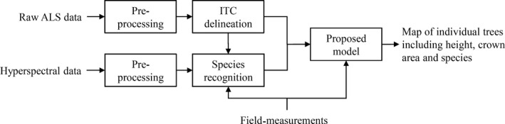
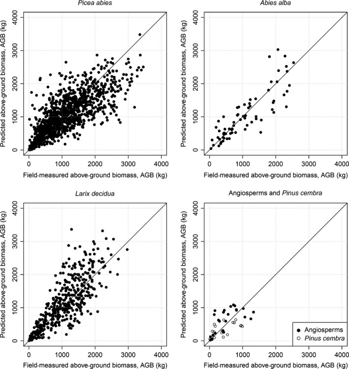
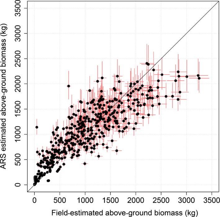
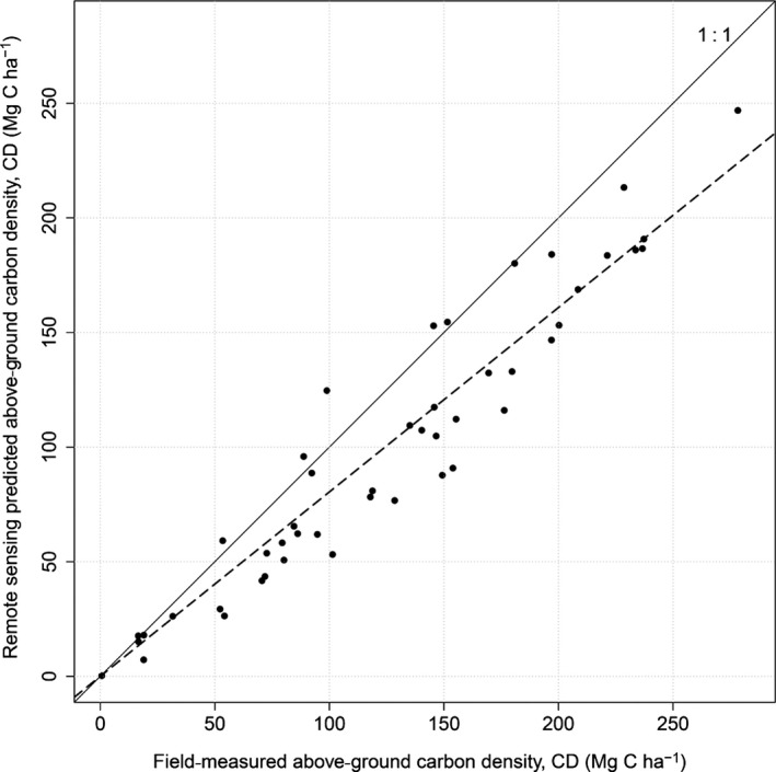
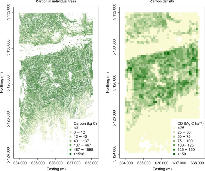
Forests are a major component of the global carbon cycle, and accurate estimation of forest carbon stocks and fluxes is important in the context of anthropogenic global change. Airborne laser scanning (ALS) data sets are increasingly recognized as outstanding data sources for high-fidelity mapping of carbon stocks at regional scales.We develop a tree-centric approach to carbon mapping, based on identifying individual tree crowns (ITCs) and species from airborne remote sensing data, from which individual tree carbon stocks are calculated. We identify ITCs from the laser scanning point cloud using a region-growing algorithm and identifying species from airborne hyperspectral data by machine learning. For each detected tree, we predict stem diameter from its height and crown-width estimate. From that point on, we use well-established approaches developed for field-based inventories: above-ground biomasses of trees are estimated using published allometries and summed within plots to estimate carbon density.We show this approach is highly reliable: tests in the Italian Alps demonstrated a close relationship between field- and ALS-based estimates of carbon stocks ( = 0·98). Small trees are invisible from the air, and a correction factor is required to accommodate this effect.An advantage of the tree-centric approach over existing area-based methods is that it can produce maps at any scale and is fundamentally based on field-based inventory methods, making it intuitive and transparent. Airborne laser scanning, hyperspectral sensing and computational power are all advancing rapidly, making it increasingly feasible to use ITC approaches for effective mapping of forest carbon density also inside wider carbon mapping programs like REDD++.
森林是全球碳循环的主要组成部分,在人为全球变化的背景下,准确估算森林碳储量和通量至关重要。机载激光扫描(ALS)数据集越来越被视为区域尺度上高保真绘制碳储量的优秀数据源。我们开发了一种以树木为中心的碳绘图方法,该方法基于从机载遥感数据中识别单个树冠(ITC)和树种,进而计算单个树木的碳储量。我们使用区域生长算法从激光扫描点云中识别ITC,并通过机器学习从机载高光谱数据中识别树种。对于每棵检测到的树木,我们根据其高度和树冠宽度估计值预测树干直径。从那时起,我们使用为实地清查开发的成熟方法:利用已发表的生物量换算公式估算树木的地上生物量,并在样地内求和以估算碳密度。我们表明这种方法高度可靠:在意大利阿尔卑斯山的测试表明,基于实地和基于ALS的碳储量估计之间存在密切关系(r = 0·98)。小树木从空中不可见,需要一个校正因子来适应这种影响。以树木为中心的方法相对于现有基于面积的方法的一个优点是,它可以在任何尺度上生成地图,并且从根本上基于实地清查方法,使其直观且透明。机载激光扫描、高光谱传感和计算能力都在迅速发展,使得在更广泛的碳绘图计划(如REDD++)中使用ITC方法有效绘制森林碳密度变得越来越可行。