• 文献检索
  • 文档翻译
  • 深度研究
  • 学术资讯
  • Suppr Zotero 插件Zotero 插件
  • 邀请有礼
  • 套餐&价格
  • 历史记录
应用&插件
Suppr Zotero 插件Zotero 插件浏览器插件Mac 客户端Windows 客户端微信小程序
定价
高级版会员购买积分包购买API积分包
服务
文献检索文档翻译深度研究API 文档MCP 服务
关于我们
关于 Suppr公司介绍联系我们用户协议隐私条款
关注我们

Suppr 超能文献

核心技术专利:CN118964589B侵权必究
粤ICP备2023148730 号-1Suppr @ 2026

文献检索

告别复杂PubMed语法,用中文像聊天一样搜索,搜遍4000万医学文献。AI智能推荐,让科研检索更轻松。

立即免费搜索

文件翻译

保留排版,准确专业,支持PDF/Word/PPT等文件格式,支持 12+语言互译。

免费翻译文档

深度研究

AI帮你快速写综述,25分钟生成高质量综述,智能提取关键信息,辅助科研写作。

立即免费体验

NEON-SD:一种源自NEON离散回波激光雷达点云的30米结构多样性产物。

NEON-SD: A 30-m Structural Diversity Product Derived from the NEON Discrete-Return LiDAR Point Cloud.

作者信息

Wang Jianmin, Choi Dennis H, LaRue Elizabeth, Atkins Jeff W, Foster Jane R, Matthes Jaclyn H, Fahey Robert T, Fei Songlin, Hardiman Brady S

机构信息

Department of Forestry and Natural Resources, Purdue University, West Lafayette, Indiana, USA.

Department of Biological Sciences, The University of Texas at El Paso, El Paso, Texas, USA.

出版信息

Sci Data. 2024 Oct 29;11(1):1174. doi: 10.1038/s41597-024-04018-0.

DOI:10.1038/s41597-024-04018-0
PMID:39472447
原文链接:https://pmc.ncbi.nlm.nih.gov/articles/PMC11522374/
Abstract

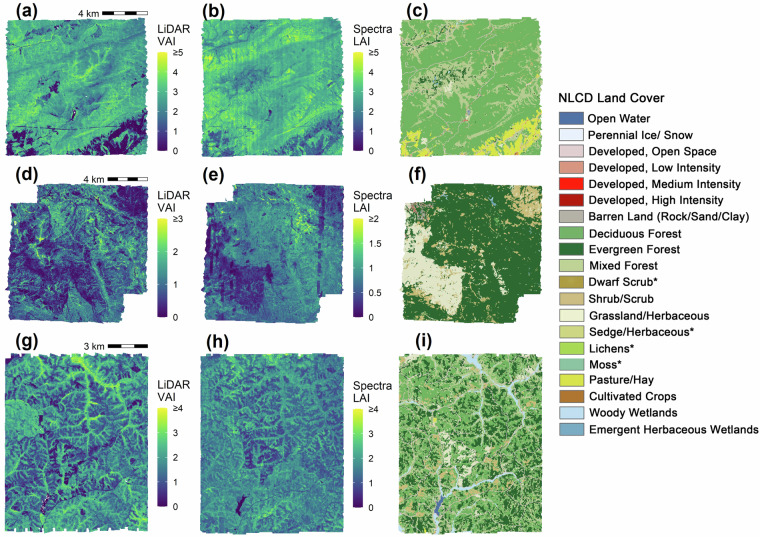
Structural diversity (SD) characterizes the volume and physical arrangement of biotic components in an ecosystem which control critical ecosystem functions and processes. LiDAR data provides detailed 3-D spatial position information of components and has been widely used to calculate SD. However, the intensive computation of SD metrics from extensive LiDAR datasets is time-consuming and challenging for researchers who lack access to high-performance computing resources. Moreover, a lack of understanding of LiDAR data and algorithms could lead to inconsistent SD metrics. Here, we developed a SD product using the Discrete-Return LiDAR Point Cloud from the NEON Aerial Observation Platform. This product provides SD metrics detailing height, density, openness, and complexity at a spatial resolution of 30 m, aligned to the Landsat grids, for 211 site-years for 45 Terrestrial NEON sites from 2013 to 2022. To accommodate various ecosystems with different understory heights, it includes three different cut-off heights (0.5 m, 2 m, and 5 m). This structural diversity product can enable various applications such as ecosystem productivity estimation and disturbance monitoring.

摘要

结构多样性(SD)表征生态系统中生物组分的体积和物理排列,这些生物组分控制着关键的生态系统功能和过程。激光雷达数据提供了组分的详细三维空间位置信息,并已被广泛用于计算结构多样性。然而,从大量激光雷达数据集中密集计算结构多样性指标对于缺乏高性能计算资源的研究人员来说既耗时又具有挑战性。此外,对激光雷达数据和算法缺乏了解可能导致结构多样性指标不一致。在此,我们利用来自NEON航空观测平台的离散回波激光雷达点云开发了一种结构多样性产品。该产品提供了结构多样性指标,详细说明了2013年至2022年期间45个陆地NEON站点211个站点年的高度、密度、开放性和复杂性,空间分辨率为30米,与陆地卫星网格对齐。为了适应不同林下高度的各种生态系统,它包括三种不同的截止高度(0.5米、2米和5米)。这种结构多样性产品可实现各种应用,如生态系统生产力估计和干扰监测。

https://cdn.ncbi.nlm.nih.gov/pmc/blobs/f04a/11522374/114b6412c8c8/41597_2024_4018_Fig7_HTML.jpg
https://cdn.ncbi.nlm.nih.gov/pmc/blobs/f04a/11522374/6d6a5bfa4407/41597_2024_4018_Fig1_HTML.jpg
https://cdn.ncbi.nlm.nih.gov/pmc/blobs/f04a/11522374/64ea058ca03f/41597_2024_4018_Fig2_HTML.jpg
https://cdn.ncbi.nlm.nih.gov/pmc/blobs/f04a/11522374/bda7deb79c89/41597_2024_4018_Fig3_HTML.jpg
https://cdn.ncbi.nlm.nih.gov/pmc/blobs/f04a/11522374/1d35cda66636/41597_2024_4018_Fig4_HTML.jpg
https://cdn.ncbi.nlm.nih.gov/pmc/blobs/f04a/11522374/cf9558d2db0c/41597_2024_4018_Fig5_HTML.jpg
https://cdn.ncbi.nlm.nih.gov/pmc/blobs/f04a/11522374/a0445970471a/41597_2024_4018_Fig6_HTML.jpg
https://cdn.ncbi.nlm.nih.gov/pmc/blobs/f04a/11522374/114b6412c8c8/41597_2024_4018_Fig7_HTML.jpg

相似文献

1
NEON-SD: A 30-m Structural Diversity Product Derived from the NEON Discrete-Return LiDAR Point Cloud.NEON-SD:一种源自NEON离散回波激光雷达点云的30米结构多样性产物。
Sci Data. 2024 Oct 29;11(1):1174. doi: 10.1038/s41597-024-04018-0.
2
Country-wide data of ecosystem structure from the third Dutch airborne laser scanning survey.来自第三次荷兰机载激光扫描调查的全国生态系统结构数据。
Data Brief. 2022 Dec 5;46:108798. doi: 10.1016/j.dib.2022.108798. eCollection 2023 Feb.
3
Lidar-derived structural-complexity data across four experimental forests.基于激光雷达的四个实验森林的结构复杂性数据。
Data Brief. 2024 Sep 18;57:110955. doi: 10.1016/j.dib.2024.110955. eCollection 2024 Dec.
4
Considerations for Achieving Cross-Platform Point Cloud Data Fusion across Different Dryland Ecosystem Structural States.实现跨不同旱地生态系统结构状态的跨平台点云数据融合的考量因素。
Front Plant Sci. 2018 Jan 10;8:2144. doi: 10.3389/fpls.2017.02144. eCollection 2017.
5
Measuring forest structure along productivity gradients in the Canadian boreal with small-footprint Lidar.利用小足迹激光雷达测量加拿大北方森林生产力梯度上的森林结构。
Environ Monit Assess. 2013 Aug;185(8):6617-34. doi: 10.1007/s10661-012-3051-9. Epub 2013 Jan 6.
6
Modelling vegetation understory cover using LiDAR metrics.利用激光雷达指标对植被下层植被进行建模。
PLoS One. 2019 Nov 27;14(11):e0220096. doi: 10.1371/journal.pone.0220096. eCollection 2019.
7
Mapping Understory Vegetation Density in Mediterranean Forests: Insights from Airborne and Terrestrial Laser Scanning Integration.利用机载和地面激光扫描集成技术对地中海森林林下植被密度进行制图。
Sensors (Basel). 2023 Jan 3;23(1):511. doi: 10.3390/s23010511.
8
Impact of data model and point density on aboveground forest biomass estimation from airborne LiDAR.数据模型和点密度对机载激光雷达估算森林地上生物量的影响。
Carbon Balance Manag. 2017 Dec;12(1):4. doi: 10.1186/s13021-017-0073-1. Epub 2017 Feb 15.
9
Leaf traits and canopy structure together explain canopy functional diversity: an airborne remote sensing approach.叶片性状和冠层结构共同解释了冠层功能多样性:一种航空遥感方法。
Ecol Appl. 2021 Mar;31(2):e02230. doi: 10.1002/eap.2230. Epub 2020 Nov 5.
10
Estimation of coniferous forest aboveground biomass with aggregated airborne small-footprint LiDAR full-waveforms.利用聚合机载小足迹激光雷达全波形估算针叶林地上生物量。
Opt Express. 2017 Aug 7;25(16):A851-A869. doi: 10.1364/OE.25.00A851.

本文引用的文献

1
High rates of primary production in structurally complex forests.结构复杂的森林中初级生产力的高比率。
Ecology. 2019 Oct;100(10):e02864. doi: 10.1002/ecy.2864. Epub 2019 Aug 30.
2
The role of canopy structural complexity in wood net primary production of a maturing northern deciduous forest.林冠结构复杂性对成熟北方落叶林木材净初级生产力的作用。
Ecology. 2011 Sep;92(9):1818-27. doi: 10.1890/10-2192.1.