Khosravi Yegane, Hosseinali Farhad, Adresi Mostafa
Department of Surveying Engineering, Faculty of Civil Engineering, Shahid Rajaee Teacher Training University, Tehran, Iran.
Department of Geotechnics and Water Engineering, Faculty of Civil Engineering, Shahid Rajaee Teacher Training University, Tehran, Iran.
Sci Rep. 2024 Dec 1;14(1):29836. doi: 10.1038/s41598-024-81121-7.
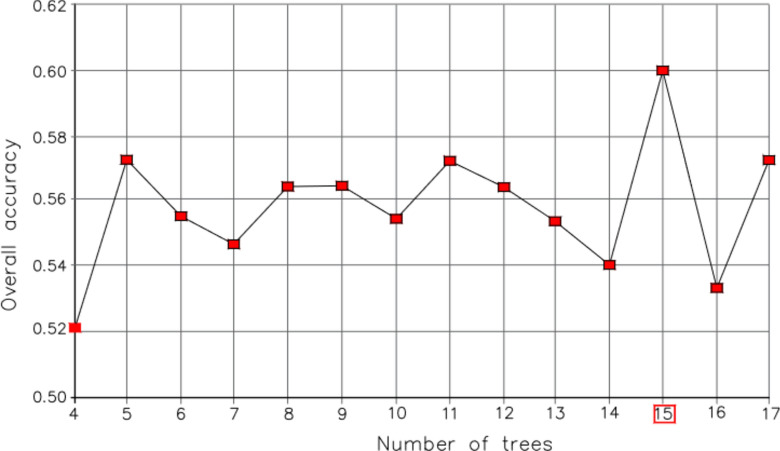
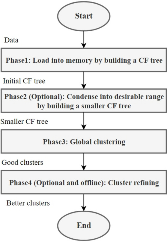
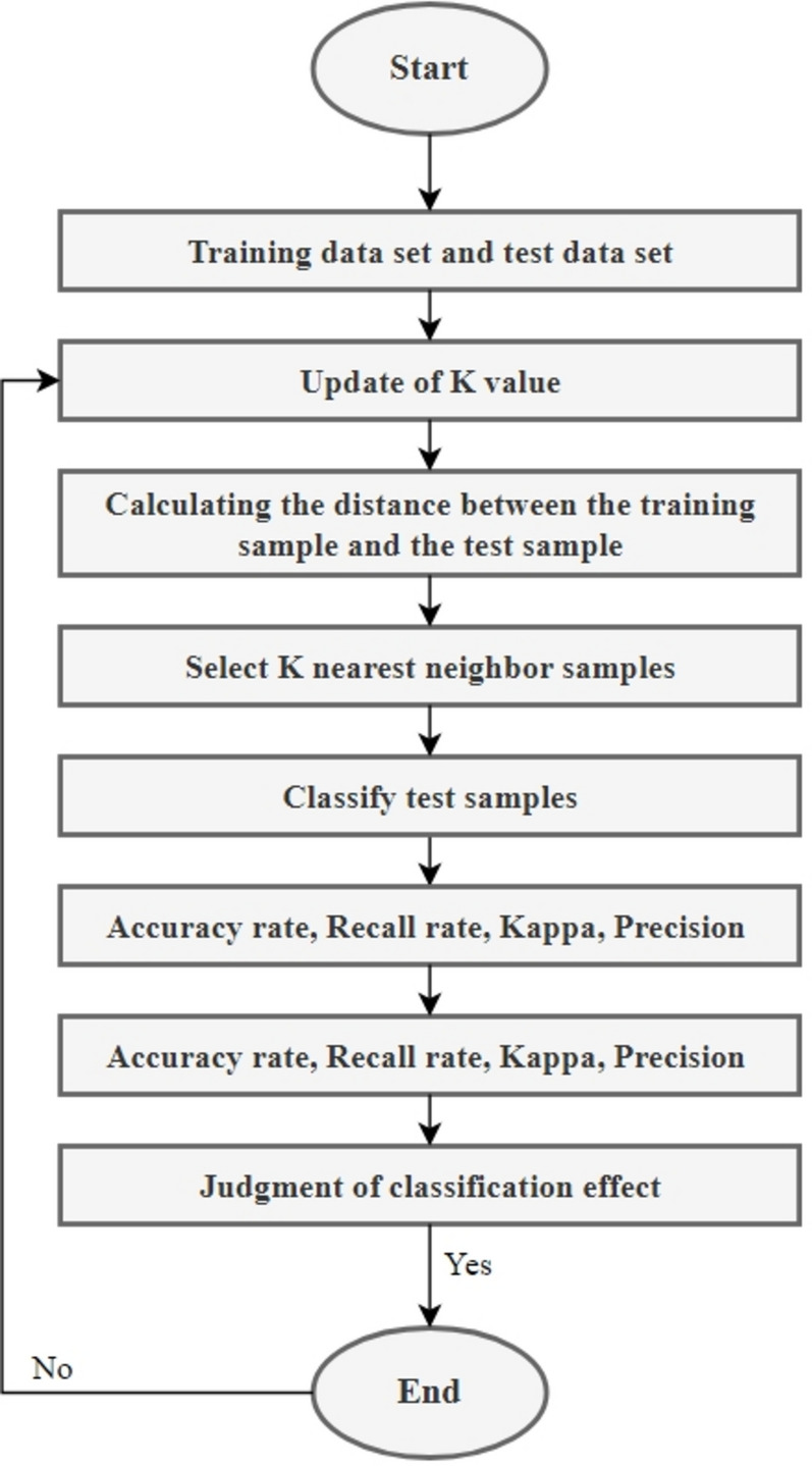
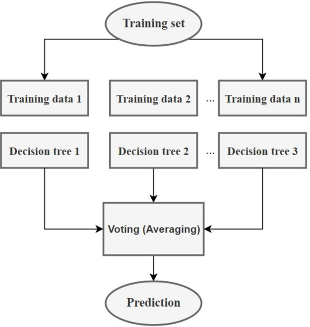
Identifying accident prone areas and the contributing environmental factors can save lives and enhance infrastructure durability. This research presents an innovative use of two hierarchical clustering methods (Agglomerative Hierarchical and BIRCH clustering algorithms) to detect accident hotspots with high accident rates on the Yazd-Kerman road, in Iran. These approaches identified clusters of accidents, highlighting significant clusters and categorizing their overlap as two accident prone areas. The high percentage of overlapping results from both methods indicates a high level of consistency in the findings. Through observations, field visits, police report analysis, and interviews with locals, the primary causes of accidents in accident prone areas were identified. In one of the accident prone areas, the most significant reasons for accidents included the presence of a resting area, insufficient lighting at curves, and poor road signage, which created a dilemma zone for drivers. In another accident prone area, the main contributing factor was reduced visibility during dust storms. Then, K-Nearest Neighbors and Random Forests machine learning algorithms were employed to predict the severity of accidents, using various input attributes such as lighting, climate, alignment slope, and road geometry. The K-Nearest Neighbor surpassed the Random Forest technique, achieving an overall accuracy of 71% in contrast to 60%. This study effectively evaluated the outcomes of clustering, uncovering the underlying causes of accidents to inform future practical interventions. Moreover, by predicting the severity of accidents along the road, a framework was developed to propose strategies for risk reduction.
识别事故多发区域及其相关环境因素可以挽救生命并提高基础设施的耐久性。本研究创新性地运用了两种层次聚类方法(凝聚层次聚类算法和BIRCH聚类算法),以检测伊朗亚兹德 - 克尔曼公路上事故率高的事故热点。这些方法识别出了事故集群,突出了重要集群,并将它们的重叠部分归类为两个事故多发区域。两种方法的高重叠率表明研究结果具有高度一致性。通过观察、实地考察、警方报告分析以及与当地人的访谈,确定了事故多发区域事故的主要原因。在其中一个事故多发区域,事故的最重要原因包括存在休息区、弯道照明不足以及道路标识不佳,这给驾驶员造成了困境区域。在另一个事故多发区域,主要促成因素是沙尘暴期间能见度降低。然后,使用照明、气候、路线坡度和道路几何形状等各种输入属性,采用K近邻和随机森林机器学习算法来预测事故的严重程度。K近邻算法超过了随机森林技术,总体准确率达到71%,而随机森林技术为60%。本研究有效地评估了聚类结果,揭示了事故的根本原因,为未来的实际干预提供参考。此外,通过预测道路沿线事故的严重程度,制定了一个框架来提出降低风险的策略。