Hakim Wahyu Luqmanul, Fadhillah Muhammad Fulki, Lee Seulki, Park Sungjae, Baek Won-Kyung, Hong Chang-Ki, Kim Hyun-Cheol, Lee Chang-Wook
Department of Science Education, Kangwon National University, 1 Gangwondaehak-gil, Chuncheon-si, 24341, Gangwon-do, Republic of Korea.
Korea Ocean Satellite Center, Korea Institute of Ocean Science and Technology, Haeyang-ro, Yeongdo- gu, Busan, 49111, Republic of Korea.
Sci Rep. 2024 Dec 28;14(1):30709. doi: 10.1038/s41598-024-79128-1.
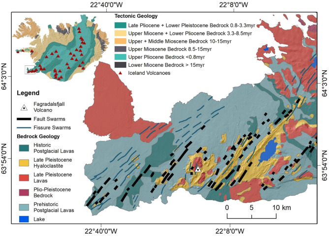
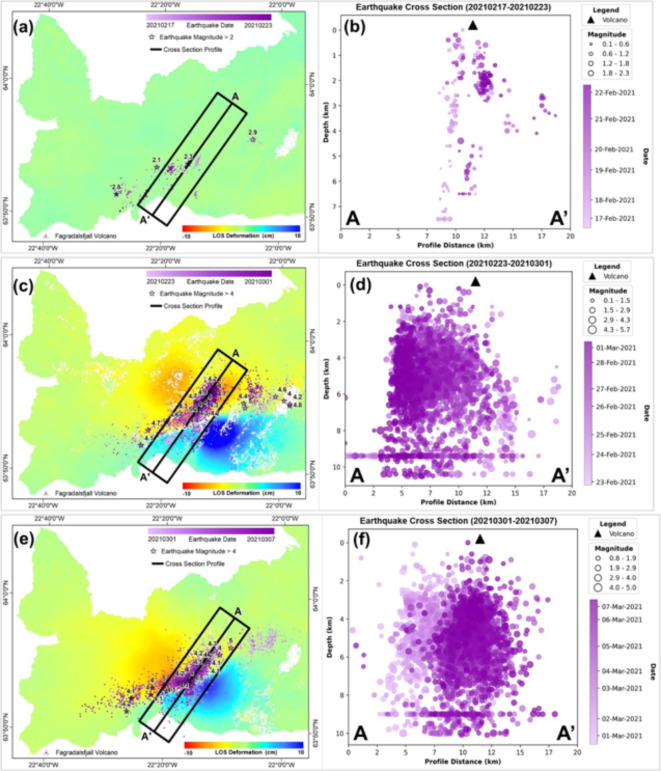
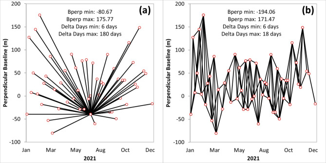
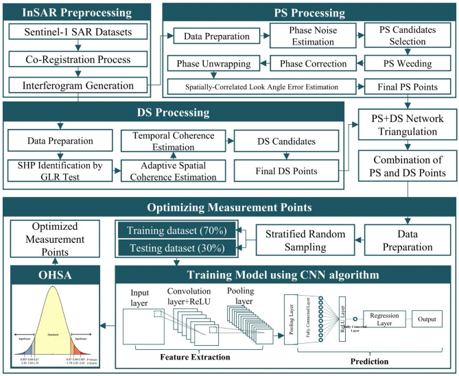
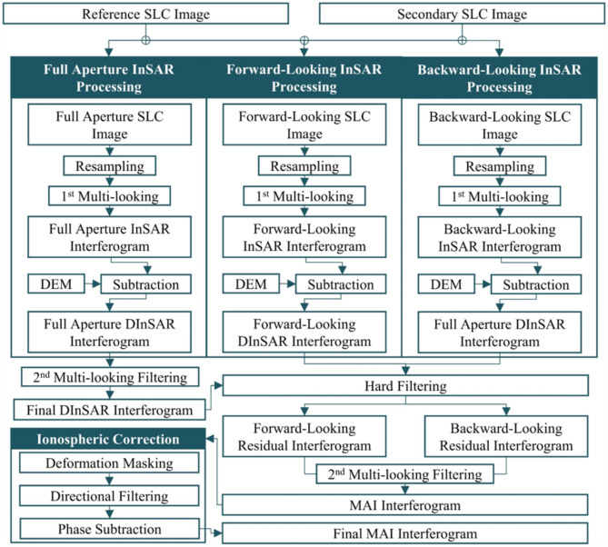
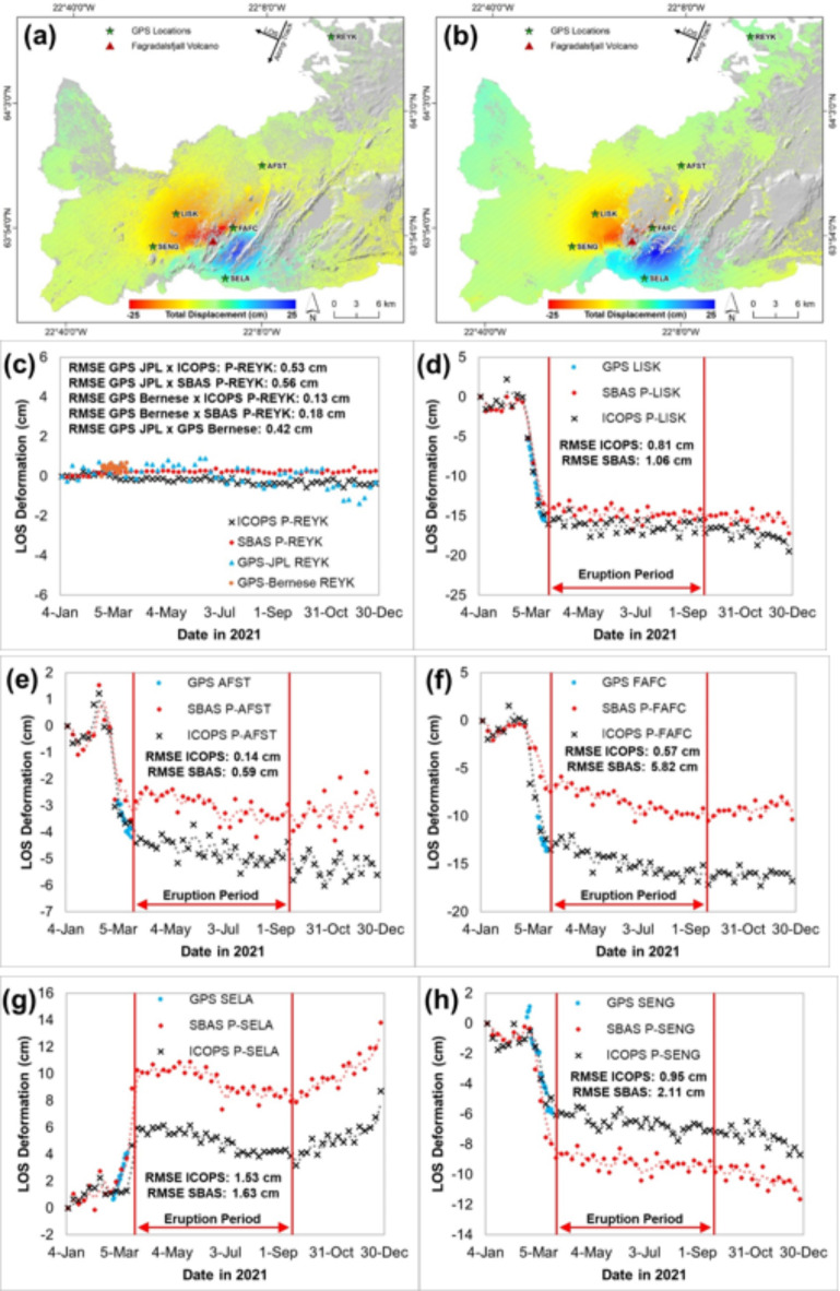
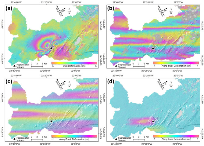
The eruption in Fagradalsfjall Volcano, located in Reykjanes Peninsula, Iceland, from several centuries' dormant states, occurred for the first time on March 19, 2021. Observations of Fagradalsfjall Volcano were conducted in 2021, and the eruption period lasted for six months until 18 September 2021. Six days pair of interferograms were generated from ninety synthetic aperture radar (SAR) data. Thus, the SAR data will be acquired from the Sentinel-1 satellite from January until December 2021. Time-series measurements were conducted using a combination of persistent scatterer (PS) and distributed scatterer (DS) points to produce denser measurement points (MPs) in the study area. The improved combined scatterers interferometry with optimized point scatterers (ICOPS) algorithm is the time-series method that utilizes both PS and DS MPs and optimizes those combined MPs using a deep learning algorithm over different temporal intervals and using a statistical clustering approach to optimize the MPs spatially. Validation was conducted by comparing the ICOPS result with GPS measurement in Reykjavik. The comparison with the GPS measurement was performed to validate the line-of-sight (LOS) deformation from the ICOPS measurement, which resulted in an RMSE value of about 0.58 cm, which is considered a good correlation. Besides the time-series Interferometry SAR (InSAR) measurement, we used the integrated InSAR and multiple aperture interferometry (MAI) methods to estimate both LOS and along-track surface deformation, respectively, during the Fagradalsfjall, Iceland volcanic eruption. A pair of ALOS-2 data was used between 28 February 2021 and 23 May 2021. The result from the MAI method shows a deformation of approximately ± 2 mm in the azimuth direction around Fagradalsfjall Volcano. The deformation around Fagradalsfjall Volcano was suggested to be due to the activity of the magma reservoir beneath the Earth's surface, which was formed by dike intrusion. The analysis of the seismicity in Fagradalsfjall was discussed by visualization of the distribution of earthquakes during the deformation occurrence. Further analysis can be conducted by applying multitrack analysis to find the 3D deformation pattern due to the eruption.
位于冰岛雷克雅内斯半岛的法格拉达尔火山从几个世纪的休眠状态中首次喷发,于2021年3月19日发生。2021年对法格拉达尔火山进行了观测,喷发期持续了六个月,直至2021年9月18日。从90个合成孔径雷达(SAR)数据生成了六天的干涉图对。因此,SAR数据将在2021年1月至12月期间从哨兵-1卫星获取。使用永久散射体(PS)和分布式散射体(DS)点的组合进行时间序列测量,以在研究区域产生更密集的测量点(MPs)。改进的具有优化点散射体的组合散射体干涉测量法(ICOPS)算法是一种时间序列方法,它利用PS和DS MPs,并通过深度学习算法在不同时间间隔对这些组合MPs进行优化,并使用统计聚类方法在空间上优化MPs。通过将ICOPS结果与雷克雅未克的GPS测量结果进行比较来进行验证。与GPS测量结果的比较是为了验证ICOPS测量的视线(LOS)变形,其均方根误差(RMSE)值约为0.58厘米,这被认为是良好的相关性。除了时间序列干涉合成孔径雷达(InSAR)测量外,我们还使用综合InSAR和多孔径干涉测量(MAI)方法分别估计了冰岛法格拉达尔火山喷发期间的LOS和沿轨道表面变形。在2021年2月28日至2021年5月23日期间使用了一对ALOS-2数据。MAI方法的结果显示,法格拉达尔火山周围方位方向的变形约为±2毫米。法格拉达尔火山周围的变形被认为是由于地表以下岩浆库的活动造成的,该岩浆库是由岩脉侵入形成的。通过可视化变形发生期间地震的分布来讨论法格拉达尔火山的地震活动性分析。可以通过应用多轨道分析来进行进一步分析,以找到喷发引起的三维变形模式。